Property Record
1589 Route 206, Tabernacle, NJ 08088
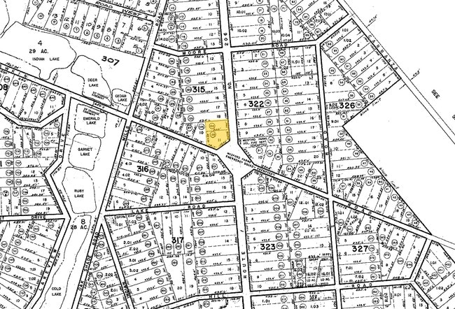
Property Detail
1589 Route 206
Philadelphia-Camden-Wilmington, PA-NJ-DE-MD
BURLINGTON
35-00315-0000-00011
New Jersey
Vacantlandnec
11
B and X Area of moderate flood hazard, usually the area between the limits of the 100-year and 500-year floods.
1 AC
2024
South Burlington County
2025
Philadelphia
703600
NEARBY LISTINGS FOR SALE OR LEASE
DEMOGRAPHICS near 1589 Route 206
1 mile
3 mile
5 mile
2025 Total Population
1,991
11,833
32,748
2030 Population
2,062
12,122
33,536
Pop Growth 2025-2030
+ 3.57%
+ 2.44%
+ 2.41%
Average Age
44
47
45
2025 Total Households
743
4,630
12,340
HH Growth 2025-2030
+ 3.77%
+ 2.59%
+ 2.54%
Median Household Inc
$103,313
$106,193
$119,169
Avg Household Size
2.70
2.50
2.60
2025 Avg HH Vehicles
3.00
2.00
2.00
Median Home Value
$425,431
$389,027
$422,358
Median Year Built
1971
1977
1976
Nearby Places
Map Layers
Map Styles
 Street
 Aerial
Transit
 Traffic
 Biking
Places
Listings with unknown addresses are not visible on the map
- Restaurants
- Banks
- Shops
- Fitness
- Groceries
PUBLIC TRANSPORTATION
AIRPORT
Philadelphia International
Drive
Walk
Distance
Philadelphia International
50 min
36.7 mi
Atlantic City International
Drive
Walk
Distance
Atlantic City International
61 min
39.9 mi
Freight Ports
Port of Philadelphia
Drive
Walk
Distance
Port of Philadelphia
1 min
20.6 mi
SALE & LEASE HISTORY
LISTING DATE
SALE/LEASE

Aug 02, 2017
For Sale
Nearby Properties
Address
Land Use
TOTAL SIZE
Lot Size
Zoning
Address
Land Use
TOTAL SIZE
Lot Size
Zoning
103.84 AC
PPE
Address
Land Use
TOTAL SIZE
Lot Size
Zoning
46.97 AC
Address
Land Use
TOTAL SIZE
Lot Size
Zoning
Address
Land Use
TOTAL SIZE
Lot Size
Zoning
9.15 AC
Address
Land Use
TOTAL SIZE
Lot Size
Zoning
20.84 AC
Address
Land Use
TOTAL SIZE
Lot Size
Zoning
1,284 SF
20.03 AC
Address
Land Use
TOTAL SIZE
Lot Size
Zoning
370.06 AC
Address
Land Use
TOTAL SIZE
Lot Size
Zoning
8.95 AC
RG
Address
Land Use
TOTAL SIZE
Lot Size
Zoning
40.08 AC
Address
Land Use
TOTAL SIZE
Lot Size
Zoning
1,750 SF
7.91 AC
I
Address
Land Use
TOTAL SIZE
Lot Size
Zoning
5.63 AC
HC
Address
Land Use
TOTAL SIZE
Lot Size
Zoning
15.20 AC
Address
Land Use
TOTAL SIZE
Lot Size
Zoning
864 SF
4.54 AC
Address
Land Use
TOTAL SIZE
Lot Size
Zoning
2.41 AC
Address
Land Use
TOTAL SIZE
Lot Size
Zoning
Address
Land Use
TOTAL SIZE
Lot Size
Zoning
4.30 AC
RGD2
Address
Land Use
TOTAL SIZE
Lot Size
Zoning
9.37 AC
I
Address
Land Use
TOTAL SIZE
Lot Size
Zoning
3.45 AC
I
Address
Land Use
TOTAL SIZE
Lot Size
Zoning
9,736 SF
4.43 AC
RGD
Address
Land Use
TOTAL SIZE
Lot Size
Zoning
24,360 SF
15.77 AC
I
Address
Land Use
TOTAL SIZE
Lot Size
Zoning
2.09 AC
HC
Address
Land Use
TOTAL SIZE
Lot Size
Zoning
2.36 AC
Address
Land Use
TOTAL SIZE
Lot Size
Zoning
5.30 AC
I
Address
Land Use
TOTAL SIZE
Lot Size
Zoning
3.31 AC
Address
Land Use
TOTAL SIZE
Lot Size
Zoning
13.60 AC
I
Address
Land Use
TOTAL SIZE
Lot Size
Zoning
2.86 AC
Address
Land Use
TOTAL SIZE
Lot Size
Zoning
3.28 AC
HC
Address
Land Use
TOTAL SIZE
Lot Size
Zoning
1,351 SF
1.38 AC
HC
Address
Land Use
TOTAL SIZE
Lot Size
Zoning
8,750 SF
3.13 AC
I
Address
Land Use
TOTAL SIZE
Lot Size
Zoning
4.62 AC
I
The World's #1 Commercial Real Estate Marketplace
Connect with us
© 2026 CoStar Group
The information above has been obtained from sources believed reliable. While we do not doubt its accuracy we have not verified it and make no guarantee, warranty or representation about it. It is your responsibility to independently confirm its accuracy and completeness. Any projections, opinions, assumptions, or estimates used are for example only and do not represent the current or future performance of the property. The value of this transaction to you depends on tax and other factors which should be evaluated by your tax, financial, and legal advisors. You and your advisors should conduct a careful, independent investigation of the property to determine to your satisfaction the suitability of the property for your needs.