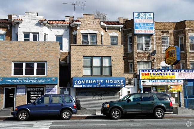
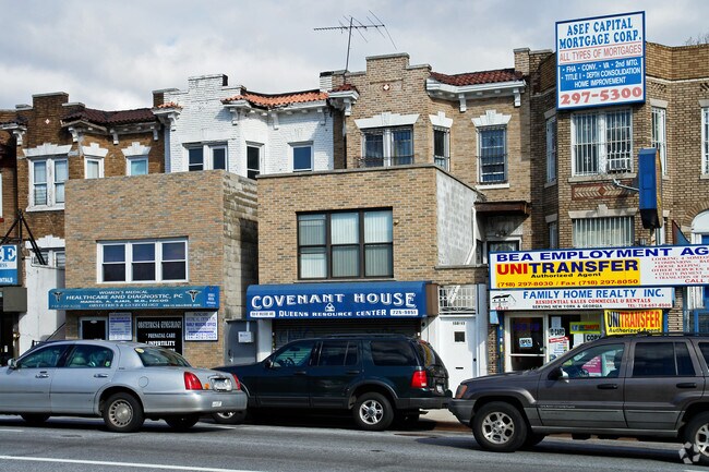
Property Record
15917 Hillside Ave, Jamaica, NY 11432
NEARBY LISTINGS FOR SALE OR LEASE
Property Detail
15917 Hillside Ave
09769-0089
Mpao Of 35 Lots 4Th Ward
Commercialofficeresidentialmixeduse
Queens
X
New York
3604970233F
89
2024
0.04 AC
2025
South Queens
044602
Long Island (New York)
1,648 SF
New York-Jersey City-White Plains, NY-NJ
DEMOGRAPHICS near 15917 Hillside Ave
1 Mile
3 Mile
5 Mile
2024 Total Population
118,048
653,375
1,583,774
2029 Population
112,159
608,664
1,472,249
Pop Growth 2024-2029
(4.99%)
(6.84%)
(7.04%)
Average Age
40
41
42
2024 Total Households
37,819
218,566
525,695
HH Growth 2024-2029
(4.98%)
(6.88%)
(7.21%)
Median Household Inc
$63,600
$75,933
$72,610
Avg Household Size
2.90
2.80
2.90
2024 Avg HH Vehicles
1.00
1.00
1.00
Median Home Value
$588,450
$661,729
$669,253
Median Year Built
1958
1951
1952
Nearby Places
Map Layers
Map Styles
 Street
 Aerial
- Restaurants
- Banks
- Shops
- Fitness
- Groceries
PUBLIC TRANSPORTATION
TRANSIT/SUBWAY
Parsons Boulevard (F - New York MTA Subway (The Subway))
DRIVE
WALK
Distance
Parsons Boulevard (F - New York MTA Subway (The Subway))
0 min
1 min
0.0 mi
Sutphin Boulevard (F - New York MTA Subway (The Subway))
DRIVE
WALK
Distance
Sutphin Boulevard (F - New York MTA Subway (The Subway))
1 min
8 min
0.4 mi
Jamaica Center-Parsons/Archer (E - New York MTA Subway (The Subway), J - New York MTA Subway (The Subway), Z - New York MTA Subway (The Subway))
DRIVE
WALK
Distance
Jamaica Center-Parsons/Archer (E - New York MTA Subway (The Subway), J - New York MTA Subway (The Subway), Z - New York MTA Subway (The Subway))
2 min
10 min
0.5 mi
169 Street (F - New York MTA Subway (The Subway))
DRIVE
WALK
Distance
169 Street (F - New York MTA Subway (The Subway))
1 min
10 min
0.5 mi
Sutphin Boulevard-Archer Avenue-JFK Airport (E - New York MTA Subway (The Subway), J - New York MTA Subway (The Subway), Z - New York MTA Subway (The Subway))
DRIVE
WALK
Distance
Sutphin Boulevard-Archer Avenue-JFK Airport (E - New York MTA Subway (The Subway), J - New York MTA Subway (The Subway), Z - New York MTA Subway (The Subway))
2 min
15 min
0.8 mi
COMMUTER RAIL
Jamaica Station (Babylon Branch - Long Island Rail Road, Far Rockaway Branch - Long Island Rail Road, Hempstead Branch - Long Island Rail Road, Long Beach Branch - Long Island Rail Road, Montauk Branch - Long Island Rail Road, Oyster Bay Branch - Long Island Rail Road, Port Jefferson Branch - Long Island Rail Road, Ronkonkoma Branch - Long Island Rail Road, West Hempstead Branch - Long Island Rail Road)
DRIVE
WALK
Distance
Jamaica Station (Babylon Branch - Long Island Rail Road, Far Rockaway Branch - Long Island Rail Road, Hempstead Branch - Long Island Rail Road, Long Beach Branch - Long Island Rail Road, Montauk Branch - Long Island Rail Road, Oyster Bay Branch - Long Island Rail Road, Port Jefferson Branch - Long Island Rail Road, Ronkonkoma Branch - Long Island Rail Road, West Hempstead Branch - Long Island Rail Road)
3 min
16 min
0.8 mi
DRIVE
WALK
Distance
3 min
1.6 mi
AIRPORT
John F Kennedy International
DRIVE
WALK
Distance
John F Kennedy International
10 min
6.6 mi
LaGuardia
DRIVE
WALK
Distance
LaGuardia
13 min
7.1 mi
Newark Liberty International
DRIVE
WALK
Distance
Newark Liberty International
39 min
26.8 mi
Freight Ports
NY - Red Hook Container Terminal
DRIVE
WALK
Distance
NY - Red Hook Container Terminal
25 min
15.6 mi
SALE & LEASE HISTORY
LISTING DATE
SALE/LEASE

Sep 25, 2016
For Lease
Nearby Properties
Address
Land Use
TOTAL SIZE
Lot Size
Zoning
Address
Land Use
TOTAL SIZE
Lot Size
Zoning
4,528,000 SF
94.27 AC
R4
Address
Land Use
TOTAL SIZE
Lot Size
Zoning
2,078,606 SF
58.93 AC
R4
Address
Land Use
TOTAL SIZE
Lot Size
Zoning
1,845,252 SF
172 AC
C8-1
Address
Land Use
TOTAL SIZE
Lot Size
Zoning
1,069,367 SF
14.65 AC
R4
Address
Land Use
TOTAL SIZE
Lot Size
Zoning
54,170 SF
229.57 AC
PARK
Address
Land Use
TOTAL SIZE
Lot Size
Zoning
1,516,458 SF
5.97 AC
R7-1
Address
Land Use
TOTAL SIZE
Lot Size
Zoning
532,011 SF
2.48 AC
R6
Address
Land Use
TOTAL SIZE
Lot Size
Zoning
15,000 SF
255.27 AC
PARK
Address
Land Use
TOTAL SIZE
Lot Size
Zoning
13,500 SF
104 AC
PARK
Address
Land Use
TOTAL SIZE
Lot Size
Zoning
731,247 SF
56.09 AC
R3-2
Address
Land Use
TOTAL SIZE
Lot Size
Zoning
947 SF
101.82 AC
PARK
Address
Land Use
TOTAL SIZE
Lot Size
Zoning
126.85 AC
PARK
Address
Land Use
TOTAL SIZE
Lot Size
Zoning
4,800 SF
80.10 AC
PARK
Address
Land Use
TOTAL SIZE
Lot Size
Zoning
1,186,778 SF
31.45 AC
R4
Address
Land Use
TOTAL SIZE
Lot Size
Zoning
738,000 SF
1.92 AC
C6-3
Address
Land Use
TOTAL SIZE
Lot Size
Zoning
577,654 SF
5.38 AC
R6
Address
Land Use
TOTAL SIZE
Lot Size
Zoning
291,589 SF
1.55 AC
C6-3
Address
Land Use
TOTAL SIZE
Lot Size
Zoning
82.92 AC
PARK
Address
Land Use
TOTAL SIZE
Lot Size
Zoning
2,193 SF
94.72 AC
PARK
Address
Land Use
TOTAL SIZE
Lot Size
Zoning
521,944 SF
16.68 AC
R4
Address
Land Use
TOTAL SIZE
Lot Size
Zoning
307,038 SF
7.84 AC
M1-1
Address
Land Use
TOTAL SIZE
Lot Size
Zoning
234,452 SF
2.99 AC
R4
Address
Land Use
TOTAL SIZE
Lot Size
Zoning
320,535 SF
1.52 AC
C4-4A
Address
Land Use
TOTAL SIZE
Lot Size
Zoning
377,896 SF
11.36 AC
R3-2
Address
Land Use
TOTAL SIZE
Lot Size
Zoning
384,249 SF
5.56 AC
R5
Address
Land Use
TOTAL SIZE
Lot Size
Zoning
364,424 SF
C5-3
Address
Land Use
TOTAL SIZE
Lot Size
Zoning
478,384 SF
1.23 AC
C6-3
Address
Land Use
TOTAL SIZE
Lot Size
Zoning
360,000 SF
8.78 AC
R6
Address
Land Use
TOTAL SIZE
Lot Size
Zoning
569,583 SF
2.28 AC
C4-5X
Address
Land Use
TOTAL SIZE
Lot Size
Zoning
230,580 SF
3.41 AC
C8-1
The World's #1 Commercial Real Estate Marketplace
Connect with us
© 2025 CoStar Group
The information above has been obtained from sources believed reliable. While we do not doubt its accuracy we have not verified it and make no guarantee, warranty or representation about it. It is your responsibility to independently confirm its accuracy and completeness. Any projections, opinions, assumptions, or estimates used are for example only and do not represent the current or future performance of the property. The value of this transaction to you depends on tax and other factors which should be evaluated by your tax, financial, and legal advisors. You and your advisors should conduct a careful, independent investigation of the property to determine to your satisfaction the suitability of the property for your needs.