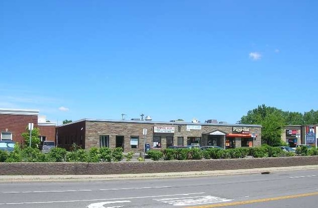
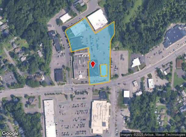
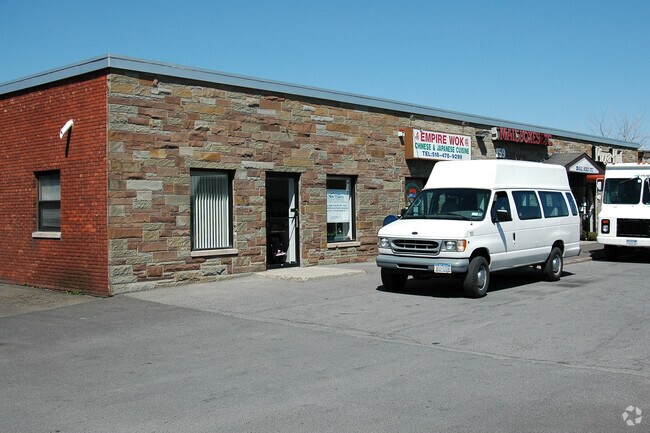
Property Record
159 Delaware Ave, Delmar, NY 12054
NEARBY LISTINGS FOR SALE OR LEASE
Property Detail
159 Delaware Ave
012200-086-006-0001-024-001-0000
Albany
Professionalbldglegalinsurancerealestateetc
New York
X
24.001
36001C0193D
3.80 AC
2025
W Outer Albany County
2024
Albany/Schenectady/Troy
014100
Albany-Schenectady-Troy, NY
13,800 SF
DEMOGRAPHICS near 159 Delaware Ave
1 Mile
3 Mile
5 Mile
2024 Total Population
4,519
80,706
161,247
2029 Population
4,478
79,767
159,528
Pop Growth 2024-2029
(0.91%)
(1.16%)
(1.07%)
Average Age
43
39
39
2024 Total Households
1,794
35,040
67,729
HH Growth 2024-2029
(0.95%)
(1.26%)
(1.08%)
Median Household Inc
$101,702
$74,184
$67,690
Avg Household Size
2.40
2.10
2.10
2024 Avg HH Vehicles
2.00
1.00
1.00
Median Home Value
$276,072
$255,719
$245,044
Median Year Built
1959
1953
1957
Nearby Places
Map Layers
Map Styles
 Street
 Aerial
- Restaurants
- Banks
- Shops
- Fitness
- Groceries
PUBLIC TRANSPORTATION
COMMUTER RAIL
DRIVE
WALK
Distance
12 min
4.7 mi
AIRPORT
Albany International
DRIVE
WALK
Distance
Albany International
27 min
12.7 mi
Freight Ports
Albany, NY Port
DRIVE
WALK
Distance
Albany, NY Port
10 min
4.2 mi
SALE & LEASE HISTORY
LISTING DATE
SALE/LEASE

Jan 08, 2020
For Lease
Dec 12, 2017
For Lease
Nearby Properties
Address
Land Use
TOTAL SIZE
Lot Size
Zoning
Address
Land Use
TOTAL SIZE
Lot Size
Zoning
901,573 SF
38 AC
CO
Address
Land Use
TOTAL SIZE
Lot Size
Zoning
11,372 SF
30 AC
CO
Address
Land Use
TOTAL SIZE
Lot Size
Zoning
674,048 SF
7.40 AC
CO
Address
Land Use
TOTAL SIZE
Lot Size
Zoning
599,952 SF
28.30 AC
CO
Address
Land Use
TOTAL SIZE
Lot Size
Zoning
442,188 SF
15.10 AC
CO
Address
Land Use
TOTAL SIZE
Lot Size
Zoning
502,950 SF
12.50 AC
CO
Address
Land Use
TOTAL SIZE
Lot Size
Zoning
133,984 SF
205.20 AC
C2
Address
Land Use
TOTAL SIZE
Lot Size
Zoning
152,951 SF
3.70 AC
CO
Address
Land Use
TOTAL SIZE
Lot Size
Zoning
197,169 SF
5 AC
CO
Address
Land Use
TOTAL SIZE
Lot Size
Zoning
206.10 AC
C2
Address
Land Use
TOTAL SIZE
Lot Size
Zoning
802,560 SF
5.70 AC
R4
Address
Land Use
TOTAL SIZE
Lot Size
Zoning
9,208 SF
290.80 AC
LC
Address
Land Use
TOTAL SIZE
Lot Size
Zoning
191.95 AC
LC
Address
Land Use
TOTAL SIZE
Lot Size
Zoning
156,056 SF
1.31 AC
CO
Address
Land Use
TOTAL SIZE
Lot Size
Zoning
12,660 SF
15.60 AC
CO
Address
Land Use
TOTAL SIZE
Lot Size
Zoning
5,248 SF
200.90 AC
LC
Address
Land Use
TOTAL SIZE
Lot Size
Zoning
105.28 AC
C2
Address
Land Use
TOTAL SIZE
Lot Size
Zoning
99,300 SF
4.66 AC
R2B
Address
Land Use
TOTAL SIZE
Lot Size
Zoning
211,848 SF
27.20 AC
R2A
Address
Land Use
TOTAL SIZE
Lot Size
Zoning
78,458 SF
28.70 AC
R1B
Address
Land Use
TOTAL SIZE
Lot Size
Zoning
441,152 SF
3.32 AC
CO
Address
Land Use
TOTAL SIZE
Lot Size
Zoning
198,884 SF
5.35 AC
CO
Address
Land Use
TOTAL SIZE
Lot Size
Zoning
26,010 SF
14.65 AC
CO
Address
Land Use
TOTAL SIZE
Lot Size
Zoning
96,000 SF
3.92 AC
CO
Address
Land Use
TOTAL SIZE
Lot Size
Zoning
404,796 SF
2.23 AC
CO
Address
Land Use
TOTAL SIZE
Lot Size
Zoning
65,219 SF
35 AC
R1B
Address
Land Use
TOTAL SIZE
Lot Size
Zoning
103,982 SF
4.70 AC
CO
Address
Land Use
TOTAL SIZE
Lot Size
Zoning
121,340 SF
7.10 AC
CO
Address
Land Use
TOTAL SIZE
Lot Size
Zoning
59,442 SF
69.20 AC
R1LL
Address
Land Use
TOTAL SIZE
Lot Size
Zoning
315,680 SF
73.80 AC
RA
The World's #1 Commercial Real Estate Marketplace
Connect with us
© 2025 CoStar Group
The information above has been obtained from sources believed reliable. While we do not doubt its accuracy we have not verified it and make no guarantee, warranty or representation about it. It is your responsibility to independently confirm its accuracy and completeness. Any projections, opinions, assumptions, or estimates used are for example only and do not represent the current or future performance of the property. The value of this transaction to you depends on tax and other factors which should be evaluated by your tax, financial, and legal advisors. You and your advisors should conduct a careful, independent investigation of the property to determine to your satisfaction the suitability of the property for your needs.