Property Record
179 Old Bridge St, Jacksonville, NC 28540


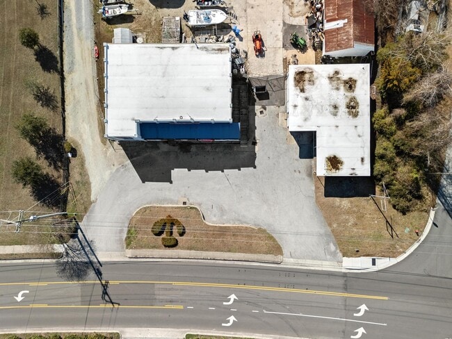

This Property Is For Sale
NEARBY LISTINGS FOR SALE OR LEASE
-
-
View all Jacksonville listings for sale on LoopNet.com
Property Detail
179 Old Bridge St
Other Market Areas
William H Jr & Deborah Tarplee
Jacksonville, NC
Onslow
160763
North Carolina
Sfr
1.23 AC
AE
North Carolina Southeast Area
3720436600J
DEMOGRAPHICS near 179 Old Bridge St
1 Mile
3 Mile
5 Mile
2024 Total Population
2,379
29,431
72,393
2029 Population
2,556
30,850
76,027
Pop Growth 2024-2029
+ 7.44%
+ 4.82%
+ 5.02%
Average Age
37
33
32
2024 Total Households
992
9,769
26,221
HH Growth 2024-2029
+ 7.96%
+ 5.44%
+ 5.43%
Median Household Inc
$50,170
$47,668
$48,217
Avg Household Size
2.20
2.40
2.50
2024 Avg HH Vehicles
2.00
2.00
2.00
Median Home Value
$117,320
$161,506
$159,463
Median Year Built
1963
1974
1989
Nearby Places
Map Layers
Map Styles
 Street
 Aerial
- Restaurants
- Banks
- Shops
- Fitness
- Groceries
PUBLIC TRANSPORTATION
AIRPORT
Albert J Ellis
DRIVE
WALK
Distance
Albert J Ellis
26 min
13.5 mi
Freight Ports
Port of Morehead City
DRIVE
WALK
Distance
Port of Morehead City
70 min
44.6 mi
Nearby Properties
Address
Land Use
TOTAL SIZE
Lot Size
Zoning
Address
Land Use
TOTAL SIZE
Lot Size
Zoning
189,717 SF
1.93 AC
DTB
Address
Land Use
TOTAL SIZE
Lot Size
Zoning
27,193 SF
20.13 AC
RMF-HD
Address
Land Use
TOTAL SIZE
Lot Size
Zoning
10,560 SF
42.87 AC
RSF-7
Address
Land Use
TOTAL SIZE
Lot Size
Zoning
38,147 SF
3.14 AC
DTB
Address
Land Use
TOTAL SIZE
Lot Size
Zoning
94,547 SF
6.37 AC
DTB
Address
Land Use
TOTAL SIZE
Lot Size
Zoning
211,186 SF
22.08 AC
CC
Address
Land Use
TOTAL SIZE
Lot Size
Zoning
93,849 SF
60 AC
HB
Address
Land Use
TOTAL SIZE
Lot Size
Zoning
16,248 SF
21.09 AC
RMF-HD
Address
Land Use
TOTAL SIZE
Lot Size
Zoning
94,263 SF
5.88 AC
DTB
Address
Land Use
TOTAL SIZE
Lot Size
Zoning
464 SF
458.49 AC
H-IN
Address
Land Use
TOTAL SIZE
Lot Size
Zoning
79,581 SF
35 AC
O+I
Address
Land Use
TOTAL SIZE
Lot Size
Zoning
2,480 SF
11.59 AC
RMF-HD
Address
Land Use
TOTAL SIZE
Lot Size
Zoning
27,856 SF
20.11 AC
CC
Address
Land Use
TOTAL SIZE
Lot Size
Zoning
11,064 SF
17.85 AC
RMF-HD
Address
Land Use
TOTAL SIZE
Lot Size
Zoning
10,368 SF
23.17 AC
CC
Address
Land Use
TOTAL SIZE
Lot Size
Zoning
140,403 SF
15.78 AC
CC
Address
Land Use
TOTAL SIZE
Lot Size
Zoning
15,746 SF
27.64 AC
RSF-7
Address
Land Use
TOTAL SIZE
Lot Size
Zoning
58,570 SF
8.95 AC
DTB
Address
Land Use
TOTAL SIZE
Lot Size
Zoning
36,567 SF
25.60 AC
HB
Address
Land Use
TOTAL SIZE
Lot Size
Zoning
7,550 SF
18.40 AC
RSF-7
Address
Land Use
TOTAL SIZE
Lot Size
Zoning
18,480 SF
93 AC
IND
Address
Land Use
TOTAL SIZE
Lot Size
Zoning
39,552 SF
20.17 AC
RSF-7
Address
Land Use
TOTAL SIZE
Lot Size
Zoning
17,939 SF
5.80 AC
DTB
Address
Land Use
TOTAL SIZE
Lot Size
Zoning
62,733 SF
12.80 AC
RMF-HD
Address
Land Use
TOTAL SIZE
Lot Size
Zoning
22,128 SF
12.38 AC
OI
Address
Land Use
TOTAL SIZE
Lot Size
Zoning
67,945 SF
2.35 AC
DTB
Address
Land Use
TOTAL SIZE
Lot Size
Zoning
29,117 SF
25.52 AC
CC
Address
Land Use
TOTAL SIZE
Lot Size
Zoning
29,476 SF
4.95 AC
CC
Address
Land Use
TOTAL SIZE
Lot Size
Zoning
20,000 SF
18.97 AC
IND
Address
Land Use
TOTAL SIZE
Lot Size
Zoning
46,116 SF
1.20 AC
DTB
The World's #1 Commercial Real Estate Marketplace
Connect with us
© 2026 CoStar Group
The information above has been obtained from sources believed reliable. While we do not doubt its accuracy we have not verified it and make no guarantee, warranty or representation about it. It is your responsibility to independently confirm its accuracy and completeness. Any projections, opinions, assumptions, or estimates used are for example only and do not represent the current or future performance of the property. The value of this transaction to you depends on tax and other factors which should be evaluated by your tax, financial, and legal advisors. You and your advisors should conduct a careful, independent investigation of the property to determine to your satisfaction the suitability of the property for your needs.