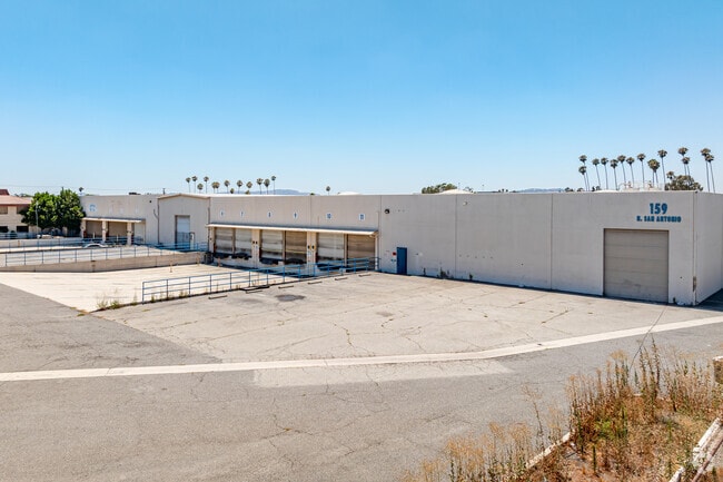
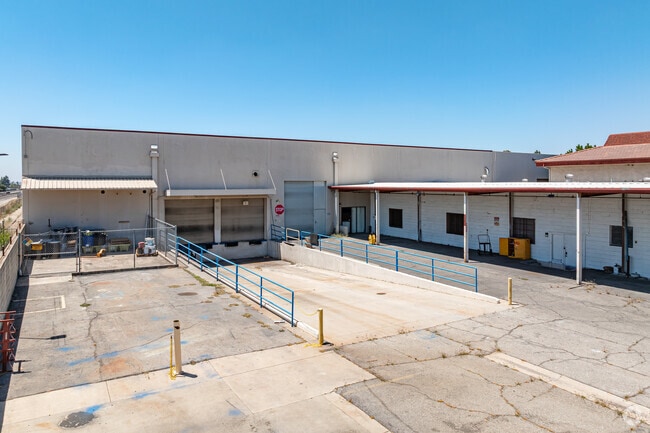
Property Record
159 N San Antonio Ave, Pomona, CA 91767

Save to a Folder
{{folder.Name}}
{{folder.ListingIds.length}} Properties
{{folder.ListingIds.length}} Property
Create a New Folder
Current Lease Availabilities
Property Detail
159 N San Antonio Ave
8337-018-025
*TR=NAVILLA TR*LOT COM AT SE COR OF LOT 66 TH S 88 W 119.57 FT TH N PARALLEL WITH E LINE OF SD LOT 129.78 FT TH N 88 E 120.21 FT TH S 2 01 E TO BEG POR OF LOT 66
Lightindustrial
Los Angeles
POM1*
California
B and X Area of moderate flood hazard, usually the area between the limits of the 100-year and 500-year floods.
66
2025
0.36 AC
2025
East San Gabriel Valley
402601
Los Angeles
21,129 SF
Los Angeles-Long Beach-Glendale, CA
NEARBY LISTINGS FOR SALE OR LEASE
DEMOGRAPHICS near 159 N San Antonio Ave
1 mile
3 mile
5 mile
2025 Total Population
27,707
190,325
409,969
2030 Population
27,522
189,392
409,378
Pop Growth 2025-2030
(0.67%)
(0.49%)
(0.14%)
Average Age
36
38
39
2025 Total Households
7,965
53,540
123,319
HH Growth 2025-2030
(0.78%)
(0.59%)
(0.21%)
Median Household Inc
$65,072
$82,976
$90,145
Avg Household Size
3.40
3.40
3.10
2025 Avg HH Vehicles
2.00
2.00
2.00
Median Home Value
$677,922
$672,086
$707,326
Median Year Built
1960
1967
1973
Nearby Places
Map Layers
Map Styles
 Street
 Aerial
Layers
 Traffic
 Biking
Places
Listings with unknown addresses are not visible on the map
- Restaurants
- Banks
- Shops
- Fitness
- Groceries
PUBLIC TRANSPORTATION
COMMUTER RAIL
Downtown Pomona (Riverside Line - Southern California Regional Rail Authority (Metrolink))
Drive
Walk
Distance
Downtown Pomona (Riverside Line - Southern California Regional Rail Authority (Metrolink))
2 min
16 min
0.9 mi
Pomona (North) (San Bernardino Line - Southern California Regional Rail Authority (Metrolink))
Drive
Walk
Distance
Pomona (North) (San Bernardino Line - Southern California Regional Rail Authority (Metrolink))
6 min
3.1 mi
AIRPORT
Ontario International
Drive
Walk
Distance
Ontario International
14 min
8.3 mi
John Wayne/Orange County
Drive
Walk
Distance
John Wayne/Orange County
42 min
35.3 mi
Long Beach (Daugherty Field)
Drive
Walk
Distance
Long Beach (Daugherty Field)
51 min
39.8 mi
Freight Ports
Port of Long Beach
Drive
Walk
Distance
Port of Long Beach
57 min
45.4 mi
Nearby Properties
Address
Land Use
TOTAL SIZE
Lot Size
Zoning
Address
Land Use
TOTAL SIZE
Lot Size
Zoning
491,876 SF
22.46 AC
Address
Land Use
TOTAL SIZE
Lot Size
Zoning
524,084 SF
23.41 AC
POM1*
Address
Land Use
TOTAL SIZE
Lot Size
Zoning
749,184 SF
32.26 AC
POM1
Address
Land Use
TOTAL SIZE
Lot Size
Zoning
126,533 SF
19.51 AC
Address
Land Use
TOTAL SIZE
Lot Size
Zoning
296,080 SF
14.57 AC
CLRM2000*
Address
Land Use
TOTAL SIZE
Lot Size
Zoning
224,998 SF
2.61 AC
CLI*
Address
Land Use
TOTAL SIZE
Lot Size
Zoning
142,438 SF
8.99 AC
CLRM
Address
Land Use
TOTAL SIZE
Lot Size
Zoning
206,631 SF
10.61 AC
Address
Land Use
TOTAL SIZE
Lot Size
Zoning
196,175 SF
9.14 AC
POM2*
Address
Land Use
TOTAL SIZE
Lot Size
Zoning
176,482 SF
2.31 AC
POMU
Address
Land Use
TOTAL SIZE
Lot Size
Zoning
70,400 SF
11.04 AC
POM1*
Address
Land Use
TOTAL SIZE
Lot Size
Zoning
9,594 SF
8.16 AC
POM2*
Address
Land Use
TOTAL SIZE
Lot Size
Zoning
157,736 SF
8.14 AC
POC1
Address
Land Use
TOTAL SIZE
Lot Size
Zoning
272,258 SF
1.41 AC
POMU
Address
Land Use
TOTAL SIZE
Lot Size
Zoning
168,875 SF
9.28 AC
POM1*
Address
Land Use
TOTAL SIZE
Lot Size
Zoning
107,525 SF
POR4*
Address
Land Use
TOTAL SIZE
Lot Size
Zoning
180,868 SF
8.24 AC
Address
Land Use
TOTAL SIZE
Lot Size
Zoning
107,525 SF
17.62 AC
POR4*
Address
Land Use
TOTAL SIZE
Lot Size
Zoning
95,267 SF
3.12 AC
POR17200-R
Address
Land Use
TOTAL SIZE
Lot Size
Zoning
355,816 SF
16.59 AC
POC4*
Address
Land Use
TOTAL SIZE
Lot Size
Zoning
155,697 SF
1.82 AC
POC3*
Address
Land Use
TOTAL SIZE
Lot Size
Zoning
139,325 SF
6.95 AC
Address
Land Use
TOTAL SIZE
Lot Size
Zoning
100,332 SF
10.13 AC
Address
Land Use
TOTAL SIZE
Lot Size
Zoning
201,940 SF
9.41 AC
POM2*
Address
Land Use
TOTAL SIZE
Lot Size
Zoning
41,460 SF
4.67 AC
POM2*
Address
Land Use
TOTAL SIZE
Lot Size
Zoning
238,268 SF
19.95 AC
POM1*
Address
Land Use
TOTAL SIZE
Lot Size
Zoning
104,812 SF
5.52 AC
Address
Land Use
TOTAL SIZE
Lot Size
Zoning
69,201 SF
7.07 AC
Address
Land Use
TOTAL SIZE
Lot Size
Zoning
237,858 SF
17.14 AC
POM1*
The World's #1 Commercial Real Estate Marketplace
Connect with us
© 2026 CoStar Group
The information above has been obtained from sources believed reliable. While we do not doubt its accuracy we have not verified it and make no guarantee, warranty or representation about it. It is your responsibility to independently confirm its accuracy and completeness. Any projections, opinions, assumptions, or estimates used are for example only and do not represent the current or future performance of the property. The value of this transaction to you depends on tax and other factors which should be evaluated by your tax, financial, and legal advisors. You and your advisors should conduct a careful, independent investigation of the property to determine to your satisfaction the suitability of the property for your needs.