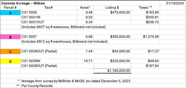
Property Record
159 Us Highway 520, Cusseta, GA 31805
Current Lease Availabilities
NEARBY LISTINGS FOR SALE OR LEASE
-
-
View all Cusseta listings for lease on LoopNet.com
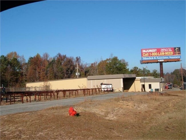
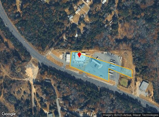
Property Detail
159 Us Highway 520
Conveniencestore
Chattahoochee
X
Georgia
13053C0170C
5.99 AC
2024
Chattahoochee County
2024
Columbus GA
020100
Columbus, GA-AL
12,095 SF
C0050-00000-021-000
DEMOGRAPHICS near 159 Us Highway 520
1 Mile
3 Mile
5 Mile
2024 Total Population
552
1,317
1,788
2029 Population
465
1,109
1,506
Pop Growth 2024-2029
(15.76%)
(15.79%)
(15.77%)
Average Age
42
42
42
2024 Total Households
218
521
706
HH Growth 2024-2029
(18.81%)
(19.00%)
(18.98%)
Median Household Inc
$33,845
$33,437
$34,187
Avg Household Size
2.50
2.50
2.50
2024 Avg HH Vehicles
2.00
2.00
2.00
Median Home Value
$145,652
$146,330
$141,836
Median Year Built
1985
1985
1984
Nearby Places
Map Layers
Map Styles
 Street
 Aerial
- Restaurants
- Banks
- Shops
- Fitness
- Groceries
PUBLIC TRANSPORTATION
AIRPORT
Columbus
DRIVE
WALK
Distance
Columbus
29 min
20.2 mi
Nearby Properties
Address
Land Use
TOTAL SIZE
Lot Size
Zoning
Address
Land Use
TOTAL SIZE
Lot Size
Zoning
148.57 AC
A-1
Address
Land Use
TOTAL SIZE
Lot Size
Zoning
11,000 SF
56.47 AC
A-1
Address
Land Use
TOTAL SIZE
Lot Size
Zoning
3,194 SF
3.19 AC
R-6
Address
Land Use
TOTAL SIZE
Lot Size
Zoning
1,111.56 AC
A-1
Address
Land Use
TOTAL SIZE
Lot Size
Zoning
1,124.23 AC
A-1
Address
Land Use
TOTAL SIZE
Lot Size
Zoning
340.47 AC
R-4
Address
Land Use
TOTAL SIZE
Lot Size
Zoning
10,602 SF
1.76 AC
COM
Address
Land Use
TOTAL SIZE
Lot Size
Zoning
6,535 SF
0.54 AC
PUBLIC
Address
Land Use
TOTAL SIZE
Lot Size
Zoning
2,102 SF
4.33 AC
PUBLIC
Address
Land Use
TOTAL SIZE
Lot Size
Zoning
3,288 SF
2.66 AC
C-1
Address
Land Use
TOTAL SIZE
Lot Size
Zoning
1,820 SF
2.43 AC
001
Address
Land Use
TOTAL SIZE
Lot Size
Zoning
3,040 SF
0.38 AC
R-1
Address
Land Use
TOTAL SIZE
Lot Size
Zoning
7,334 SF
1.09 AC
001
Address
Land Use
TOTAL SIZE
Lot Size
Zoning
332.43 AC
R-5
Address
Land Use
TOTAL SIZE
Lot Size
Zoning
20,000 SF
4 AC
I-1
Address
Land Use
TOTAL SIZE
Lot Size
Zoning
8,000 SF
1.50 AC
C-1
Address
Land Use
TOTAL SIZE
Lot Size
Zoning
335.92 AC
A-1
Address
Land Use
TOTAL SIZE
Lot Size
Zoning
3,249 SF
0.54 AC
002
Address
Land Use
TOTAL SIZE
Lot Size
Zoning
2,961 SF
0.19 AC
PUBLIC
Address
Land Use
TOTAL SIZE
Lot Size
Zoning
2,400 SF
0.55 AC
PUBLIC
Address
Land Use
TOTAL SIZE
Lot Size
Zoning
4,306 SF
0.73 AC
PUBLIC
Address
Land Use
TOTAL SIZE
Lot Size
Zoning
1,681 SF
1.02 AC
003
Address
Land Use
TOTAL SIZE
Lot Size
Zoning
190.21 AC
A-1
Address
Land Use
TOTAL SIZE
Lot Size
Zoning
1,632 SF
48.32 AC
AGR
Address
Land Use
TOTAL SIZE
Lot Size
Zoning
132.21 AC
A-1
Address
Land Use
TOTAL SIZE
Lot Size
Zoning
3,962 SF
108 AC
A-1
Address
Land Use
TOTAL SIZE
Lot Size
Zoning
120.35 AC
A-1
Address
Land Use
TOTAL SIZE
Lot Size
Zoning
3,250 SF
2.17 AC
002
The World's #1 Commercial Real Estate Marketplace
Connect with us
© 2025 CoStar Group
The information above has been obtained from sources believed reliable. While we do not doubt its accuracy we have not verified it and make no guarantee, warranty or representation about it. It is your responsibility to independently confirm its accuracy and completeness. Any projections, opinions, assumptions, or estimates used are for example only and do not represent the current or future performance of the property. The value of this transaction to you depends on tax and other factors which should be evaluated by your tax, financial, and legal advisors. You and your advisors should conduct a careful, independent investigation of the property to determine to your satisfaction the suitability of the property for your needs.