Property Record
159 Wolfpack Rd, Gastonia, NC 28056


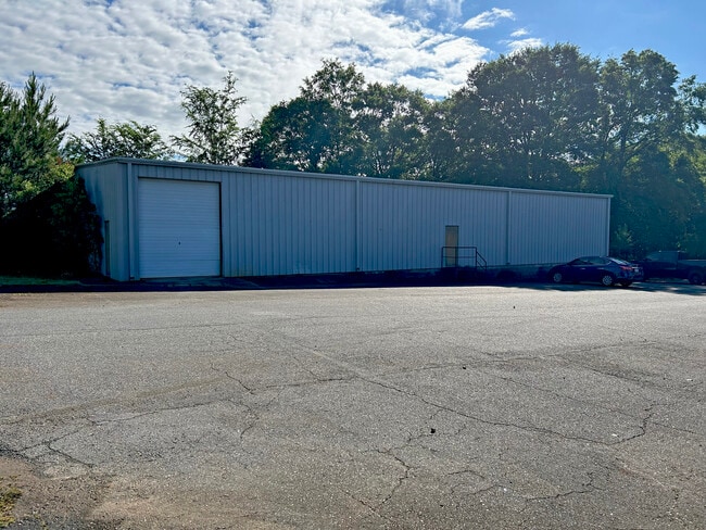
Property Detail
159 Wolfpack Rd
147317
SMITH TEXTILE APRON CO L P11 10 096 004 29 000
Industrialgeneral
GASTON
STOR6
North Carolina
B and X Area of moderate flood hazard, usually the area between the limits of the 100-year and 500-year floods.
4.05 AC
2025
Gaston County
2025
Charlotte
033400
Charlotte-Concord-Gastonia, NC-SC
8,000 SF
NEARBY LISTINGS FOR SALE OR LEASE
DEMOGRAPHICS near 159 Wolfpack Rd
1 mile
3 mile
5 mile
2025 Total Population
947
13,232
56,024
2030 Population
1,016
14,009
59,271
Pop Growth 2025-2030
+ 7.29%
+ 5.87%
+ 5.80%
Average Age
40
41
40
2025 Total Households
372
5,106
21,882
HH Growth 2025-2030
+ 7.80%
+ 6.09%
+ 5.96%
Median Household Inc
$83,382
$80,366
$73,280
Avg Household Size
2.50
2.50
2.50
2025 Avg HH Vehicles
2.00
2.00
2.00
Median Home Value
$238,000
$251,307
$289,529
Median Year Built
1986
1986
1986
Nearby Places
Map Layers
Map Styles
 Street
 Aerial
Layers
 Traffic
 Biking
Places
Listings with unknown addresses are not visible on the map
- Restaurants
- Banks
- Shops
- Fitness
- Groceries
PUBLIC TRANSPORTATION
COMMUTER RAIL
Gastonia Amtrak Station (Crescent - Amtrak)
Drive
Walk
Distance
Gastonia Amtrak Station (Crescent - Amtrak)
14 min
8.2 mi
AIRPORT
Charlotte/Douglas International
Drive
Walk
Distance
Charlotte/Douglas International
40 min
23.8 mi
Freight Ports
North Charleston Terminal
Drive
Walk
Distance
North Charleston Terminal
237 min
203.2 mi
SALE & LEASE HISTORY
LISTING DATE
SALE/LEASE

May 21, 2024
For Sale
Nearby Properties
Address
Land Use
TOTAL SIZE
Lot Size
Zoning
Address
Land Use
TOTAL SIZE
Lot Size
Zoning
199,200 SF
23.83 AC
INDS1
Address
Land Use
TOTAL SIZE
Lot Size
Zoning
2,000 SF
23.89 AC
INDS2
Address
Land Use
TOTAL SIZE
Lot Size
Zoning
2,576 SF
96.39 AC
OFF01
Address
Land Use
TOTAL SIZE
Lot Size
Zoning
65,545 SF
9.81 AC
SHOP1
Address
Land Use
TOTAL SIZE
Lot Size
Zoning
20,290 SF
3.12 AC
Address
Land Use
TOTAL SIZE
Lot Size
Zoning
960 SF
32.54 AC
INDS2
Address
Land Use
TOTAL SIZE
Lot Size
Zoning
22,468 SF
20.75 AC
INDS2
Address
Land Use
TOTAL SIZE
Lot Size
Zoning
192,000 SF
60.46 AC
INDS1
Address
Land Use
TOTAL SIZE
Lot Size
Zoning
10,164 SF
101.07 AC
Address
Land Use
TOTAL SIZE
Lot Size
Zoning
2,491 SF
167.77 AC
R1H
Address
Land Use
TOTAL SIZE
Lot Size
Zoning
96,260 SF
8.50 AC
INDS1
Address
Land Use
TOTAL SIZE
Lot Size
Zoning
30,220 SF
6.78 AC
INDS1
Address
Land Use
TOTAL SIZE
Lot Size
Zoning
3,114 SF
84.06 AC
Address
Land Use
TOTAL SIZE
Lot Size
Zoning
80,960 SF
9.91 AC
INDS2
Address
Land Use
TOTAL SIZE
Lot Size
Zoning
4,738 SF
21.75 AC
R1
Address
Land Use
TOTAL SIZE
Lot Size
Zoning
95,700 SF
4.19 AC
INDS2
Address
Land Use
TOTAL SIZE
Lot Size
Zoning
27,490 SF
4.02 AC
CHUR2
Address
Land Use
TOTAL SIZE
Lot Size
Zoning
15,125 SF
12.15 AC
INDS2
Address
Land Use
TOTAL SIZE
Lot Size
Zoning
5,247 SF
31.01 AC
Address
Land Use
TOTAL SIZE
Lot Size
Zoning
5,400 SF
4.88 AC
STOR4
Address
Land Use
TOTAL SIZE
Lot Size
Zoning
64,619 SF
14.16 AC
INDS2
Address
Land Use
TOTAL SIZE
Lot Size
Zoning
9,656 SF
10 AC
CHUR1
Address
Land Use
TOTAL SIZE
Lot Size
Zoning
36,372 SF
6.08 AC
CHUR2
Address
Land Use
TOTAL SIZE
Lot Size
Zoning
2,238 SF
6.54 AC
Address
Land Use
TOTAL SIZE
Lot Size
Zoning
Address
Land Use
TOTAL SIZE
Lot Size
Zoning
8,180 SF
6.96 AC
CHUR2
Address
Land Use
TOTAL SIZE
Lot Size
Zoning
10,000 SF
8.51 AC
INDS2
Address
Land Use
TOTAL SIZE
Lot Size
Zoning
16,402 SF
12.05 AC
CHUR2
Address
Land Use
TOTAL SIZE
Lot Size
Zoning
144.18 AC
R1
Address
Land Use
TOTAL SIZE
Lot Size
Zoning
113.42 AC
R1
The World's #1 Commercial Real Estate Marketplace
Connect with us
© 2026 CoStar Group
The information above has been obtained from sources believed reliable. While we do not doubt its accuracy we have not verified it and make no guarantee, warranty or representation about it. It is your responsibility to independently confirm its accuracy and completeness. Any projections, opinions, assumptions, or estimates used are for example only and do not represent the current or future performance of the property. The value of this transaction to you depends on tax and other factors which should be evaluated by your tax, financial, and legal advisors. You and your advisors should conduct a careful, independent investigation of the property to determine to your satisfaction the suitability of the property for your needs.