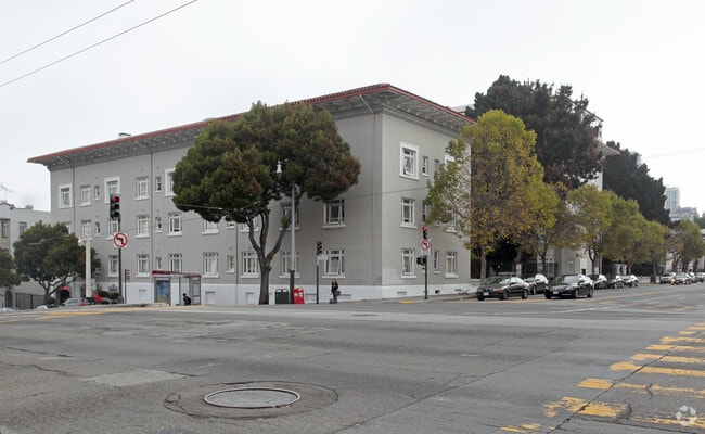
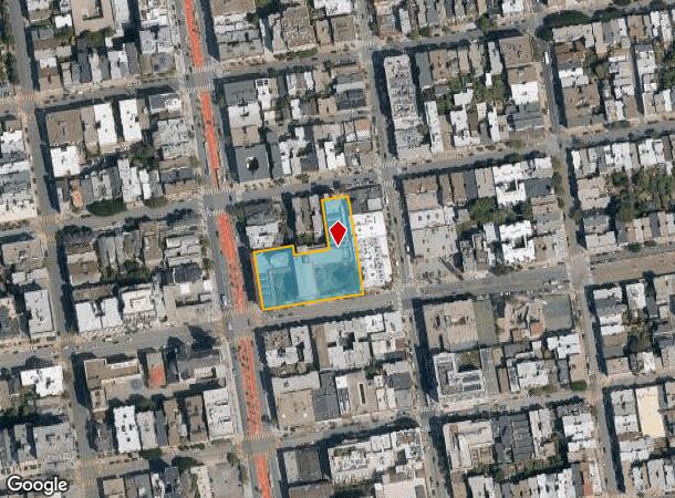
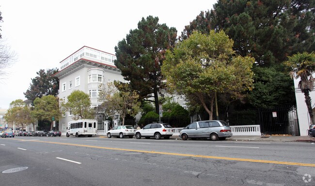
Property Record
1590 Broadway, San Francisco, CA 94109
NEARBY LISTINGS FOR SALE OR LEASE
-
-
View all San Francisco listings for sale on LoopNet.com
Property Detail
1590 Broadway
San Francisco-Redwood City-South San Francisco, CA
Western
0571-005
San Francisco
Apartment
California
2024
5
2025
1.20 AC
010902
Van Ness/Chinatown
113,305 SF
San Francisco
DEMOGRAPHICS near 1590 Broadway
1 Mile
3 Mile
5 Mile
2024 Total Population
123,005
405,284
646,166
2029 Population
114,103
378,009
599,515
Pop Growth 2024-2029
(7.24%)
(6.73%)
(7.22%)
Average Age
44
42
42
2024 Total Households
66,982
199,347
290,857
HH Growth 2024-2029
(7.72%)
(7.27%)
(7.64%)
Median Household Inc
$104,441
$128,095
$131,912
Avg Household Size
1.70
1.90
2.10
2024 Avg HH Vehicles
1.00
1.00
1.00
Median Home Value
$1,091,730
$1,101,225
$1,107,451
Median Year Built
1948
1949
1949
Nearby Places
- Restaurants
- Banks
- Shops
- Fitness
- Groceries
PUBLIC TRANSPORTATION
TRANSIT/SUBWAY
Hyde And Vallejo (Powell-Hyde Cable Car - San Francisco Municipal Railway (MUNI Metro), POWELL-HYDE CABLE CAR - San Francisco Municipal Railway (MUNI Metro))
DRIVE
WALK
Distance
Hyde And Vallejo (Powell-Hyde Cable Car - San Francisco Municipal Railway (MUNI Metro), POWELL-HYDE CABLE CAR - San Francisco Municipal Railway (MUNI Metro))
1 min
5 min
0.3 mi
Hyde And Broadway (Powell-Hyde Cable Car - San Francisco Municipal Railway (MUNI Metro), POWELL-HYDE CABLE CAR - San Francisco Municipal Railway (MUNI Metro))
DRIVE
WALK
Distance
Hyde And Broadway (Powell-Hyde Cable Car - San Francisco Municipal Railway (MUNI Metro), POWELL-HYDE CABLE CAR - San Francisco Municipal Railway (MUNI Metro))
1 min
6 min
0.3 mi
Union And Hyde (Powell-Hyde Cable Car - San Francisco Municipal Railway (MUNI Metro), POWELL-HYDE CABLE CAR - San Francisco Municipal Railway (MUNI Metro))
DRIVE
WALK
Distance
Union And Hyde (Powell-Hyde Cable Car - San Francisco Municipal Railway (MUNI Metro), POWELL-HYDE CABLE CAR - San Francisco Municipal Railway (MUNI Metro))
1 min
7 min
0.4 mi
Jackson And Hyde (Powell-Hyde Cable Car - San Francisco Municipal Railway (MUNI Metro), POWELL-HYDE CABLE CAR - San Francisco Municipal Railway (MUNI Metro))
DRIVE
WALK
Distance
Jackson And Hyde (Powell-Hyde Cable Car - San Francisco Municipal Railway (MUNI Metro), POWELL-HYDE CABLE CAR - San Francisco Municipal Railway (MUNI Metro))
1 min
8 min
0.4 mi
Hyde And Washington (Powell-Hyde Cable Car - San Francisco Municipal Railway (MUNI Metro))
DRIVE
WALK
Distance
Hyde And Washington (Powell-Hyde Cable Car - San Francisco Municipal Railway (MUNI Metro))
1 min
9 min
0.5 mi
COMMUTER RAIL
San Francisco 4Th & King (Caltrain - Caltrain (Caltrain))
DRIVE
WALK
Distance
San Francisco 4Th & King (Caltrain - Caltrain (Caltrain))
7 min
2.6 mi
San Francisco Caltrain Station Southbound (Express - Caltrain (Caltrain), Limited - Caltrain (Caltrain), Local Weekday - Caltrain (Caltrain), Local Weekend - Caltrain (Caltrain))
DRIVE
WALK
Distance
San Francisco Caltrain Station Southbound (Express - Caltrain (Caltrain), Limited - Caltrain (Caltrain), Local Weekday - Caltrain (Caltrain), Local Weekend - Caltrain (Caltrain))
7 min
2.7 mi
AIRPORT
San Francisco International
DRIVE
WALK
Distance
San Francisco International
26 min
15.6 mi
Metro Oakland International
DRIVE
WALK
Distance
Metro Oakland International
32 min
20.6 mi
Freight Ports
Port of San Francisco
DRIVE
WALK
Distance
Port of San Francisco
4 min
1.7 mi
Nearby Properties
Address
Land Use
TOTAL SIZE
Lot Size
Zoning
Address
Land Use
TOTAL SIZE
Lot Size
Zoning
1,015,000 SF
2.43 AC
RC4
Address
Land Use
TOTAL SIZE
Lot Size
Zoning
764,661 SF
0.67 AC
C3OSD
Address
Land Use
TOTAL SIZE
Lot Size
Zoning
750,370 SF
3.25 AC
MBR3
Address
Land Use
TOTAL SIZE
Lot Size
Zoning
1,471,929 SF
1.93 AC
C3O
Address
Land Use
TOTAL SIZE
Lot Size
Zoning
1,300,000 SF
1.74 AC
C3O
Address
Land Use
TOTAL SIZE
Lot Size
Zoning
1,420,430 SF
1.16 AC
C3OSD
Address
Land Use
TOTAL SIZE
Lot Size
Zoning
1,534,312 SF
2.60 AC
C3O
Address
Land Use
TOTAL SIZE
Lot Size
Zoning
914,037 SF
1.36 AC
C3O
Address
Land Use
TOTAL SIZE
Lot Size
Zoning
717,234 SF
3.47 AC
UMU
Address
Land Use
TOTAL SIZE
Lot Size
Zoning
605,459 SF
0.63 AC
C3O
Address
Land Use
TOTAL SIZE
Lot Size
Zoning
475,791 SF
0.55 AC
C3OSD
Address
Land Use
TOTAL SIZE
Lot Size
Zoning
690,442 SF
0.79 AC
C3O
Address
Land Use
TOTAL SIZE
Lot Size
Zoning
10.92 AC
Address
Land Use
TOTAL SIZE
Lot Size
Zoning
750,491 SF
0.51 AC
C3O
Address
Land Use
TOTAL SIZE
Lot Size
Zoning
432,000 SF
0.35 AC
C3OSD
Address
Land Use
TOTAL SIZE
Lot Size
Zoning
266,143 SF
4 AC
C-3-R
Address
Land Use
TOTAL SIZE
Lot Size
Zoning
885,581 SF
5.20 AC
M2
Address
Land Use
TOTAL SIZE
Lot Size
Zoning
512,395 SF
1.24 AC
C3O
Address
Land Use
TOTAL SIZE
Lot Size
Zoning
508,714 SF
1.29 AC
C3R
Address
Land Use
TOTAL SIZE
Lot Size
Zoning
1,084,662 SF
1.67 AC
C3O
Address
Land Use
TOTAL SIZE
Lot Size
Zoning
505,120 SF
0.41 AC
C3O
Address
Land Use
TOTAL SIZE
Lot Size
Zoning
694,334 SF
1.01 AC
C3O
Address
Land Use
TOTAL SIZE
Lot Size
Zoning
696,431 SF
0.97 AC
C3G
Address
Land Use
TOTAL SIZE
Lot Size
Zoning
139,070 SF
0.64 AC
C3O
Address
Land Use
TOTAL SIZE
Lot Size
Zoning
1.52 AC
C3G
Address
Land Use
TOTAL SIZE
Lot Size
Zoning
1,424,230 SF
2.60 AC
C3G
Address
Land Use
TOTAL SIZE
Lot Size
Zoning
614,740 SF
1.74 AC
C3OSD
Address
Land Use
TOTAL SIZE
Lot Size
Zoning
615,957 SF
0.63 AC
C3O
Address
Land Use
TOTAL SIZE
Lot Size
Zoning
492,980 SF
0.43 AC
C3O
Address
Land Use
TOTAL SIZE
Lot Size
Zoning
385,000 SF
0.81 AC
C3O
The World's #1 Commercial Real Estate Marketplace
Connect with us
© 2025 CoStar Group
The information above has been obtained from sources believed reliable. While we do not doubt its accuracy we have not verified it and make no guarantee, warranty or representation about it. It is your responsibility to independently confirm its accuracy and completeness. Any projections, opinions, assumptions, or estimates used are for example only and do not represent the current or future performance of the property. The value of this transaction to you depends on tax and other factors which should be evaluated by your tax, financial, and legal advisors. You and your advisors should conduct a careful, independent investigation of the property to determine to your satisfaction the suitability of the property for your needs.