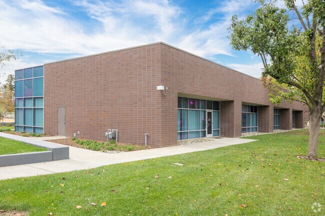
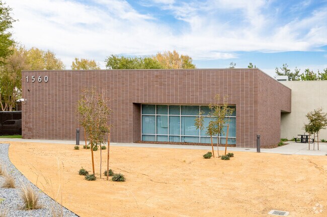
Property Record
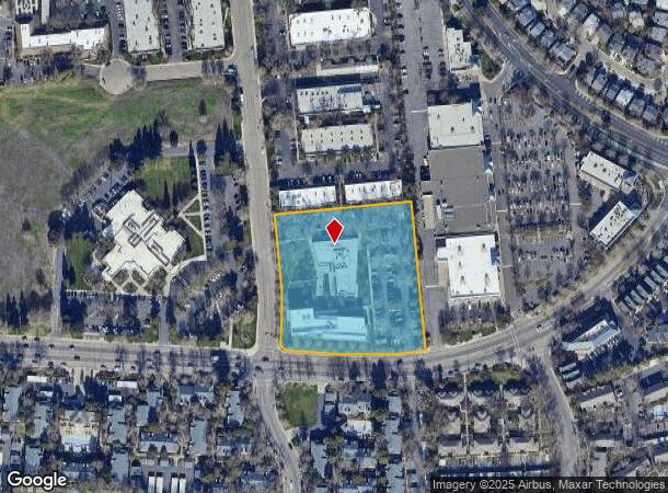
1560 Drew Ave, Davis, CA 95618
NEARBY LISTINGS FOR SALE OR LEASE
Property Detail
1560 Drew Ave
Sacramento-Roseville-Folsom, CA
University Research Park
069-300-012-000
PM3632 PCL B PCL MB 9 PG 18
Officebuilding
Yolo
X
California
06113C0611G
5
2024
3.64 AC
2025
Davis/Woodland
010608
Sacramento
11,804 SF
DEMOGRAPHICS near 1560 Drew Ave
1 mile
3 mile
5 mile
2024 Total Population
15,615
75,398
83,641
2029 Population
15,977
76,735
85,105
Pop Growth 2024-2029
+ 2.32%
+ 1.77%
+ 1.75%
Average Age
32
33
34
2024 Total Households
5,420
25,868
28,977
HH Growth 2024-2029
+ 2.36%
+ 1.88%
+ 1.83%
Median Household Inc
$64,098
$76,880
$77,240
Avg Household Size
2.50
2.50
2.50
2024 Avg HH Vehicles
2.00
2.00
2.00
Median Home Value
$708,581
$795,909
$794,310
Median Year Built
1989
1982
1982
Nearby Places
Map Layers
Map Styles
 Street
 Aerial
Transit
 Traffic
 Biking
Places
Listings with unknown addresses are not visible on the map
- Restaurants
- Banks
- Shops
- Fitness
- Groceries
PUBLIC TRANSPORTATION
COMMUTER RAIL
Davis (California Zephyr - Amtrak, Capitol Corridor - Amtrak, Coast Starlight - Amtrak)
Drive
Walk
Distance
Davis (California Zephyr - Amtrak, Capitol Corridor - Amtrak, Coast Starlight - Amtrak)
3 min
20 min
1.0 mi
AIRPORT
Sacramento International
Drive
Walk
Distance
Sacramento International
30 min
22.2 mi
Freight Ports
Port of Stockton
Drive
Walk
Distance
Port of Stockton
68 min
58.2 mi
SALE & LEASE HISTORY
LISTING DATE
SALE/LEASE

Jan 17, 2019
For Lease
Nearby Properties
Address
Land Use
TOTAL SIZE
Lot Size
Zoning
Address
Land Use
TOTAL SIZE
Lot Size
Zoning
11.18 AC
P-D
Address
Land Use
TOTAL SIZE
Lot Size
Zoning
40,000 SF
16.56 AC
A1
Address
Land Use
TOTAL SIZE
Lot Size
Zoning
5.92 AC
P-D
Address
Land Use
TOTAL SIZE
Lot Size
Zoning
29,376 SF
0.14 AC
PD
Address
Land Use
TOTAL SIZE
Lot Size
Zoning
225,000 SF
7.43 AC
PD
Address
Land Use
TOTAL SIZE
Lot Size
Zoning
185,271 SF
1.01 AC
RHD
Address
Land Use
TOTAL SIZE
Lot Size
Zoning
0.20 AC
I
Address
Land Use
TOTAL SIZE
Lot Size
Zoning
209,988 SF
0.11 AC
PD
Address
Land Use
TOTAL SIZE
Lot Size
Zoning
168,279 SF
0.09 AC
R-M
Address
Land Use
TOTAL SIZE
Lot Size
Zoning
110,839 SF
0.26 AC
R3M
Address
Land Use
TOTAL SIZE
Lot Size
Zoning
134,214 SF
5.99 AC
PD
Address
Land Use
TOTAL SIZE
Lot Size
Zoning
174,228 SF
0.16 AC
PD
Address
Land Use
TOTAL SIZE
Lot Size
Zoning
4.40 AC
PD
Address
Land Use
TOTAL SIZE
Lot Size
Zoning
126,842 SF
13.56 AC
PD
Address
Land Use
TOTAL SIZE
Lot Size
Zoning
148,848 SF
0.13 AC
I
Address
Land Use
TOTAL SIZE
Lot Size
Zoning
107,817 SF
6.44 AC
PD
Address
Land Use
TOTAL SIZE
Lot Size
Zoning
1.37 AC
PD
Address
Land Use
TOTAL SIZE
Lot Size
Zoning
2.52 AC
I
Address
Land Use
TOTAL SIZE
Lot Size
Zoning
99,399 SF
5.83 AC
I
Address
Land Use
TOTAL SIZE
Lot Size
Zoning
152,916 SF
0.17 AC
PD
Address
Land Use
TOTAL SIZE
Lot Size
Zoning
13,068 SF
8.25 AC
PD
Address
Land Use
TOTAL SIZE
Lot Size
Zoning
1.74 AC
CH
Address
Land Use
TOTAL SIZE
Lot Size
Zoning
68,428 SF
0.29 AC
PD
Address
Land Use
TOTAL SIZE
Lot Size
Zoning
213,692 SF
8.07 AC
03
Address
Land Use
TOTAL SIZE
Lot Size
Zoning
102,400 SF
5.78 AC
PD
Address
Land Use
TOTAL SIZE
Lot Size
Zoning
90,752 SF
0.21 AC
R3
Address
Land Use
TOTAL SIZE
Lot Size
Zoning
1.93 AC
PD
Address
Land Use
TOTAL SIZE
Lot Size
Zoning
78,953 SF
2.69 AC
I
Address
Land Use
TOTAL SIZE
Lot Size
Zoning
61,829 SF
1.31 AC
CC
Address
Land Use
TOTAL SIZE
Lot Size
Zoning
12,361 SF
0.59 AC
PD
The World's #1 Commercial Real Estate Marketplace
Connect with us
© 2026 CoStar Group
The information above has been obtained from sources believed reliable. While we do not doubt its accuracy we have not verified it and make no guarantee, warranty or representation about it. It is your responsibility to independently confirm its accuracy and completeness. Any projections, opinions, assumptions, or estimates used are for example only and do not represent the current or future performance of the property. The value of this transaction to you depends on tax and other factors which should be evaluated by your tax, financial, and legal advisors. You and your advisors should conduct a careful, independent investigation of the property to determine to your satisfaction the suitability of the property for your needs.