Property Record
1590 E State Route 15, Belleville, IL 62221
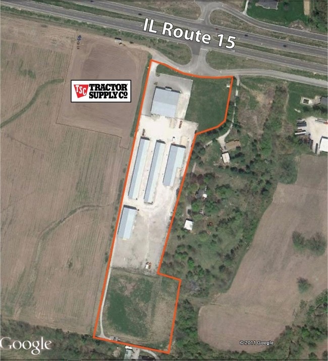

Property Detail
1590 E State Route 15
St. Louis, MO-IL
SURVEY 382 EXC PT FOR HWY A02302143
13-01.0-400-025
Saint Clair
Commercialnec
Illinois
2024
11.38 AC
2024
Illinois
503903
St. Louis
15,000 SF
NEARBY LISTINGS FOR SALE OR LEASE
-
-
View all Belleville listings for sale on LoopNet.com
DEMOGRAPHICS near 1590 E State Route 15
1 mile
3 mile
5 mile
2025 Total Population
673
9,267
45,167
2030 Population
648
9,007
44,324
Pop Growth 2025-2030
(3.71%)
(2.81%)
(1.87%)
Average Age
43
40
40
2025 Total Households
235
3,502
18,188
HH Growth 2025-2030
(3.83%)
(2.80%)
(1.87%)
Median Household Inc
$145,312
$87,799
$71,491
Avg Household Size
2.70
2.60
2.40
2025 Avg HH Vehicles
3.00
2.00
2.00
Median Home Value
$354,945
$230,203
$182,412
Median Year Built
1994
1984
1974
Nearby Places
Map Layers
Map Styles
 Street
 Aerial
Layers
 Traffic
 Biking
Places
Listings with unknown addresses are not visible on the map
- Restaurants
- Banks
- Shops
- Fitness
- Groceries
PUBLIC TRANSPORTATION
COMMUTER RAIL
College (Lambert Airport Shiloh-Scott - St. Louis MetroLink (MetroLink))
Drive
Walk
Distance
College (Lambert Airport Shiloh-Scott - St. Louis MetroLink (MetroLink))
11 min
4.4 mi
Belleville (Lambert Airport Shiloh-Scott - St. Louis MetroLink (MetroLink))
Drive
Walk
Distance
Belleville (Lambert Airport Shiloh-Scott - St. Louis MetroLink (MetroLink))
10 min
5.9 mi
AIRPORT
Scott AFB/Midamerica St Louis
Drive
Walk
Distance
Scott AFB/Midamerica St Louis
25 min
11.5 mi
St Louis Lambert International
Drive
Walk
Distance
St Louis Lambert International
45 min
32.5 mi
Nearby Properties
Address
Land Use
TOTAL SIZE
Lot Size
Zoning
Address
Land Use
TOTAL SIZE
Lot Size
Zoning
9,600 SF
8.59 AC
Address
Land Use
TOTAL SIZE
Lot Size
Zoning
19,576 SF
22.78 AC
Address
Land Use
TOTAL SIZE
Lot Size
Zoning
155,488 SF
16.54 AC
Address
Land Use
TOTAL SIZE
Lot Size
Zoning
30,000 SF
9.05 AC
Address
Land Use
TOTAL SIZE
Lot Size
Zoning
61,340 SF
16.33 AC
Address
Land Use
TOTAL SIZE
Lot Size
Zoning
48,700 SF
3.29 AC
Address
Land Use
TOTAL SIZE
Lot Size
Zoning
8,648 SF
5.75 AC
Address
Land Use
TOTAL SIZE
Lot Size
Zoning
40,400 SF
2.52 AC
Address
Land Use
TOTAL SIZE
Lot Size
Zoning
8,388 SF
2.90 AC
Address
Land Use
TOTAL SIZE
Lot Size
Zoning
21,120 SF
3.94 AC
Address
Land Use
TOTAL SIZE
Lot Size
Zoning
5,880 SF
28.39 AC
Address
Land Use
TOTAL SIZE
Lot Size
Zoning
37,532 SF
8.41 AC
Address
Land Use
TOTAL SIZE
Lot Size
Zoning
16,060 SF
11.86 AC
Address
Land Use
TOTAL SIZE
Lot Size
Zoning
38,500 SF
3.94 AC
Address
Land Use
TOTAL SIZE
Lot Size
Zoning
19,120 SF
3.45 AC
Address
Land Use
TOTAL SIZE
Lot Size
Zoning
12,904 SF
6.26 AC
Address
Land Use
TOTAL SIZE
Lot Size
Zoning
Address
Land Use
TOTAL SIZE
Lot Size
Zoning
10,800 SF
4.61 AC
Address
Land Use
TOTAL SIZE
Lot Size
Zoning
7,814 SF
0.83 AC
Address
Land Use
TOTAL SIZE
Lot Size
Zoning
9,191 SF
1.21 AC
Address
Land Use
TOTAL SIZE
Lot Size
Zoning
4,260 SF
1.49 AC
Address
Land Use
TOTAL SIZE
Lot Size
Zoning
3,126 SF
0.80 AC
Address
Land Use
TOTAL SIZE
Lot Size
Zoning
1.63 AC
Address
Land Use
TOTAL SIZE
Lot Size
Zoning
51,552 SF
2.97 AC
Address
Land Use
TOTAL SIZE
Lot Size
Zoning
5.85 AC
Address
Land Use
TOTAL SIZE
Lot Size
Zoning
13.62 AC
Address
Land Use
TOTAL SIZE
Lot Size
Zoning
29,400 SF
3.18 AC
Address
Land Use
TOTAL SIZE
Lot Size
Zoning
3,824 SF
1.64 AC
Address
Land Use
TOTAL SIZE
Lot Size
Zoning
2,961 SF
9.92 AC
The World's #1 Commercial Real Estate Marketplace
Connect with us
© 2026 CoStar Group
The information above has been obtained from sources believed reliable. While we do not doubt its accuracy we have not verified it and make no guarantee, warranty or representation about it. It is your responsibility to independently confirm its accuracy and completeness. Any projections, opinions, assumptions, or estimates used are for example only and do not represent the current or future performance of the property. The value of this transaction to you depends on tax and other factors which should be evaluated by your tax, financial, and legal advisors. You and your advisors should conduct a careful, independent investigation of the property to determine to your satisfaction the suitability of the property for your needs.