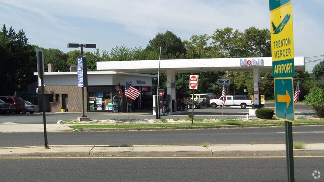
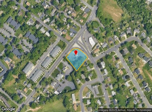
Property Record
1590 Parkside Ave, Ewing, NJ 08638
NEARBY LISTINGS FOR SALE OR LEASE
Property Detail
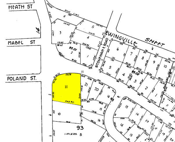
1590 Parkside Ave
02-00093-0000-00011
ADDITIONAL LOTS: CORNER OF SPRUCE
Vacantlandnec
Mercer
X
New Jersey
34021C0119F
11
2024
0.90 AC
2025
Trenton
003500
Northern New Jersey
1,544 SF
Trenton, NJ
DEMOGRAPHICS near 1590 Parkside Ave
1 Mile
3 Mile
5 Mile
2024 Total Population
9,576
112,828
239,081
2029 Population
9,544
111,957
236,152
Pop Growth 2024-2029
(0.33%)
(0.77%)
(1.23%)
Average Age
42
40
40
2024 Total Households
3,761
42,055
88,048
HH Growth 2024-2029
(0.64%)
(0.85%)
(1.27%)
Median Household Inc
$75,498
$64,637
$74,082
Avg Household Size
2.50
2.50
2.60
2024 Avg HH Vehicles
2.00
2.00
2.00
Median Home Value
$200,429
$222,645
$268,763
Median Year Built
1959
1955
1957
Nearby Places
Map Layers
Map Styles
 Street
 Aerial
- Restaurants
- Banks
- Shops
- Fitness
- Groceries
PUBLIC TRANSPORTATION
COMMUTER RAIL
Trenton Transit Center (Trenton Line - SEPTA)
DRIVE
WALK
Distance
Trenton Transit Center (Trenton Line - SEPTA)
7 min
3.8 mi
Trenton Transit Center (Njt) (Northeast Corridor Line - NJ Transit Commuter Rail (NJ Transit), R7 - NJ Transit Commuter Rail (NJ Transit), River LINE - NJ Transit Commuter Rail (NJ Transit))
DRIVE
WALK
Distance
Trenton Transit Center (Njt) (Northeast Corridor Line - NJ Transit Commuter Rail (NJ Transit), R7 - NJ Transit Commuter Rail (NJ Transit), River LINE - NJ Transit Commuter Rail (NJ Transit))
9 min
4.0 mi
AIRPORT
Trenton Mercer
DRIVE
WALK
Distance
Trenton Mercer
10 min
4.9 mi
Freight Ports
Port of Philadelphia
DRIVE
WALK
Distance
Port of Philadelphia
47 min
31.1 mi
Nearby Properties
Address
Land Use
TOTAL SIZE
Lot Size
Zoning
Address
Land Use
TOTAL SIZE
Lot Size
Zoning
67.65 AC
R-1
Address
Land Use
TOTAL SIZE
Lot Size
Zoning
8.23 AC
BA
Address
Land Use
TOTAL SIZE
Lot Size
Zoning
26 AC
HIST
Address
Land Use
TOTAL SIZE
Lot Size
Zoning
141.90 AC
EGI
Address
Land Use
TOTAL SIZE
Lot Size
Zoning
1,996 SF
125 AC
RA
Address
Land Use
TOTAL SIZE
Lot Size
Zoning
5.97 AC
R-1
Address
Land Use
TOTAL SIZE
Lot Size
Zoning
879,376 SF
2.54 AC
BA
Address
Land Use
TOTAL SIZE
Lot Size
Zoning
4,320 SF
12.06 AC
PRO
Address
Land Use
TOTAL SIZE
Lot Size
Zoning
125,000 SF
3.68 AC
MU
Address
Land Use
TOTAL SIZE
Lot Size
Zoning
96.60 AC
OP-2
Address
Land Use
TOTAL SIZE
Lot Size
Zoning
117.50 AC
OP-1
Address
Land Use
TOTAL SIZE
Lot Size
Zoning
42.80 AC
IP-1
Address
Land Use
TOTAL SIZE
Lot Size
Zoning
5.38 AC
MU
Address
Land Use
TOTAL SIZE
Lot Size
Zoning
Address
Land Use
TOTAL SIZE
Lot Size
Zoning
27.21 AC
PRO
Address
Land Use
TOTAL SIZE
Lot Size
Zoning
288,000 SF
1.23 AC
BA
Address
Land Use
TOTAL SIZE
Lot Size
Zoning
6.11 AC
R-1
Address
Land Use
TOTAL SIZE
Lot Size
Zoning
35.83 AC
RB
Address
Land Use
TOTAL SIZE
Lot Size
Zoning
56.45 AC
EGI
Address
Land Use
TOTAL SIZE
Lot Size
Zoning
0.24 AC
BA
Address
Land Use
TOTAL SIZE
Lot Size
Zoning
186,960 SF
2.37 AC
BA
Address
Land Use
TOTAL SIZE
Lot Size
Zoning
24.44 AC
AT
Address
Land Use
TOTAL SIZE
Lot Size
Zoning
212,074 SF
0.82 AC
BA
Address
Land Use
TOTAL SIZE
Lot Size
Zoning
23.50 AC
R-2
Address
Land Use
TOTAL SIZE
Lot Size
Zoning
Address
Land Use
TOTAL SIZE
Lot Size
Zoning
323,087 SF
1.95 AC
PM
Address
Land Use
TOTAL SIZE
Lot Size
Zoning
161,080 SF
2.21 AC
BA
Address
Land Use
TOTAL SIZE
Lot Size
Zoning
11.40 AC
Address
Land Use
TOTAL SIZE
Lot Size
Zoning
21.19 AC
B-H
Address
Land Use
TOTAL SIZE
Lot Size
Zoning
4.23 AC
R-1
The World's #1 Commercial Real Estate Marketplace
Connect with us
© 2025 CoStar Group
The information above has been obtained from sources believed reliable. While we do not doubt its accuracy we have not verified it and make no guarantee, warranty or representation about it. It is your responsibility to independently confirm its accuracy and completeness. Any projections, opinions, assumptions, or estimates used are for example only and do not represent the current or future performance of the property. The value of this transaction to you depends on tax and other factors which should be evaluated by your tax, financial, and legal advisors. You and your advisors should conduct a careful, independent investigation of the property to determine to your satisfaction the suitability of the property for your needs.