Property Record
1590 Reed Rd, Pennington, NJ 08534
NEARBY LISTINGS FOR SALE OR LEASE
Property Detail
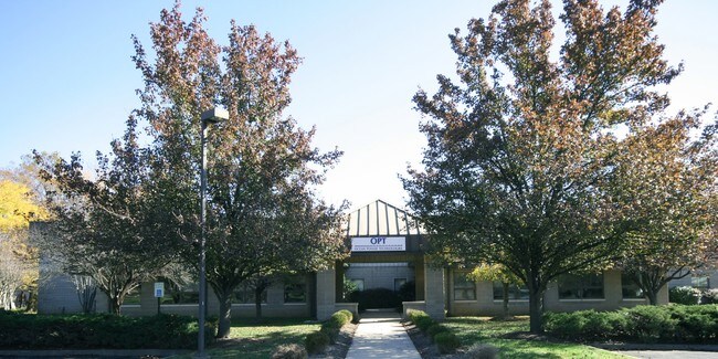
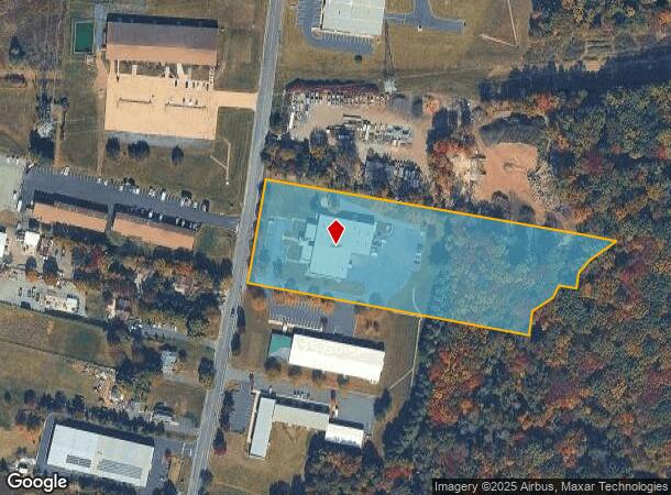
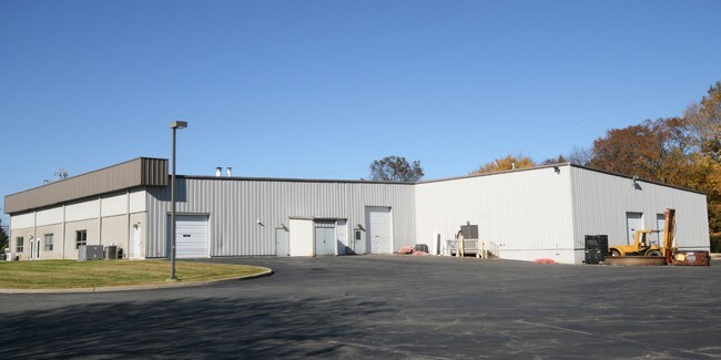
1590 Reed Rd
Trenton, NJ
Reed Road Industrial Park Reed Road
06-00088-0000-00033-01
FACILITY NAME: ADMINISTRATIVE BLDG.
Warehouse
Mercer
X
New Jersey
34021C0116F
33.1
0
5.34 AC
2025
Trenton/295
003800
Northern New Jersey
DEMOGRAPHICS near 1590 Reed Rd
1 Mile
3 Mile
5 Mile
2024 Total Population
1,849
37,094
113,251
2029 Population
1,817
36,737
112,358
Pop Growth 2024-2029
(1.73%)
(0.96%)
(0.79%)
Average Age
44
42
42
2024 Total Households
784
13,864
43,682
HH Growth 2024-2029
(1.91%)
(1.07%)
(0.91%)
Median Household Inc
$122,234
$104,861
$89,040
Avg Household Size
2.30
2.40
2.40
2024 Avg HH Vehicles
2.00
2.00
2.00
Median Home Value
$361,267
$337,544
$323,637
Median Year Built
1989
1976
1963
Nearby Places
Map Layers
Map Styles
 Street
 Aerial
- Restaurants
- Banks
- Shops
- Fitness
- Groceries
PUBLIC TRANSPORTATION
COMMUTER RAIL
West Trenton (R3 - Southeastern Pennsylvania Transportation Authority Regional Rail (SEPTA Regional Rail))
DRIVE
WALK
Distance
West Trenton (R3 - Southeastern Pennsylvania Transportation Authority Regional Rail (SEPTA Regional Rail))
10 min
4.4 mi
DRIVE
WALK
Distance
15 min
6.9 mi
AIRPORT
Trenton Mercer
DRIVE
WALK
Distance
Trenton Mercer
11 min
4.6 mi
Philadelphia International
DRIVE
WALK
Distance
Philadelphia International
69 min
46.9 mi
Freight Ports
Port of Philadelphia
DRIVE
WALK
Distance
Port of Philadelphia
49 min
33.3 mi
SALE & LEASE HISTORY
LISTING DATE
SALE/LEASE

Sep 12, 2017
For Sale
Oct 17, 2019
For Sale
Nov 01, 2016
For Sale
Mar 14, 2017
For Sale
Aug 15, 2017
For Sale
Apr 13, 2017
For Sale
Apr 06, 2017
For Sale
Apr 05, 2017
For Sale
Apr 04, 2017
For Sale
Nearby Properties
Address
Land Use
TOTAL SIZE
Lot Size
Zoning
Address
Land Use
TOTAL SIZE
Lot Size
Zoning
67.65 AC
R-1
Address
Land Use
TOTAL SIZE
Lot Size
Zoning
225.40 AC
R-1
Address
Land Use
TOTAL SIZE
Lot Size
Zoning
5.97 AC
R-1
Address
Land Use
TOTAL SIZE
Lot Size
Zoning
2,464 SF
92.96 AC
RO2
Address
Land Use
TOTAL SIZE
Lot Size
Zoning
4,320 SF
12.06 AC
PRO
Address
Land Use
TOTAL SIZE
Lot Size
Zoning
13.86 AC
OP
Address
Land Use
TOTAL SIZE
Lot Size
Zoning
42.80 AC
IP-1
Address
Land Use
TOTAL SIZE
Lot Size
Zoning
13.36 AC
OP
Address
Land Use
TOTAL SIZE
Lot Size
Zoning
27.21 AC
PRO
Address
Land Use
TOTAL SIZE
Lot Size
Zoning
0.35 AC
OP
Address
Land Use
TOTAL SIZE
Lot Size
Zoning
6.11 AC
R-1
Address
Land Use
TOTAL SIZE
Lot Size
Zoning
104.60 AC
IP-1
Address
Land Use
TOTAL SIZE
Lot Size
Zoning
7.85 AC
OP
Address
Land Use
TOTAL SIZE
Lot Size
Zoning
24.44 AC
AT
Address
Land Use
TOTAL SIZE
Lot Size
Zoning
6.09 AC
OP
Address
Land Use
TOTAL SIZE
Lot Size
Zoning
8.73 AC
OP
Address
Land Use
TOTAL SIZE
Lot Size
Zoning
Address
Land Use
TOTAL SIZE
Lot Size
Zoning
38.82 AC
R100
Address
Land Use
TOTAL SIZE
Lot Size
Zoning
0.32 AC
OP
Address
Land Use
TOTAL SIZE
Lot Size
Zoning
11.40 AC
Address
Land Use
TOTAL SIZE
Lot Size
Zoning
4.23 AC
R-1
Address
Land Use
TOTAL SIZE
Lot Size
Zoning
Address
Land Use
TOTAL SIZE
Lot Size
Zoning
8.93 AC
Address
Land Use
TOTAL SIZE
Lot Size
Zoning
6.37 AC
OP
Address
Land Use
TOTAL SIZE
Lot Size
Zoning
34.70 AC
R-1
Address
Land Use
TOTAL SIZE
Lot Size
Zoning
11.09 AC
Address
Land Use
TOTAL SIZE
Lot Size
Zoning
26.20 AC
OP-1
Address
Land Use
TOTAL SIZE
Lot Size
Zoning
8.35 AC
OP
Address
Land Use
TOTAL SIZE
Lot Size
Zoning
6.01 AC
OP
Address
Land Use
TOTAL SIZE
Lot Size
Zoning
1.30 AC
The World's #1 Commercial Real Estate Marketplace
Connect with us
© 2025 CoStar Group
The information above has been obtained from sources believed reliable. While we do not doubt its accuracy we have not verified it and make no guarantee, warranty or representation about it. It is your responsibility to independently confirm its accuracy and completeness. Any projections, opinions, assumptions, or estimates used are for example only and do not represent the current or future performance of the property. The value of this transaction to you depends on tax and other factors which should be evaluated by your tax, financial, and legal advisors. You and your advisors should conduct a careful, independent investigation of the property to determine to your satisfaction the suitability of the property for your needs.