Property Record
15900 Sabra Way, South Chesterfield, VA 23834

NEARBY LISTINGS FOR SALE OR LEASE
Property Detail
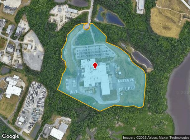
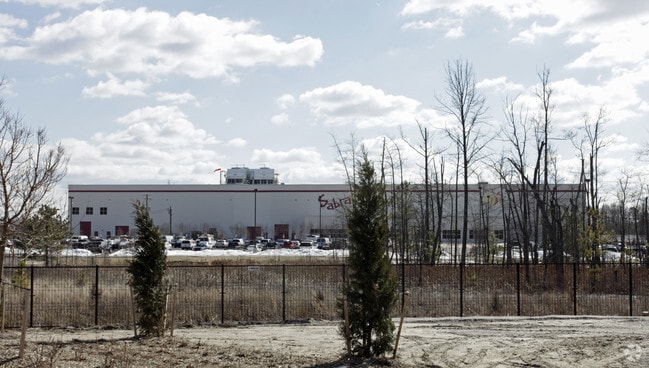
15900 Sabra Way
810-63-53-79-400-000
Terminus Of Port Walthall Ct
Heavymanufacturing
TERMINUS OF PORT WALTHALL CT
X
Chesterfield
51041C0365E
Virginia
0
47.75 AC
2025
I-95 S/I-295 S/Rt 10
100509
Richmond VA
89,260 SF
Richmond, VA
DEMOGRAPHICS near 15900 Sabra Way
1 Mile
3 Mile
5 Mile
2024 Total Population
140
29,587
98,817
2029 Population
150
31,058
103,234
Pop Growth 2024-2029
+ 7.14%
+ 4.97%
+ 4.47%
Average Age
42
40
39
2024 Total Households
49
9,710
34,958
HH Growth 2024-2029
+ 8.16%
+ 5.33%
+ 4.65%
Median Household Inc
$118,749
$79,987
$66,945
Avg Household Size
2.70
2.60
2.50
2024 Avg HH Vehicles
3.00
2.00
2.00
Median Home Value
$327,778
$243,015
$224,157
Median Year Built
1989
1986
1980
Nearby Places
- Restaurants
- Banks
- Shops
- Fitness
- Groceries
PUBLIC TRANSPORTATION
AIRPORT
Richmond International
DRIVE
WALK
Distance
Richmond International
30 min
21.6 mi
Freight Ports
Virginia Port Authority - Richmond
DRIVE
WALK
Distance
Virginia Port Authority - Richmond
1 min
11.0 mi
Nearby Properties
Address
Land Use
TOTAL SIZE
Lot Size
Zoning
Address
Land Use
TOTAL SIZE
Lot Size
Zoning
549.22 AC
A1
Address
Land Use
TOTAL SIZE
Lot Size
Zoning
107.29 AC
Address
Land Use
TOTAL SIZE
Lot Size
Zoning
440,100 SF
82.70 AC
I2 - GEN I
Address
Land Use
TOTAL SIZE
Lot Size
Zoning
505,068 SF
60.92 AC
I2 - GEN I
Address
Land Use
TOTAL SIZE
Lot Size
Zoning
806,770 SF
129.28 AC
I2 - GEN I
Address
Land Use
TOTAL SIZE
Lot Size
Zoning
24,440 SF
16.58 AC
C4 - REGIO
Address
Land Use
TOTAL SIZE
Lot Size
Zoning
482,476 SF
19.75 AC
I2 - GEN I
Address
Land Use
TOTAL SIZE
Lot Size
Zoning
296,000 SF
42.39 AC
I2 - GEN I
Address
Land Use
TOTAL SIZE
Lot Size
Zoning
241,800 SF
16.96 AC
I2 - GEN I
Address
Land Use
TOTAL SIZE
Lot Size
Zoning
287,313 SF
17.26 AC
I1 - LT IN
Address
Land Use
TOTAL SIZE
Lot Size
Zoning
261,922 SF
19.85 AC
I1 - LT IN
Address
Land Use
TOTAL SIZE
Lot Size
Zoning
260,928 SF
19.40 AC
I1 - LT IN
Address
Land Use
TOTAL SIZE
Lot Size
Zoning
194,000 SF
175.55 AC
I1 - LT IN
Address
Land Use
TOTAL SIZE
Lot Size
Zoning
173,800 SF
15.99 AC
I2 - GEN I
Address
Land Use
TOTAL SIZE
Lot Size
Zoning
69,048 SF
16 AC
R7 - SINGL
Address
Land Use
TOTAL SIZE
Lot Size
Zoning
92,905 SF
49.45 AC
A - AGRICU
Address
Land Use
TOTAL SIZE
Lot Size
Zoning
132,121 SF
61.15 AC
I2 - GEN I
Address
Land Use
TOTAL SIZE
Lot Size
Zoning
31,800 SF
21 AC
I2 - GEN I
Address
Land Use
TOTAL SIZE
Lot Size
Zoning
130,698 SF
10.78 AC
PUD
Address
Land Use
TOTAL SIZE
Lot Size
Zoning
140,000 SF
1 AC
999
Address
Land Use
TOTAL SIZE
Lot Size
Zoning
0.01 AC
MH1 - MOBI
Address
Land Use
TOTAL SIZE
Lot Size
Zoning
129,600 SF
12.21 AC
PUD
Address
Land Use
TOTAL SIZE
Lot Size
Zoning
218,821 SF
11.47 AC
I1 - LT IN
Address
Land Use
TOTAL SIZE
Lot Size
Zoning
186,837 SF
26.82 AC
I2 - GEN I
Address
Land Use
TOTAL SIZE
Lot Size
Zoning
56 AC
I2 - GEN I
Address
Land Use
TOTAL SIZE
Lot Size
Zoning
56 AC
I2 - GEN I
Address
Land Use
TOTAL SIZE
Lot Size
Zoning
50,552 SF
9.33 AC
C5 - GEN B
Address
Land Use
TOTAL SIZE
Lot Size
Zoning
220,009 SF
66.16 AC
I2 - GEN I
Address
Land Use
TOTAL SIZE
Lot Size
Zoning
170,700 SF
10.22 AC
I1 - LT IN
The World's #1 Commercial Real Estate Marketplace
Connect with us
© 2025 CoStar Group
The information above has been obtained from sources believed reliable. While we do not doubt its accuracy we have not verified it and make no guarantee, warranty or representation about it. It is your responsibility to independently confirm its accuracy and completeness. Any projections, opinions, assumptions, or estimates used are for example only and do not represent the current or future performance of the property. The value of this transaction to you depends on tax and other factors which should be evaluated by your tax, financial, and legal advisors. You and your advisors should conduct a careful, independent investigation of the property to determine to your satisfaction the suitability of the property for your needs.