Property Record
15916 S Union Ave, Glenpool, OK 74033
NEARBY LISTINGS FOR SALE OR LEASE
-
-
View all Glenpool listings for sale on LoopNet.com
Property Detail
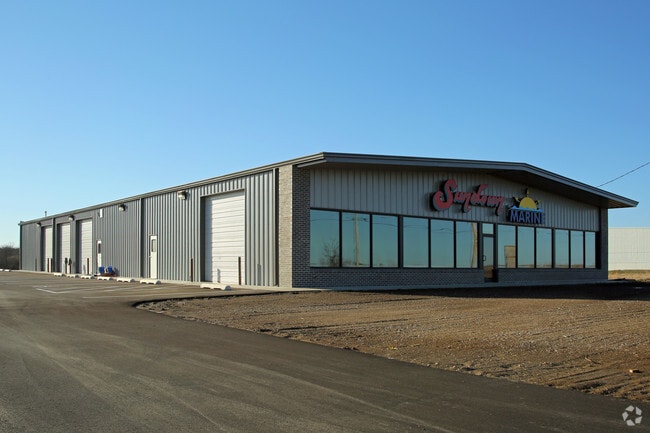
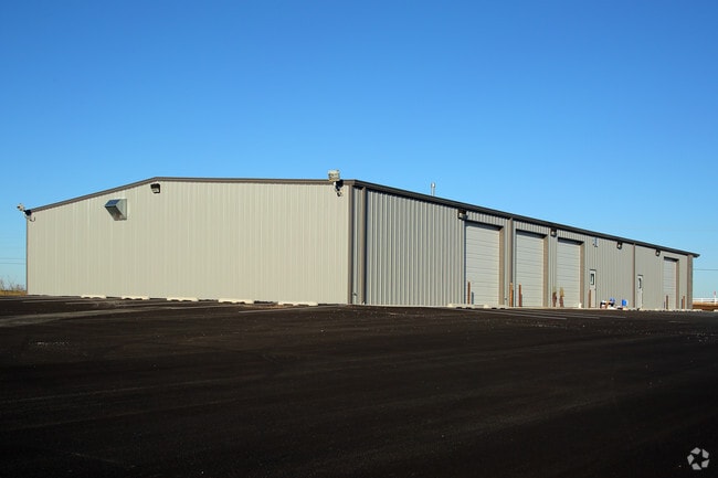
15916 S Union Ave
Tulsa, OK
Southside Industrial Park Ii
85363-72-22-54170
LOT 1 BLOCK 1
Vehiclerentalsvehiclesales
Tulsa
A
Oklahoma
40143C0420K
1
2025
5.82 AC
2025
South Tulsa
007705
Tulsa
9,800 SF
DEMOGRAPHICS near 15916 S Union Ave
1 Mile
3 Mile
5 Mile
2024 Total Population
712
15,044
38,181
2029 Population
730
15,456
39,429
Pop Growth 2024-2029
+ 2.53%
+ 2.74%
+ 3.27%
Average Age
36
36
36
2024 Total Households
248
5,261
12,970
HH Growth 2024-2029
+ 2.42%
+ 2.79%
+ 3.28%
Median Household Inc
$112,222
$74,906
$88,856
Avg Household Size
2.90
2.80
2.90
2024 Avg HH Vehicles
2.00
2.00
2.00
Median Home Value
$266,101
$184,611
$243,638
Median Year Built
2001
1992
2001
Nearby Places
Map Layers
Map Styles
 Street
 Aerial
- Restaurants
- Banks
- Shops
- Fitness
- Groceries
PUBLIC TRANSPORTATION
AIRPORT
Tulsa International
DRIVE
WALK
Distance
Tulsa International
35 min
25.0 mi
Freight Ports
Tulsa Port Of Catoosa
DRIVE
WALK
Distance
Tulsa Port Of Catoosa
43 min
33.7 mi
Nearby Properties
Address
Land Use
TOTAL SIZE
Lot Size
Zoning
Address
Land Use
TOTAL SIZE
Lot Size
Zoning
52,441 SF
12.79 AC
CS
Address
Land Use
TOTAL SIZE
Lot Size
Zoning
49,735 SF
14.35 AC
CG
Address
Land Use
TOTAL SIZE
Lot Size
Zoning
116,016 SF
54.80 AC
CG
Address
Land Use
TOTAL SIZE
Lot Size
Zoning
28,761 SF
9.71 AC
RS1
Address
Land Use
TOTAL SIZE
Lot Size
Zoning
6,702 SF
3.63 AC
AG
Address
Land Use
TOTAL SIZE
Lot Size
Zoning
25,932 SF
15 AC
RE
Address
Land Use
TOTAL SIZE
Lot Size
Zoning
18,560 SF
10.28 AC
AG
Address
Land Use
TOTAL SIZE
Lot Size
Zoning
38,476 SF
18.68 AC
CG
Address
Land Use
TOTAL SIZE
Lot Size
Zoning
68,298 SF
28.61 AC
CG
Address
Land Use
TOTAL SIZE
Lot Size
Zoning
18,078 SF
14.73 AC
IL
Address
Land Use
TOTAL SIZE
Lot Size
Zoning
27.87 AC
IM
Address
Land Use
TOTAL SIZE
Lot Size
Zoning
22.20 AC
AG
Address
Land Use
TOTAL SIZE
Lot Size
Zoning
16,068 SF
0.80 AC
CG
Address
Land Use
TOTAL SIZE
Lot Size
Zoning
32,408 SF
6.25 AC
AG
Address
Land Use
TOTAL SIZE
Lot Size
Zoning
15,097 SF
4.43 AC
RE
Address
Land Use
TOTAL SIZE
Lot Size
Zoning
5,920 SF
7.67 AC
AG
Address
Land Use
TOTAL SIZE
Lot Size
Zoning
36.56 AC
AG
Address
Land Use
TOTAL SIZE
Lot Size
Zoning
33,128 SF
1.83 AC
RM2
Address
Land Use
TOTAL SIZE
Lot Size
Zoning
107,943 SF
8.49 AC
PUD
Address
Land Use
TOTAL SIZE
Lot Size
Zoning
5,075 SF
1.45 AC
CS
Address
Land Use
TOTAL SIZE
Lot Size
Zoning
9,950 SF
4.76 AC
RS2
Address
Land Use
TOTAL SIZE
Lot Size
Zoning
197,644 SF
32.39 AC
IL
Address
Land Use
TOTAL SIZE
Lot Size
Zoning
91,270 SF
5.51 AC
RM2
Address
Land Use
TOTAL SIZE
Lot Size
Zoning
2,400 SF
19.62 AC
Address
Land Use
TOTAL SIZE
Lot Size
Zoning
6.76 AC
AG
Address
Land Use
TOTAL SIZE
Lot Size
Zoning
16,000 SF
1.07 AC
IL
Address
Land Use
TOTAL SIZE
Lot Size
Zoning
7,340 SF
0.24 AC
RS3
Address
Land Use
TOTAL SIZE
Lot Size
Zoning
840 SF
10.43 AC
AG
Address
Land Use
TOTAL SIZE
Lot Size
Zoning
6,589 SF
5 AC
AG
The World's #1 Commercial Real Estate Marketplace
Connect with us
© 2026 CoStar Group
The information above has been obtained from sources believed reliable. While we do not doubt its accuracy we have not verified it and make no guarantee, warranty or representation about it. It is your responsibility to independently confirm its accuracy and completeness. Any projections, opinions, assumptions, or estimates used are for example only and do not represent the current or future performance of the property. The value of this transaction to you depends on tax and other factors which should be evaluated by your tax, financial, and legal advisors. You and your advisors should conduct a careful, independent investigation of the property to determine to your satisfaction the suitability of the property for your needs.