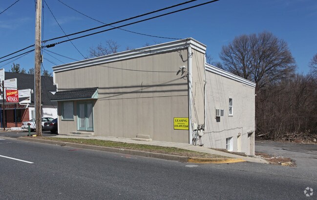
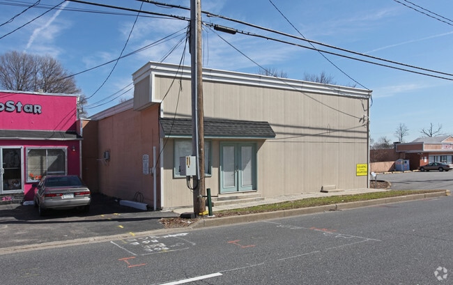
Property Record
1592 Annapolis Rd, Odenton, MD 21113

NEARBY LISTINGS FOR SALE OR LEASE
Property Detail
1592 Annapolis Rd
04-000-01853865
Odenton
Commercialnec
21809 SQ FT ODENTON
X
Anne Arundel
24003C0126E
Maryland
2024
0.50 AC
2025
BWI/Anne Arundel
740305
Baltimore
3,500 SF
Baltimore-Columbia-Towson, MD
DEMOGRAPHICS near 1592 Annapolis Rd
1 mile
3 mile
5 mile
2024 Total Population
11,056
74,388
136,792
2029 Population
11,293
76,432
140,638
Pop Growth 2024-2029
+ 2.14%
+ 2.75%
+ 2.81%
Average Age
34
36
37
2024 Total Households
4,350
27,297
51,114
HH Growth 2024-2029
+ 2.30%
+ 2.83%
+ 2.89%
Median Household Inc
$86,410
$107,680
$109,947
Avg Household Size
2.40
2.60
2.60
2024 Avg HH Vehicles
2.00
2.00
2.00
Median Home Value
$336,332
$385,344
$396,037
Median Year Built
1999
1996
1995
Nearby Places
Map Layers
Map Styles
 Street
 Aerial
Transit
 Traffic
 Biking
Places
Listings with unknown addresses are not visible on the map
- Restaurants
- Banks
- Shops
- Fitness
- Groceries
PUBLIC TRANSPORTATION
COMMUTER RAIL
Odenton (PENN - WASHINGTON - Maryland Area Regional Commuter Trains (The MARC), Penn Line - Maryland Area Regional Commuter Trains (The MARC))
Drive
Walk
Distance
Odenton (PENN - WASHINGTON - Maryland Area Regional Commuter Trains (The MARC), Penn Line - Maryland Area Regional Commuter Trains (The MARC))
5 min
2.5 mi
Savage (Camden Line - Maryland Area Regional Commuter Trains (The MARC))
Drive
Walk
Distance
Savage (Camden Line - Maryland Area Regional Commuter Trains (The MARC))
12 min
7.3 mi
AIRPORT
Baltimore/Washington International Thurgood Marshall
Drive
Walk
Distance
Baltimore/Washington International Thurgood Marshall
16 min
8.8 mi
Ronald Reagan Washington Ntl
Drive
Walk
Distance
Ronald Reagan Washington Ntl
48 min
30.8 mi
Freight Ports
Port of Baltimore
Drive
Walk
Distance
Port of Baltimore
28 min
17.1 mi
Nearby Properties
Address
Land Use
TOTAL SIZE
Lot Size
Zoning
Address
Land Use
TOTAL SIZE
Lot Size
Zoning
8,192 SF
13,053.34 AC
R1
Address
Land Use
TOTAL SIZE
Lot Size
Zoning
472,057 SF
15.16 AC
OCOR
Address
Land Use
TOTAL SIZE
Lot Size
Zoning
155,020 SF
19.86 AC
R22
Address
Land Use
TOTAL SIZE
Lot Size
Zoning
41.07 AC
R15
Address
Land Use
TOTAL SIZE
Lot Size
Zoning
432,928 SF
6.33 AC
O-COR
Address
Land Use
TOTAL SIZE
Lot Size
Zoning
88,272 SF
3.43 AC
OTRA
Address
Land Use
TOTAL SIZE
Lot Size
Zoning
279,318 SF
14.38 AC
R22
Address
Land Use
TOTAL SIZE
Lot Size
Zoning
14.65 AC
R15
Address
Land Use
TOTAL SIZE
Lot Size
Zoning
255,561 SF
15.93 AC
R22
Address
Land Use
TOTAL SIZE
Lot Size
Zoning
499,471 SF
10.10 AC
O-COR
Address
Land Use
TOTAL SIZE
Lot Size
Zoning
311,870 SF
10.03 AC
Address
Land Use
TOTAL SIZE
Lot Size
Zoning
296,453 SF
16.23 AC
R15
Address
Land Use
TOTAL SIZE
Lot Size
Zoning
342,024 SF
30.72 AC
W1B
Address
Land Use
TOTAL SIZE
Lot Size
Zoning
230,204 SF
6.74 AC
O COR
Address
Land Use
TOTAL SIZE
Lot Size
Zoning
126,960 SF
13.72 AC
MXDR
Address
Land Use
TOTAL SIZE
Lot Size
Zoning
130,200 SF
6.60 AC
W1
Address
Land Use
TOTAL SIZE
Lot Size
Zoning
328,950 SF
8.65 AC
W1
Address
Land Use
TOTAL SIZE
Lot Size
Zoning
265,645 SF
12.79 AC
R15
Address
Land Use
TOTAL SIZE
Lot Size
Zoning
448,300 SF
9.80 AC
W-1
Address
Land Use
TOTAL SIZE
Lot Size
Zoning
24.49 AC
C3
Address
Land Use
TOTAL SIZE
Lot Size
Zoning
169,100 SF
22.85 AC
C3
Address
Land Use
TOTAL SIZE
Lot Size
Zoning
473,214 SF
6.78 AC
W1
Address
Land Use
TOTAL SIZE
Lot Size
Zoning
185,440 SF
3.53 AC
W2
Address
Land Use
TOTAL SIZE
Lot Size
Zoning
155,269 SF
13.27 AC
O-EOD
Address
Land Use
TOTAL SIZE
Lot Size
Zoning
342,464 SF
22.95 AC
O-IND
Address
Land Use
TOTAL SIZE
Lot Size
Zoning
89,936 SF
16.40 AC
R15
Address
Land Use
TOTAL SIZE
Lot Size
Zoning
232,480 SF
16.17 AC
R15
Address
Land Use
TOTAL SIZE
Lot Size
Zoning
37,320 SF
18.76 AC
O-COR
Address
Land Use
TOTAL SIZE
Lot Size
Zoning
117,156 SF
3.70 AC
O-NOD
Address
Land Use
TOTAL SIZE
Lot Size
Zoning
10.95 AC
O-EOD
The World's #1 Commercial Real Estate Marketplace
Connect with us
© 2026 CoStar Group
The information above has been obtained from sources believed reliable. While we do not doubt its accuracy we have not verified it and make no guarantee, warranty or representation about it. It is your responsibility to independently confirm its accuracy and completeness. Any projections, opinions, assumptions, or estimates used are for example only and do not represent the current or future performance of the property. The value of this transaction to you depends on tax and other factors which should be evaluated by your tax, financial, and legal advisors. You and your advisors should conduct a careful, independent investigation of the property to determine to your satisfaction the suitability of the property for your needs.