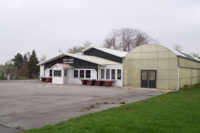
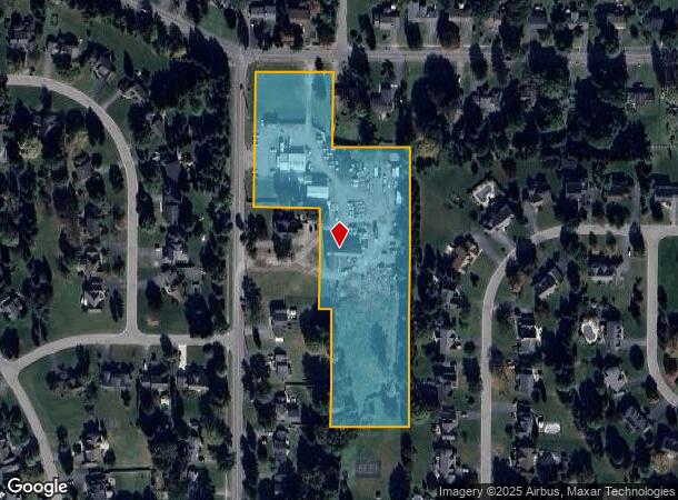
Property Record
1592 Qualtrough Rd, Rochester, NY 14625
NEARBY LISTINGS FOR SALE OR LEASE
Property Detail
1592 Qualtrough Rd
264200-108-160-0001-008-330
L54 T13 R4 HORIZON REAL EST SUB LOT 3
Nurserygreenhouseflorist
Monroe
X
New York
36055C0240G
8.330
2025
5.10 AC
2024
Northeast
011503
Rochester
2,620 SF
Rochester, NY
DEMOGRAPHICS near 1592 Qualtrough Rd
1 Mile
3 Mile
5 Mile
2024 Total Population
6,409
48,203
186,549
2029 Population
6,305
47,630
183,599
Pop Growth 2024-2029
(1.62%)
(1.19%)
(1.58%)
Average Age
43
44
42
2024 Total Households
2,340
21,037
81,815
HH Growth 2024-2029
(1.75%)
(1.24%)
(1.66%)
Median Household Inc
$108,610
$90,140
$69,218
Avg Household Size
2.60
2.20
2.20
2024 Avg HH Vehicles
2.00
2.00
2.00
Median Home Value
$262,172
$206,915
$192,035
Median Year Built
1972
1968
1958
Nearby Places
- Restaurants
- Banks
- Shops
- Fitness
- Groceries
PUBLIC TRANSPORTATION
COMMUTER RAIL
Rochester (Empire Service - VIA Rail, Lake Shore Limited - VIA Rail, Maple Leaf - VIA Rail, Toronto - New York - VIA Rail)
DRIVE
WALK
Distance
Rochester (Empire Service - VIA Rail, Lake Shore Limited - VIA Rail, Maple Leaf - VIA Rail, Toronto - New York - VIA Rail)
15 min
7.2 mi
AIRPORT
Frederick Douglass/Greater Rochester International
DRIVE
WALK
Distance
Frederick Douglass/Greater Rochester International
22 min
11.9 mi
Freight Ports
Albany, NY Port
DRIVE
WALK
Distance
Albany, NY Port
270 min
227.4 mi
Nearby Properties
Address
Land Use
TOTAL SIZE
Lot Size
Zoning
Address
Land Use
TOTAL SIZE
Lot Size
Zoning
640 SF
84.10 AC
RA-2
Address
Land Use
TOTAL SIZE
Lot Size
Zoning
198,655 SF
31.05 AC
02 - SINGL
Address
Land Use
TOTAL SIZE
Lot Size
Zoning
364,800 SF
28.40 AC
R-1-15
Address
Land Use
TOTAL SIZE
Lot Size
Zoning
278,538 SF
53.90 AC
09200
Address
Land Use
TOTAL SIZE
Lot Size
Zoning
283,456 SF
40.76 AC
R-1-20
Address
Land Use
TOTAL SIZE
Lot Size
Zoning
35,546 SF
34.12 AC
GB
Address
Land Use
TOTAL SIZE
Lot Size
Zoning
52,716 SF
10.72 AC
LLD
Address
Land Use
TOTAL SIZE
Lot Size
Zoning
8,064 SF
17.42 AC
Address
Land Use
TOTAL SIZE
Lot Size
Zoning
90,684 SF
20.51 AC
LI
Address
Land Use
TOTAL SIZE
Lot Size
Zoning
38,776 SF
10.33 AC
MR
Address
Land Use
TOTAL SIZE
Lot Size
Zoning
198,229 SF
22.75 AC
GB
Address
Land Use
TOTAL SIZE
Lot Size
Zoning
247,668 SF
36.68 AC
GB
Address
Land Use
TOTAL SIZE
Lot Size
Zoning
3,121 SF
16.17 AC
MR
Address
Land Use
TOTAL SIZE
Lot Size
Zoning
31,378 SF
16.90 AC
03 - MULTI
Address
Land Use
TOTAL SIZE
Lot Size
Zoning
52,716 SF
7.57 AC
LLD
Address
Land Use
TOTAL SIZE
Lot Size
Zoning
118,000 SF
16.38 AC
GB
Address
Land Use
TOTAL SIZE
Lot Size
Zoning
12,024 SF
17 AC
MR
Address
Land Use
TOTAL SIZE
Lot Size
Zoning
67,158 SF
25.29 AC
R-1-20
Address
Land Use
TOTAL SIZE
Lot Size
Zoning
182,943 SF
15.83 AC
LI
Address
Land Use
TOTAL SIZE
Lot Size
Zoning
18,832 SF
31.20 AC
09170
Address
Land Use
TOTAL SIZE
Lot Size
Zoning
62,776 SF
3.24 AC
LI
Address
Land Use
TOTAL SIZE
Lot Size
Zoning
5,693 SF
17.28 AC
Address
Land Use
TOTAL SIZE
Lot Size
Zoning
104,432 SF
14.82 AC
GB
Address
Land Use
TOTAL SIZE
Lot Size
Zoning
71,551 SF
9.80 AC
R-1-15
Address
Land Use
TOTAL SIZE
Lot Size
Zoning
33.29 AC
MHP
Address
Land Use
TOTAL SIZE
Lot Size
Zoning
54,000 SF
13.87 AC
LI
Address
Land Use
TOTAL SIZE
Lot Size
Zoning
70,015 SF
31.92 AC
R-1-20
Address
Land Use
TOTAL SIZE
Lot Size
Zoning
11,536 SF
12.60 AC
MR
Address
Land Use
TOTAL SIZE
Lot Size
Zoning
2,483 SF
13.68 AC
Address
Land Use
TOTAL SIZE
Lot Size
Zoning
22,252 SF
13.21 AC
30040
The World's #1 Commercial Real Estate Marketplace
Connect with us
© 2025 CoStar Group
The information above has been obtained from sources believed reliable. While we do not doubt its accuracy we have not verified it and make no guarantee, warranty or representation about it. It is your responsibility to independently confirm its accuracy and completeness. Any projections, opinions, assumptions, or estimates used are for example only and do not represent the current or future performance of the property. The value of this transaction to you depends on tax and other factors which should be evaluated by your tax, financial, and legal advisors. You and your advisors should conduct a careful, independent investigation of the property to determine to your satisfaction the suitability of the property for your needs.