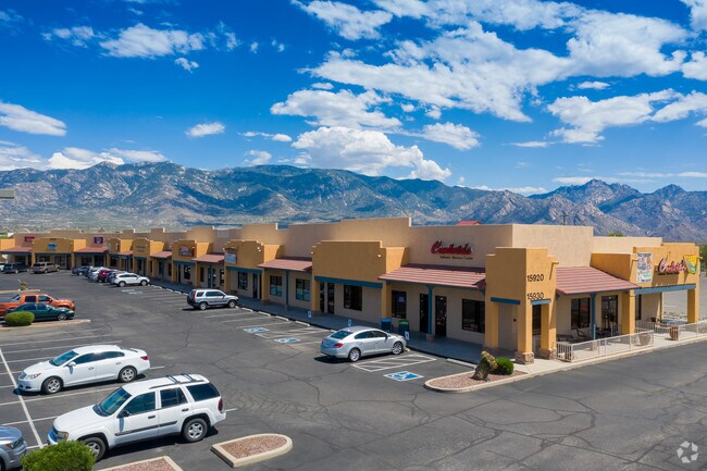
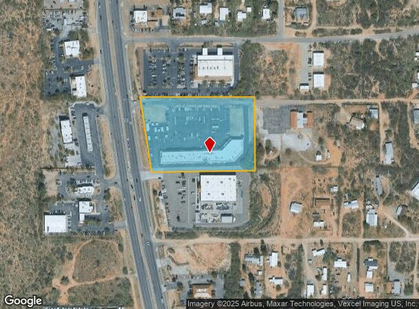
Property Record
15908 N Oracle Rd, Tucson, AZ 85739
NEARBY LISTINGS FOR SALE OR LEASE
-
-
View all Tucson listings for lease on LoopNet.com
Property Detail
15908 N Oracle Rd
222-21-034A
PT S332.1 M/L S2 N2 NW4 NW4 LYG E & ADJ HWY 4.16 AC SEC 9-11-14
Stripcommercialcenter
Pima
X
Arizona
04019C1085L
3
2025
4.16 AC
2025
North/Oro Valley
004715
Tucson
22,734 SF
Tucson, AZ
DEMOGRAPHICS near 15908 N Oracle Rd
1 Mile
3 Mile
5 Mile
2024 Total Population
2,618
16,952
33,244
2029 Population
2,716
18,778
37,180
Pop Growth 2024-2029
+ 3.74%
+ 10.77%
+ 11.84%
Average Age
45
56
57
2024 Total Households
1,053
7,911
15,318
HH Growth 2024-2029
+ 3.80%
+ 10.93%
+ 12.51%
Median Household Inc
$49,075
$74,900
$90,222
Avg Household Size
2.40
2.10
2.10
2024 Avg HH Vehicles
2.00
2.00
2.00
Median Home Value
$229,086
$354,804
$388,439
Median Year Built
1990
1997
1998
Nearby Places
Map Layers
Map Styles
 Street
 Aerial
- Restaurants
- Banks
- Shops
- Fitness
- Groceries
PUBLIC TRANSPORTATION
AIRPORT
Tucson International
DRIVE
WALK
Distance
Tucson International
50 min
29.3 mi
Freight Ports
Port of San Diego
DRIVE
WALK
Distance
Port of San Diego
443 min
408.8 mi
SALE & LEASE HISTORY
LISTING DATE
SALE/LEASE

Dec 18, 2018
For Lease
Aug 22, 2023
For Lease
Aug 06, 2019
For Lease
Nearby Properties
Address
Land Use
TOTAL SIZE
Lot Size
Zoning
Address
Land Use
TOTAL SIZE
Lot Size
Zoning
130,127 SF
175.94 AC
SP
Address
Land Use
TOTAL SIZE
Lot Size
Zoning
175,084 SF
45.61 AC
GR1
Address
Land Use
TOTAL SIZE
Lot Size
Zoning
66,253 SF
7.07 AC
CB1
Address
Land Use
TOTAL SIZE
Lot Size
Zoning
38,076 SF
8.86 AC
GR1
Address
Land Use
TOTAL SIZE
Lot Size
Zoning
21,734 SF
4.68 AC
Address
Land Use
TOTAL SIZE
Lot Size
Zoning
Address
Land Use
TOTAL SIZE
Lot Size
Zoning
576 SF
3.99 AC
GR1
Address
Land Use
TOTAL SIZE
Lot Size
Zoning
15,292 SF
40 AC
RH
Address
Land Use
TOTAL SIZE
Lot Size
Zoning
4,560 SF
3 AC
GR1
Address
Land Use
TOTAL SIZE
Lot Size
Zoning
1,750 SF
1.14 AC
GR1
Address
Land Use
TOTAL SIZE
Lot Size
Zoning
14,506 SF
3.95 AC
PAD
Address
Land Use
TOTAL SIZE
Lot Size
Zoning
24,033 SF
5.06 AC
GR1
Address
Land Use
TOTAL SIZE
Lot Size
Zoning
27,221 SF
3.84 AC
PAD
Address
Land Use
TOTAL SIZE
Lot Size
Zoning
18,964 SF
10.18 AC
RH
Address
Land Use
TOTAL SIZE
Lot Size
Zoning
1,364 SF
17.84 AC
RH
Address
Land Use
TOTAL SIZE
Lot Size
Zoning
16.46 AC
CB1
Address
Land Use
TOTAL SIZE
Lot Size
Zoning
4,994 SF
0.36 AC
CB2
Address
Land Use
TOTAL SIZE
Lot Size
Zoning
2,664 SF
1.10 AC
CB2
Address
Land Use
TOTAL SIZE
Lot Size
Zoning
576 SF
5 AC
RH
Address
Land Use
TOTAL SIZE
Lot Size
Zoning
320 AC
RH
Address
Land Use
TOTAL SIZE
Lot Size
Zoning
19,598 SF
3.25 AC
CB2
Address
Land Use
TOTAL SIZE
Lot Size
Zoning
52,500 SF
3.25 AC
CB2
Address
Land Use
TOTAL SIZE
Lot Size
Zoning
1,152 SF
2.32 AC
GR1
Address
Land Use
TOTAL SIZE
Lot Size
Zoning
2,542 SF
9.09 AC
Address
Land Use
TOTAL SIZE
Lot Size
Zoning
9,100 SF
1.09 AC
Address
Land Use
TOTAL SIZE
Lot Size
Zoning
20,304 SF
1.76 AC
CB2
Address
Land Use
TOTAL SIZE
Lot Size
Zoning
10.30 AC
CB1
Address
Land Use
TOTAL SIZE
Lot Size
Zoning
22,260 SF
1.70 AC
PAD
Address
Land Use
TOTAL SIZE
Lot Size
Zoning
105 SF
3.32 AC
GR1
The World's #1 Commercial Real Estate Marketplace
Connect with us
© 2026 CoStar Group
The information above has been obtained from sources believed reliable. While we do not doubt its accuracy we have not verified it and make no guarantee, warranty or representation about it. It is your responsibility to independently confirm its accuracy and completeness. Any projections, opinions, assumptions, or estimates used are for example only and do not represent the current or future performance of the property. The value of this transaction to you depends on tax and other factors which should be evaluated by your tax, financial, and legal advisors. You and your advisors should conduct a careful, independent investigation of the property to determine to your satisfaction the suitability of the property for your needs.