Property Record
15920 Highway 377 S, Fort Worth, TX 76126
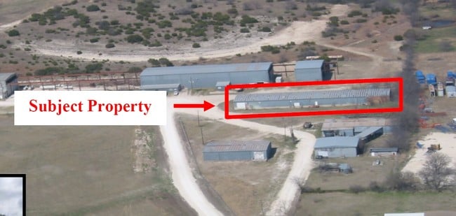

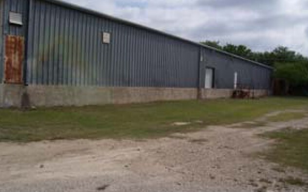
Property Detail
15920 Highway 377 S
20350-005-000-00
ACRES: 10.000 ABST: 350,
Industrialgeneral
PARKER
B and X Area of moderate flood hazard, usually the area between the limits of the 100-year and 500-year floods.
Texas
2024
10 AC
2025
Parker County
140713
Dallas/Ft Worth
43,880 SF
Dallas-Fort Worth-Arlington, TX
NEARBY LISTINGS FOR SALE OR LEASE
-
-
View all Fort Worth listings for sale on LoopNet.com
DEMOGRAPHICS near 15920 Highway 377 S
1 mile
3 mile
5 mile
2024 Total Population
357
5,299
9,903
2029 Population
415
5,994
11,221
Pop Growth 2024-2029
+ 16.25%
+ 13.12%
+ 13.31%
Average Age
41
40
40
2024 Total Households
118
1,799
3,456
HH Growth 2024-2029
+ 15.25%
+ 12.78%
+ 12.82%
Median Household Inc
$149,499
$157,319
$151,084
Avg Household Size
3.00
2.90
2.80
2024 Avg HH Vehicles
3.00
3.00
2.00
Median Home Value
$641,304
$570,799
$583,439
Median Year Built
2005
2010
2010
Nearby Places
Map Layers
Map Styles
 Street
 Aerial
Transit
 Traffic
 Biking
Places
Listings with unknown addresses are not visible on the map
- Restaurants
- Banks
- Shops
- Fitness
- Groceries
Nearby Properties
Address
Land Use
TOTAL SIZE
Lot Size
Zoning
Address
Land Use
TOTAL SIZE
Lot Size
Zoning
Address
Land Use
TOTAL SIZE
Lot Size
Zoning
32,400 SF
10.19 AC
Address
Land Use
TOTAL SIZE
Lot Size
Zoning
53,261 SF
17.04 AC
Address
Land Use
TOTAL SIZE
Lot Size
Zoning
15 SF
13.22 AC
Address
Land Use
TOTAL SIZE
Lot Size
Zoning
Address
Land Use
TOTAL SIZE
Lot Size
Zoning
3.11 AC
Address
Land Use
TOTAL SIZE
Lot Size
Zoning
8,316 SF
3.03 AC
Address
Land Use
TOTAL SIZE
Lot Size
Zoning
9,600 SF
3 AC
Address
Land Use
TOTAL SIZE
Lot Size
Zoning
6,720 SF
9.99 AC
Address
Land Use
TOTAL SIZE
Lot Size
Zoning
15,000 SF
4.32 AC
Address
Land Use
TOTAL SIZE
Lot Size
Zoning
5,294 SF
4.43 AC
Address
Land Use
TOTAL SIZE
Lot Size
Zoning
29,975 SF
2.06 AC
Address
Land Use
TOTAL SIZE
Lot Size
Zoning
11,802 SF
1.70 AC
Address
Land Use
TOTAL SIZE
Lot Size
Zoning
16,448 SF
16.72 AC
Address
Land Use
TOTAL SIZE
Lot Size
Zoning
1,216 SF
15 AC
Address
Land Use
TOTAL SIZE
Lot Size
Zoning
35,800 SF
1.90 AC
Address
Land Use
TOTAL SIZE
Lot Size
Zoning
5.36 AC
Address
Land Use
TOTAL SIZE
Lot Size
Zoning
206.44 AC
Address
Land Use
TOTAL SIZE
Lot Size
Zoning
2.24 AC
Address
Land Use
TOTAL SIZE
Lot Size
Zoning
34,037 SF
2 AC
Address
Land Use
TOTAL SIZE
Lot Size
Zoning
20,258 SF
2.16 AC
Address
Land Use
TOTAL SIZE
Lot Size
Zoning
156.45 AC
Address
Land Use
TOTAL SIZE
Lot Size
Zoning
4,062 SF
1.10 AC
Address
Land Use
TOTAL SIZE
Lot Size
Zoning
3,750 SF
1.50 AC
Address
Land Use
TOTAL SIZE
Lot Size
Zoning
5,040 SF
2.60 AC
Address
Land Use
TOTAL SIZE
Lot Size
Zoning
18,361 SF
2.33 AC
Address
Land Use
TOTAL SIZE
Lot Size
Zoning
Address
Land Use
TOTAL SIZE
Lot Size
Zoning
13,700 SF
3.39 AC
The World's #1 Commercial Real Estate Marketplace
Connect with us
© 2026 CoStar Group
The information above has been obtained from sources believed reliable. While we do not doubt its accuracy we have not verified it and make no guarantee, warranty or representation about it. It is your responsibility to independently confirm its accuracy and completeness. Any projections, opinions, assumptions, or estimates used are for example only and do not represent the current or future performance of the property. The value of this transaction to you depends on tax and other factors which should be evaluated by your tax, financial, and legal advisors. You and your advisors should conduct a careful, independent investigation of the property to determine to your satisfaction the suitability of the property for your needs.