Property Record
15933 Clayton Rd, Ballwin, MO 63011
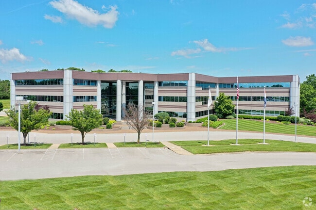

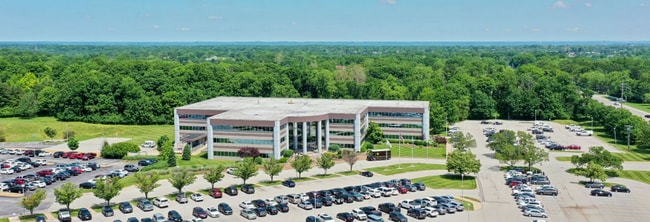
Property Detail
15933 Clayton Rd
22T-53-0186
CLARKSON VALLEY ASSOCIATES 12 13 88 LOT 1
Officebuilding
Saint Louis
87C
Missouri
B and X Area of moderate flood hazard, usually the area between the limits of the 100-year and 500-year floods.
1
2024
12.46 AC
2025
West County
221626
St. Louis
115,050 SF
St. Louis, MO-IL
NEARBY LISTINGS FOR SALE OR LEASE
DEMOGRAPHICS near 15933 Clayton Rd
1 mile
3 mile
5 mile
2024 Total Population
6,668
63,757
136,051
2029 Population
6,548
62,703
134,449
Pop Growth 2024-2029
(1.80%)
(1.65%)
(1.18%)
Average Age
44
43
43
2024 Total Households
2,646
24,486
52,086
HH Growth 2024-2029
(1.78%)
(1.61%)
(1.16%)
Median Household Inc
$138,939
$137,764
$135,068
Avg Household Size
2.50
2.60
2.60
2024 Avg HH Vehicles
2.00
2.00
2.00
Median Home Value
$426,941
$428,204
$428,780
Median Year Built
1977
1982
1982
Nearby Places
Map Layers
Map Styles
 Street
 Aerial
Transit
 Traffic
 Biking
Places
Listings with unknown addresses are not visible on the map
- Restaurants
- Banks
- Shops
- Fitness
- Groceries
PUBLIC TRANSPORTATION
AIRPORT
St Louis Lambert International
Drive
Walk
Distance
St Louis Lambert International
38 min
24.8 mi
SALE & LEASE HISTORY
LISTING DATE
SALE/LEASE

Sep 25, 2016
For Lease
Sep 24, 2016
For Sale
Jan 23, 2019
For Lease
Nearby Properties
Address
Land Use
TOTAL SIZE
Lot Size
Zoning
Address
Land Use
TOTAL SIZE
Lot Size
Zoning
156,253 SF
10.64 AC
87PC
Address
Land Use
TOTAL SIZE
Lot Size
Zoning
70.42 AC
87A
Address
Land Use
TOTAL SIZE
Lot Size
Zoning
51.20 AC
NU
Address
Land Use
TOTAL SIZE
Lot Size
Zoning
344,386 SF
41.26 AC
R2
Address
Land Use
TOTAL SIZE
Lot Size
Zoning
403,166 SF
23.17 AC
R4
Address
Land Use
TOTAL SIZE
Lot Size
Zoning
313,104 SF
14.66 AC
MXD
Address
Land Use
TOTAL SIZE
Lot Size
Zoning
138,056 SF
17.42 AC
NU
Address
Land Use
TOTAL SIZE
Lot Size
Zoning
223,598 SF
13.95 AC
93C-1
Address
Land Use
TOTAL SIZE
Lot Size
Zoning
175,448 SF
6.95 AC
Address
Land Use
TOTAL SIZE
Lot Size
Zoning
111,719 SF
9.51 AC
19C-1
Address
Land Use
TOTAL SIZE
Lot Size
Zoning
153,489 SF
13.01 AC
93C-1
Address
Land Use
TOTAL SIZE
Lot Size
Zoning
247,992 SF
5.72 AC
C
Address
Land Use
TOTAL SIZE
Lot Size
Zoning
2,154 SF
13.19 AC
S
Address
Land Use
TOTAL SIZE
Lot Size
Zoning
7,900 SF
31.95 AC
87A
Address
Land Use
TOTAL SIZE
Lot Size
Zoning
23.18 AC
105NU
Address
Land Use
TOTAL SIZE
Lot Size
Zoning
109,771 SF
11.35 AC
105C8
Address
Land Use
TOTAL SIZE
Lot Size
Zoning
220,288 SF
11.09 AC
93R-4
Address
Land Use
TOTAL SIZE
Lot Size
Zoning
191,316 SF
7.61 AC
R4
Address
Land Use
TOTAL SIZE
Lot Size
Zoning
181,790 SF
16.64 AC
R4
Address
Land Use
TOTAL SIZE
Lot Size
Zoning
16.80 AC
NU
Address
Land Use
TOTAL SIZE
Lot Size
Zoning
164,430 SF
9.85 AC
19C-4
Address
Land Use
TOTAL SIZE
Lot Size
Zoning
128,358 SF
12.01 AC
19C-3
Address
Land Use
TOTAL SIZE
Lot Size
Zoning
247,511 SF
31.03 AC
19M-1
Address
Land Use
TOTAL SIZE
Lot Size
Zoning
74,614 SF
8.05 AC
93C-1
Address
Land Use
TOTAL SIZE
Lot Size
Zoning
83,405 SF
8.25 AC
105C8
Address
Land Use
TOTAL SIZE
Lot Size
Zoning
27.05 AC
R1
Address
Land Use
TOTAL SIZE
Lot Size
Zoning
63,464 SF
6.42 AC
105C8
Address
Land Use
TOTAL SIZE
Lot Size
Zoning
82,686 SF
8.74 AC
C
Address
Land Use
TOTAL SIZE
Lot Size
Zoning
70,267 SF
11.61 AC
19C-3
The World's #1 Commercial Real Estate Marketplace
Connect with us
© 2026 CoStar Group
The information above has been obtained from sources believed reliable. While we do not doubt its accuracy we have not verified it and make no guarantee, warranty or representation about it. It is your responsibility to independently confirm its accuracy and completeness. Any projections, opinions, assumptions, or estimates used are for example only and do not represent the current or future performance of the property. The value of this transaction to you depends on tax and other factors which should be evaluated by your tax, financial, and legal advisors. You and your advisors should conduct a careful, independent investigation of the property to determine to your satisfaction the suitability of the property for your needs.