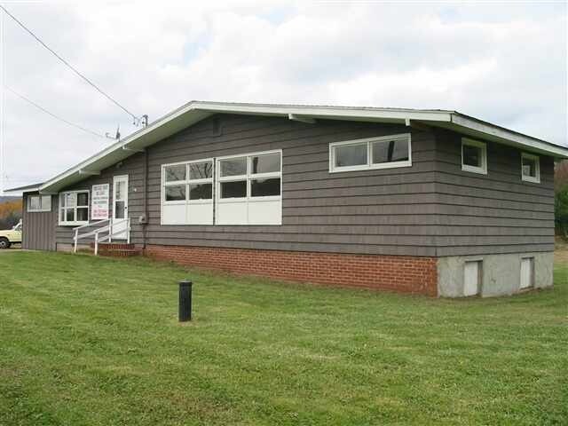
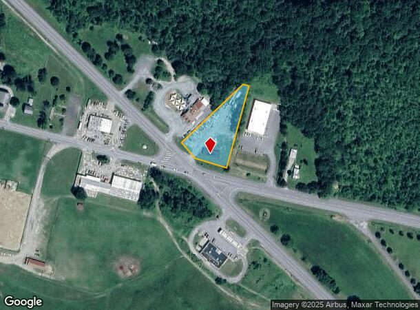
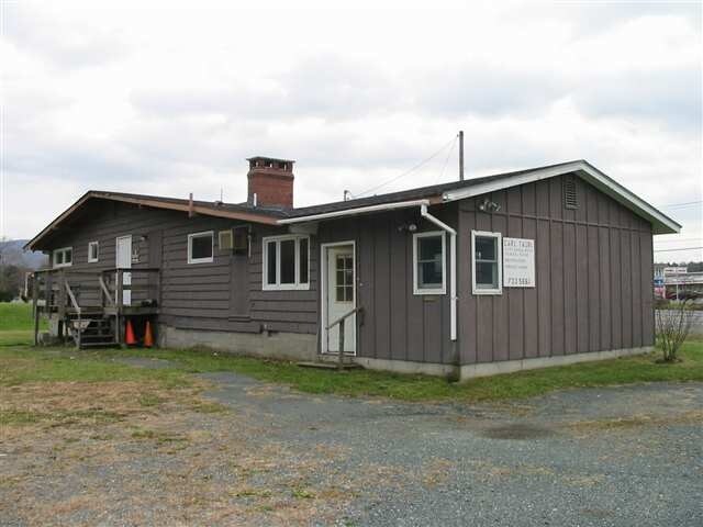
Property Record
15950 State Route 22, Stephentown, NY 12168
NEARBY LISTINGS FOR SALE OR LEASE
-
-
View all Stephentown listings for sale on LoopNet.com
Property Detail
15950 State Route 22
4600-196.3-1-31.2
DEED TO WHITTLE NOT YET FILED
Storesoffices
Rensselaer
ARE
New York
36083C0436D
31.002
2025
0.99 AC
2024
Outer Rensselaer County
052603
Albany/Schenectady/Troy
1,360 SF
Albany-Schenectady-Troy, NY
DEMOGRAPHICS near 15950 State Route 22
1 Mile
3 Mile
5 Mile
2024 Total Population
368
1,490
3,176
2029 Population
360
1,465
3,109
Pop Growth 2024-2029
(2.17%)
(1.68%)
(2.11%)
Average Age
45
45
45
2024 Total Households
163
656
1,366
HH Growth 2024-2029
(1.84%)
(1.83%)
(2.34%)
Median Household Inc
$84,375
$84,534
$81,617
Avg Household Size
2.20
2.20
2.20
2024 Avg HH Vehicles
2.00
2.00
2.00
Median Home Value
$189,473
$202,632
$223,666
Median Year Built
1977
1980
1978
Nearby Places
- Restaurants
- Banks
- Shops
- Fitness
- Groceries
PUBLIC TRANSPORTATION
AIRPORT
Albany International
DRIVE
WALK
Distance
Albany International
51 min
30.5 mi
Freight Ports
Albany, NY Port
DRIVE
WALK
Distance
Albany, NY Port
45 min
26.2 mi
SALE & LEASE HISTORY
LISTING DATE
SALE/LEASE

Sep 26, 2017
For Sale
Sep 23, 2016
For Sale
Nov 03, 2016
For Sale
Jan 30, 2018
For Sale
Nearby Properties
Address
Land Use
TOTAL SIZE
Lot Size
Zoning
Address
Land Use
TOTAL SIZE
Lot Size
Zoning
3.95 AC
RR
Address
Land Use
TOTAL SIZE
Lot Size
Zoning
7.15 AC
RR
Address
Land Use
TOTAL SIZE
Lot Size
Zoning
10.33 AC
RR
Address
Land Use
TOTAL SIZE
Lot Size
Zoning
6,000 SF
4.79 AC
RR
Address
Land Use
TOTAL SIZE
Lot Size
Zoning
16.50 AC
1
Address
Land Use
TOTAL SIZE
Lot Size
Zoning
2,112 SF
42.55 AC
1
Address
Land Use
TOTAL SIZE
Lot Size
Zoning
9,100 SF
1.69 AC
RR
Address
Land Use
TOTAL SIZE
Lot Size
Zoning
2,800 SF
0.49 AC
1
Address
Land Use
TOTAL SIZE
Lot Size
Zoning
24.90 AC
1
Address
Land Use
TOTAL SIZE
Lot Size
Zoning
26,464 SF
4.41 AC
RR
Address
Land Use
TOTAL SIZE
Lot Size
Zoning
2,246 SF
90 AC
1
Address
Land Use
TOTAL SIZE
Lot Size
Zoning
2,047 SF
77.89 AC
RR
Address
Land Use
TOTAL SIZE
Lot Size
Zoning
6,720 SF
11.76 AC
RR
Address
Land Use
TOTAL SIZE
Lot Size
Zoning
2,469 SF
38.40 AC
RR
Address
Land Use
TOTAL SIZE
Lot Size
Zoning
17,992 SF
1.38 AC
RR
Address
Land Use
TOTAL SIZE
Lot Size
Zoning
5,622 SF
0.68 AC
RR
Address
Land Use
TOTAL SIZE
Lot Size
Zoning
1,512 SF
8.63 AC
RR
Address
Land Use
TOTAL SIZE
Lot Size
Zoning
3,128 SF
304.88 AC
RR
Address
Land Use
TOTAL SIZE
Lot Size
Zoning
6,458 SF
1.50 AC
RR
Address
Land Use
TOTAL SIZE
Lot Size
Zoning
941 SF
0.24 AC
1
Address
Land Use
TOTAL SIZE
Lot Size
Zoning
9,006 SF
3.23 AC
RR
Address
Land Use
TOTAL SIZE
Lot Size
Zoning
5,320 SF
0.82 AC
RR
Address
Land Use
TOTAL SIZE
Lot Size
Zoning
1,692 SF
114.60 AC
RR
Address
Land Use
TOTAL SIZE
Lot Size
Zoning
113.44 AC
RR
Address
Land Use
TOTAL SIZE
Lot Size
Zoning
1,800 SF
8.73 AC
RR
Address
Land Use
TOTAL SIZE
Lot Size
Zoning
12,930 SF
2.35 AC
RR
Address
Land Use
TOTAL SIZE
Lot Size
Zoning
6,090 SF
1.44 AC
RR
Address
Land Use
TOTAL SIZE
Lot Size
Zoning
5,000 SF
1.13 AC
RR
Address
Land Use
TOTAL SIZE
Lot Size
Zoning
1,728 SF
5.78 AC
RR
Address
Land Use
TOTAL SIZE
Lot Size
Zoning
1,386 SF
7 AC
RR
The World's #1 Commercial Real Estate Marketplace
Connect with us
© 2025 CoStar Group
The information above has been obtained from sources believed reliable. While we do not doubt its accuracy we have not verified it and make no guarantee, warranty or representation about it. It is your responsibility to independently confirm its accuracy and completeness. Any projections, opinions, assumptions, or estimates used are for example only and do not represent the current or future performance of the property. The value of this transaction to you depends on tax and other factors which should be evaluated by your tax, financial, and legal advisors. You and your advisors should conduct a careful, independent investigation of the property to determine to your satisfaction the suitability of the property for your needs.