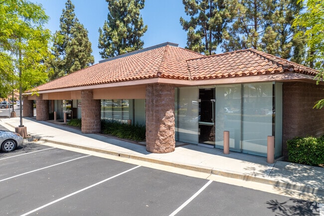
Property Record
1596 N Moorpark Rd, Thousand Oaks, CA 91360


Current Lease Availabilities
NEARBY LISTINGS FOR SALE OR LEASE
Property Detail
1596 N Moorpark Rd
677-0-300-175
9-59, Parcel Map
Financialbuilding
REF: 31 PM 25
X
Ventura
06111C0978E
California
2024
0.70 AC
2025
Thousand Oaks/SE County
006800
Los Angeles
4,201 SF
Oxnard-Thousand Oaks-Ventura, CA
DEMOGRAPHICS near 1596 N Moorpark Rd
1 Mile
3 Mile
5 Mile
2024 Total Population
11,711
80,671
141,275
2029 Population
11,498
79,693
139,317
Pop Growth 2024-2029
(1.82%)
(1.21%)
(1.39%)
Average Age
43
43
44
2024 Total Households
4,090
29,284
51,885
HH Growth 2024-2029
(1.83%)
(1.26%)
(1.46%)
Median Household Inc
$100,845
$110,556
$122,581
Avg Household Size
2.70
2.60
2.60
2024 Avg HH Vehicles
2.00
2.00
2.00
Median Home Value
$764,182
$787,463
$840,883
Median Year Built
1966
1976
1978
Nearby Places
Map Layers
Map Styles
 Street
 Aerial
- Restaurants
- Banks
- Shops
- Fitness
- Groceries
PUBLIC TRANSPORTATION
COMMUTER RAIL
Moorpark (Ventura County Line - Southern California Regional Rail Authority (Metrolink))
DRIVE
WALK
Distance
Moorpark (Ventura County Line - Southern California Regional Rail Authority (Metrolink))
12 min
8.7 mi
AIRPORT
Bob Hope
DRIVE
WALK
Distance
Bob Hope
46 min
35.9 mi
Freight Ports
The Port of Hueneme
DRIVE
WALK
Distance
The Port of Hueneme
35 min
23.7 mi
Nearby Properties
Address
Land Use
TOTAL SIZE
Lot Size
Zoning
Address
Land Use
TOTAL SIZE
Lot Size
Zoning
13.12 AC
PL
Address
Land Use
TOTAL SIZE
Lot Size
Zoning
4,950 SF
50.22 AC
Address
Land Use
TOTAL SIZE
Lot Size
Zoning
5.25 AC
Address
Land Use
TOTAL SIZE
Lot Size
Zoning
239,224 SF
11.65 AC
Address
Land Use
TOTAL SIZE
Lot Size
Zoning
Address
Land Use
TOTAL SIZE
Lot Size
Zoning
384,742 SF
19.93 AC
RPD2
Address
Land Use
TOTAL SIZE
Lot Size
Zoning
199,586 SF
8.95 AC
RPD25
Address
Land Use
TOTAL SIZE
Lot Size
Zoning
15,596 SF
3.17 AC
C2
Address
Land Use
TOTAL SIZE
Lot Size
Zoning
182,756 SF
8.88 AC
RPD1
Address
Land Use
TOTAL SIZE
Lot Size
Zoning
162,078 SF
9.05 AC
R3
Address
Land Use
TOTAL SIZE
Lot Size
Zoning
10.32 AC
PL
Address
Land Use
TOTAL SIZE
Lot Size
Zoning
27.54 AC
PL
Address
Land Use
TOTAL SIZE
Lot Size
Zoning
135.43 AC
Address
Land Use
TOTAL SIZE
Lot Size
Zoning
1.94 AC
Address
Land Use
TOTAL SIZE
Lot Size
Zoning
6.93 AC
PL
Address
Land Use
TOTAL SIZE
Lot Size
Zoning
177,503 SF
5.36 AC
Address
Land Use
TOTAL SIZE
Lot Size
Zoning
26,654 SF
17.84 AC
C3
Address
Land Use
TOTAL SIZE
Lot Size
Zoning
127,196 SF
10.18 AC
MULT
Address
Land Use
TOTAL SIZE
Lot Size
Zoning
206,886 SF
12.11 AC
Address
Land Use
TOTAL SIZE
Lot Size
Zoning
90,194 SF
4.12 AC
Address
Land Use
TOTAL SIZE
Lot Size
Zoning
5.08 AC
PL
Address
Land Use
TOTAL SIZE
Lot Size
Zoning
74,757 SF
9.01 AC
Address
Land Use
TOTAL SIZE
Lot Size
Zoning
Address
Land Use
TOTAL SIZE
Lot Size
Zoning
68,015 SF
1.22 AC
Address
Land Use
TOTAL SIZE
Lot Size
Zoning
89,664 SF
5.03 AC
R-3
Address
Land Use
TOTAL SIZE
Lot Size
Zoning
123,248 SF
8.70 AC
RPD2
Address
Land Use
TOTAL SIZE
Lot Size
Zoning
73,565 SF
5.27 AC
MULT
Address
Land Use
TOTAL SIZE
Lot Size
Zoning
21,878 SF
8.22 AC
C4
Address
Land Use
TOTAL SIZE
Lot Size
Zoning
2.13 AC
M1
Address
Land Use
TOTAL SIZE
Lot Size
Zoning
The World's #1 Commercial Real Estate Marketplace
Connect with us
© 2026 CoStar Group
The information above has been obtained from sources believed reliable. While we do not doubt its accuracy we have not verified it and make no guarantee, warranty or representation about it. It is your responsibility to independently confirm its accuracy and completeness. Any projections, opinions, assumptions, or estimates used are for example only and do not represent the current or future performance of the property. The value of this transaction to you depends on tax and other factors which should be evaluated by your tax, financial, and legal advisors. You and your advisors should conduct a careful, independent investigation of the property to determine to your satisfaction the suitability of the property for your needs.