Property Record
15960 S Marks Rd, Columbia Station, OH 44028
NEARBY LISTINGS FOR SALE OR LEASE
-
-
View all Columbia Station listings for sale on LoopNet.com
Property Detail
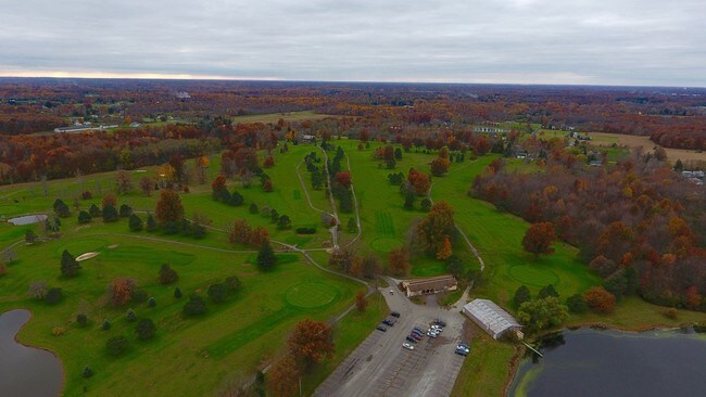
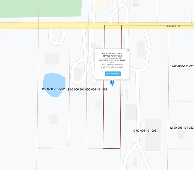
15960 S Marks Rd
Cleveland-Elyria, OH
Acr Corr
12-00-007-000-005
20030909205
Golfcourse
Lorain
X
Ohio
39035C0267E
15
2024
110 AC
2024
Lorain County
090100
Cleveland
DEMOGRAPHICS near 15960 S Marks Rd
1 Mile
3 Mile
5 Mile
2024 Total Population
1,026
27,461
95,947
2029 Population
1,087
27,196
94,770
Pop Growth 2024-2029
+ 5.95%
(0.97%)
(1.23%)
Average Age
44
45
43
2024 Total Households
389
10,913
38,110
HH Growth 2024-2029
+ 5.91%
(1.20%)
(1.50%)
Median Household Inc
$113,297
$104,977
$94,732
Avg Household Size
2.60
2.40
2.40
2024 Avg HH Vehicles
2.00
2.00
2.00
Median Home Value
$373,124
$302,437
$278,194
Median Year Built
1974
1980
1977
Nearby Places
Map Layers
Map Styles
 Street
 Aerial
- Restaurants
- Banks
- Shops
- Fitness
- Groceries
PUBLIC TRANSPORTATION
AIRPORT
Cleveland-Hopkins International
DRIVE
WALK
Distance
Cleveland-Hopkins International
24 min
11.7 mi
Freight Ports
Port of Toledo
DRIVE
WALK
Distance
Port of Toledo
121 min
100.4 mi
SALE & LEASE HISTORY
LISTING DATE
SALE/LEASE

Sep 09, 2020
For Sale
Oct 18, 2019
For Sale
Nearby Properties
Address
Land Use
TOTAL SIZE
Lot Size
Zoning
Address
Land Use
TOTAL SIZE
Lot Size
Zoning
80,578 SF
46.73 AC
Address
Land Use
TOTAL SIZE
Lot Size
Zoning
63,904 SF
19.62 AC
Address
Land Use
TOTAL SIZE
Lot Size
Zoning
19,870 SF
16.12 AC
Address
Land Use
TOTAL SIZE
Lot Size
Zoning
97,302 SF
7.89 AC
D-5
Address
Land Use
TOTAL SIZE
Lot Size
Zoning
104,215 SF
5.90 AC
Address
Land Use
TOTAL SIZE
Lot Size
Zoning
11,000 SF
28.37 AC
Address
Land Use
TOTAL SIZE
Lot Size
Zoning
523,378 SF
41.94 AC
Address
Land Use
TOTAL SIZE
Lot Size
Zoning
155.53 AC
Address
Land Use
TOTAL SIZE
Lot Size
Zoning
8,480 SF
32 AC
Address
Land Use
TOTAL SIZE
Lot Size
Zoning
9,764 SF
56.20 AC
Address
Land Use
TOTAL SIZE
Lot Size
Zoning
3,600 SF
124.90 AC
Address
Land Use
TOTAL SIZE
Lot Size
Zoning
11,164 SF
4.36 AC
Address
Land Use
TOTAL SIZE
Lot Size
Zoning
64,180 SF
13.03 AC
Address
Land Use
TOTAL SIZE
Lot Size
Zoning
8,827 SF
45.42 AC
Address
Land Use
TOTAL SIZE
Lot Size
Zoning
19,000 SF
4.59 AC
Address
Land Use
TOTAL SIZE
Lot Size
Zoning
4,862 SF
3.24 AC
Address
Land Use
TOTAL SIZE
Lot Size
Zoning
15,115 SF
4.85 AC
Address
Land Use
TOTAL SIZE
Lot Size
Zoning
131.87 AC
Address
Land Use
TOTAL SIZE
Lot Size
Zoning
22,902 SF
8.98 AC
Address
Land Use
TOTAL SIZE
Lot Size
Zoning
59,376 SF
26.47 AC
Address
Land Use
TOTAL SIZE
Lot Size
Zoning
25,850 SF
16.10 AC
Address
Land Use
TOTAL SIZE
Lot Size
Zoning
3,934 SF
8.12 AC
Address
Land Use
TOTAL SIZE
Lot Size
Zoning
23,957 SF
3.99 AC
Address
Land Use
TOTAL SIZE
Lot Size
Zoning
7,877 SF
30 AC
Address
Land Use
TOTAL SIZE
Lot Size
Zoning
7,300 SF
6.35 AC
Address
Land Use
TOTAL SIZE
Lot Size
Zoning
162.01 AC
Address
Land Use
TOTAL SIZE
Lot Size
Zoning
28,728 SF
23.60 AC
Address
Land Use
TOTAL SIZE
Lot Size
Zoning
5,346 SF
1.85 AC
Address
Land Use
TOTAL SIZE
Lot Size
Zoning
13,700 SF
49.25 AC
The World's #1 Commercial Real Estate Marketplace
Connect with us
© 2025 CoStar Group
The information above has been obtained from sources believed reliable. While we do not doubt its accuracy we have not verified it and make no guarantee, warranty or representation about it. It is your responsibility to independently confirm its accuracy and completeness. Any projections, opinions, assumptions, or estimates used are for example only and do not represent the current or future performance of the property. The value of this transaction to you depends on tax and other factors which should be evaluated by your tax, financial, and legal advisors. You and your advisors should conduct a careful, independent investigation of the property to determine to your satisfaction the suitability of the property for your needs.