Property Record
924 Davis St, Evanston, IL 60201
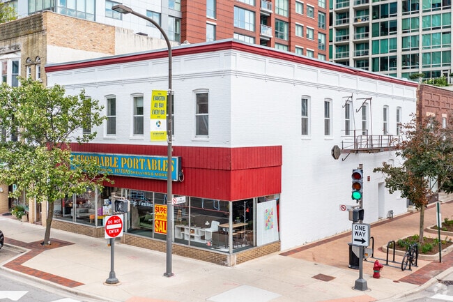


Property Detail
924 Davis St
11-18-310-001-0000
(VILLAGE) OF (EVANSTON) IN SECS 13-41-13 & 7,18 & 19- 41-14 SEC 18-41-14
Storebuilding
COOK
B and X Area of moderate flood hazard, usually the area between the limits of the 100-year and 500-year floods.
Illinois
2023
0.69 AC
2025
Near North
809500
Chicago
5,824 SF
Chicago-Naperville-Elgin, IL-IN
NEARBY LISTINGS FOR SALE OR LEASE
DEMOGRAPHICS near 924 Davis St
1 mile
3 mile
5 mile
2025 Total Population
38,694
187,955
442,807
2030 Population
39,178
189,299
445,805
Pop Growth 2025-2030
+ 1.25%
+ 0.72%
+ 0.68%
Average Age
37
41
41
2025 Total Households
15,492
73,878
175,790
HH Growth 2025-2030
+ 1.34%
+ 0.55%
+ 0.49%
Median Household Inc
$77,294
$88,646
$82,558
Avg Household Size
2.00
2.30
2.30
2025 Avg HH Vehicles
1.00
1.00
1.00
Median Home Value
$470,501
$436,967
$413,921
Median Year Built
1957
1951
1952
Nearby Places
Map Layers
Map Styles
 Street
 Aerial
Layers
 Traffic
 Biking
Places
Listings with unknown addresses are not visible on the map
- Restaurants
- Banks
- Shops
- Fitness
- Groceries
PUBLIC TRANSPORTATION
TRANSIT/SUBWAY
Evanston Davis Street Station (Union Pacific North Line - Northeast Illinois Regional Commuter Railroad (Metra))
Drive
Walk
Distance
Evanston Davis Street Station (Union Pacific North Line - Northeast Illinois Regional Commuter Railroad (Metra))
0 min
2 min
0.1 mi
Davis Station (Purple Line - Chicago Transit Authority "L" Trains (The "L"))
Drive
Walk
Distance
Davis Station (Purple Line - Chicago Transit Authority "L" Trains (The "L"))
1 min
2 min
0.1 mi
Dempster Station (Purple Line - Chicago Transit Authority "L" Trains (The "L"))
Drive
Walk
Distance
Dempster Station (Purple Line - Chicago Transit Authority "L" Trains (The "L"))
1 min
9 min
0.5 mi
Foster Station (Purple Line - Chicago Transit Authority "L" Trains (The "L"))
Drive
Walk
Distance
Foster Station (Purple Line - Chicago Transit Authority "L" Trains (The "L"))
2 min
12 min
0.6 mi
Noyes Station (Purple Line - Chicago Transit Authority "L" Trains (The "L"))
Drive
Walk
Distance
Noyes Station (Purple Line - Chicago Transit Authority "L" Trains (The "L"))
2 min
17 min
0.9 mi
COMMUTER RAIL
Evanston Davis Street Station (Union Pacific North Line - Northeast Illinois Regional Commuter Railroad (Metra))
Drive
Walk
Distance
Evanston Davis Street Station (Union Pacific North Line - Northeast Illinois Regional Commuter Railroad (Metra))
0 min
2 min
0.1 mi
Evanston Main Street Station (Union Pacific North Line - Northeast Illinois Regional Commuter Railroad (Metra))
Drive
Walk
Distance
Evanston Main Street Station (Union Pacific North Line - Northeast Illinois Regional Commuter Railroad (Metra))
4 min
1.4 mi
AIRPORT
Chicago O'Hare International
Drive
Walk
Distance
Chicago O'Hare International
51 min
20.5 mi
Chicago Midway International
Drive
Walk
Distance
Chicago Midway International
43 min
22.6 mi
SALE & LEASE HISTORY
LISTING DATE
SALE/LEASE

Sep 24, 2016
For Lease
Feb 12, 2021
For Lease
Nearby Properties
Address
Land Use
TOTAL SIZE
Lot Size
Zoning
Address
Land Use
TOTAL SIZE
Lot Size
Zoning
180,397 SF
0.78 AC
Address
Land Use
TOTAL SIZE
Lot Size
Zoning
0.63 AC
Address
Land Use
TOTAL SIZE
Lot Size
Zoning
892,012 SF
37.29 AC
Address
Land Use
TOTAL SIZE
Lot Size
Zoning
341,698 SF
0.64 AC
Address
Land Use
TOTAL SIZE
Lot Size
Zoning
305,592 SF
27.35 AC
Address
Land Use
TOTAL SIZE
Lot Size
Zoning
4,748 SF
0.40 AC
Address
Land Use
TOTAL SIZE
Lot Size
Zoning
303,960 SF
0.98 AC
Address
Land Use
TOTAL SIZE
Lot Size
Zoning
0.84 AC
Address
Land Use
TOTAL SIZE
Lot Size
Zoning
82,139 SF
4.88 AC
Address
Land Use
TOTAL SIZE
Lot Size
Zoning
251,409 SF
16.33 AC
Address
Land Use
TOTAL SIZE
Lot Size
Zoning
176,115 SF
1.04 AC
Address
Land Use
TOTAL SIZE
Lot Size
Zoning
218,982 SF
1.97 AC
Address
Land Use
TOTAL SIZE
Lot Size
Zoning
243,781 SF
0.84 AC
Address
Land Use
TOTAL SIZE
Lot Size
Zoning
110,528 SF
3.05 AC
Address
Land Use
TOTAL SIZE
Lot Size
Zoning
0.84 AC
Address
Land Use
TOTAL SIZE
Lot Size
Zoning
Address
Land Use
TOTAL SIZE
Lot Size
Zoning
163,981 SF
4 AC
Address
Land Use
TOTAL SIZE
Lot Size
Zoning
145,548 SF
0.80 AC
Address
Land Use
TOTAL SIZE
Lot Size
Zoning
8,550 SF
0.25 AC
Address
Land Use
TOTAL SIZE
Lot Size
Zoning
1.67 AC
Address
Land Use
TOTAL SIZE
Lot Size
Zoning
2.46 AC
Address
Land Use
TOTAL SIZE
Lot Size
Zoning
208,785 SF
0.61 AC
Address
Land Use
TOTAL SIZE
Lot Size
Zoning
5.65 AC
Address
Land Use
TOTAL SIZE
Lot Size
Zoning
190,350 SF
1.03 AC
Address
Land Use
TOTAL SIZE
Lot Size
Zoning
0.30 AC
Address
Land Use
TOTAL SIZE
Lot Size
Zoning
0.38 AC
Address
Land Use
TOTAL SIZE
Lot Size
Zoning
223,366 SF
0.65 AC
Address
Land Use
TOTAL SIZE
Lot Size
Zoning
72,503 SF
5.60 AC
Address
Land Use
TOTAL SIZE
Lot Size
Zoning
117,229 SF
Address
Land Use
TOTAL SIZE
Lot Size
Zoning
1.62 AC
The World's #1 Commercial Real Estate Marketplace
Connect with us
© 2026 CoStar Group
The information above has been obtained from sources believed reliable. While we do not doubt its accuracy we have not verified it and make no guarantee, warranty or representation about it. It is your responsibility to independently confirm its accuracy and completeness. Any projections, opinions, assumptions, or estimates used are for example only and do not represent the current or future performance of the property. The value of this transaction to you depends on tax and other factors which should be evaluated by your tax, financial, and legal advisors. You and your advisors should conduct a careful, independent investigation of the property to determine to your satisfaction the suitability of the property for your needs.