Property Record
1220 Henley Ln, Baker, FL 32531
This Property Is For Sale
NEARBY LISTINGS FOR SALE OR LEASE
-
-
View all Baker listings for sale on LoopNet.com
Property Detail
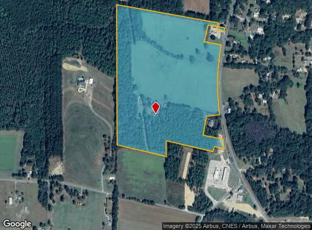
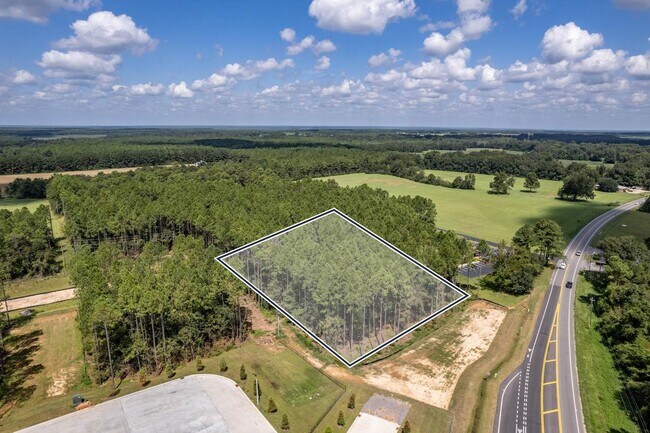
1220 Henley Ln
06-3N-24-0000-0021-0000
COM NW COR GOV LOT 5 S 79 DEG E 917.25FT TO NW COR GOV LOT 6 & POB CONT S 79 DEG E 1223.74FT S 14 DEG W 224.96FT S 79 DEG E 229.16FT TO W R/W HWY 4 THC SLY ALG R/W 905.36FT S 84 DEG W 166.56FT S 14 DEG W 251.98FT S 75 DEG E 270.22FT TO W R/W HWY 4 S
Agriculturalland
Okaloosa
X
Florida
12091C0145J
5,6
2025
52.69 AC
2025
Fort Walton Beach
020102
Other Market Areas
3,004 SF
Crestview-Fort Walton Beach-Destin, FL
DEMOGRAPHICS near 1220 Henley Ln
1 Mile
3 Mile
5 Mile
2024 Total Population
824
3,462
7,639
2029 Population
870
3,648
8,084
Pop Growth 2024-2029
+ 5.58%
+ 5.37%
+ 5.83%
Average Age
40
40
39
2024 Total Households
306
1,287
2,809
HH Growth 2024-2029
+ 5.56%
+ 5.36%
+ 5.80%
Median Household Inc
$64,113
$69,341
$74,485
Avg Household Size
2.60
2.60
2.60
2024 Avg HH Vehicles
2.00
2.00
2.00
Median Home Value
$278,124
$272,313
$265,485
Median Year Built
1997
1998
2000
Nearby Places
Map Layers
Map Styles
 Street
 Aerial
- Restaurants
- Banks
- Shops
- Fitness
- Groceries
PUBLIC TRANSPORTATION
AIRPORT
Eglin AFB/Destin-Ft Walton Beach
DRIVE
WALK
Distance
Eglin AFB/Destin-Ft Walton Beach
57 min
32.5 mi
Freight Ports
Port of Panama City
DRIVE
WALK
Distance
Port of Panama City
125 min
94.8 mi
Nearby Properties
Address
Land Use
TOTAL SIZE
Lot Size
Zoning
Address
Land Use
TOTAL SIZE
Lot Size
Zoning
214,151 SF
4.14 AC
Address
Land Use
TOTAL SIZE
Lot Size
Zoning
53,463 SF
9.90 AC
Address
Land Use
TOTAL SIZE
Lot Size
Zoning
33,162 SF
4.48 AC
Address
Land Use
TOTAL SIZE
Lot Size
Zoning
36,224 SF
8.26 AC
Address
Land Use
TOTAL SIZE
Lot Size
Zoning
39,937 SF
51.25 AC
Address
Land Use
TOTAL SIZE
Lot Size
Zoning
10,539 SF
1.13 AC
Address
Land Use
TOTAL SIZE
Lot Size
Zoning
9,796 SF
6.11 AC
Address
Land Use
TOTAL SIZE
Lot Size
Zoning
13,398 SF
108.17 AC
Address
Land Use
TOTAL SIZE
Lot Size
Zoning
6,831 SF
152.02 AC
Address
Land Use
TOTAL SIZE
Lot Size
Zoning
13,393 SF
55 AC
Address
Land Use
TOTAL SIZE
Lot Size
Zoning
13,936 SF
2.28 AC
Address
Land Use
TOTAL SIZE
Lot Size
Zoning
7,804 SF
10.63 AC
Address
Land Use
TOTAL SIZE
Lot Size
Zoning
6,231 SF
23 AC
Address
Land Use
TOTAL SIZE
Lot Size
Zoning
9,230 SF
2 AC
Address
Land Use
TOTAL SIZE
Lot Size
Zoning
5,134 SF
10 AC
Address
Land Use
TOTAL SIZE
Lot Size
Zoning
4,334 SF
15.27 AC
Address
Land Use
TOTAL SIZE
Lot Size
Zoning
4,415 SF
14 AC
Address
Land Use
TOTAL SIZE
Lot Size
Zoning
14,027 SF
10.38 AC
Address
Land Use
TOTAL SIZE
Lot Size
Zoning
6,738 SF
48.99 AC
Address
Land Use
TOTAL SIZE
Lot Size
Zoning
22,877 SF
5.12 AC
Address
Land Use
TOTAL SIZE
Lot Size
Zoning
11,320 SF
1.78 AC
Address
Land Use
TOTAL SIZE
Lot Size
Zoning
3,556 SF
10 AC
Address
Land Use
TOTAL SIZE
Lot Size
Zoning
7,022 SF
40.50 AC
Address
Land Use
TOTAL SIZE
Lot Size
Zoning
4,059 SF
10 AC
Address
Land Use
TOTAL SIZE
Lot Size
Zoning
145.53 AC
Address
Land Use
TOTAL SIZE
Lot Size
Zoning
5,808 SF
39.16 AC
Address
Land Use
TOTAL SIZE
Lot Size
Zoning
4,146 SF
12 AC
Address
Land Use
TOTAL SIZE
Lot Size
Zoning
3,846 SF
9.01 AC
Address
Land Use
TOTAL SIZE
Lot Size
Zoning
3,555 SF
20.43 AC
Address
Land Use
TOTAL SIZE
Lot Size
Zoning
7,228 SF
19 AC
The World's #1 Commercial Real Estate Marketplace
Connect with us
© 2026 CoStar Group
The information above has been obtained from sources believed reliable. While we do not doubt its accuracy we have not verified it and make no guarantee, warranty or representation about it. It is your responsibility to independently confirm its accuracy and completeness. Any projections, opinions, assumptions, or estimates used are for example only and do not represent the current or future performance of the property. The value of this transaction to you depends on tax and other factors which should be evaluated by your tax, financial, and legal advisors. You and your advisors should conduct a careful, independent investigation of the property to determine to your satisfaction the suitability of the property for your needs.