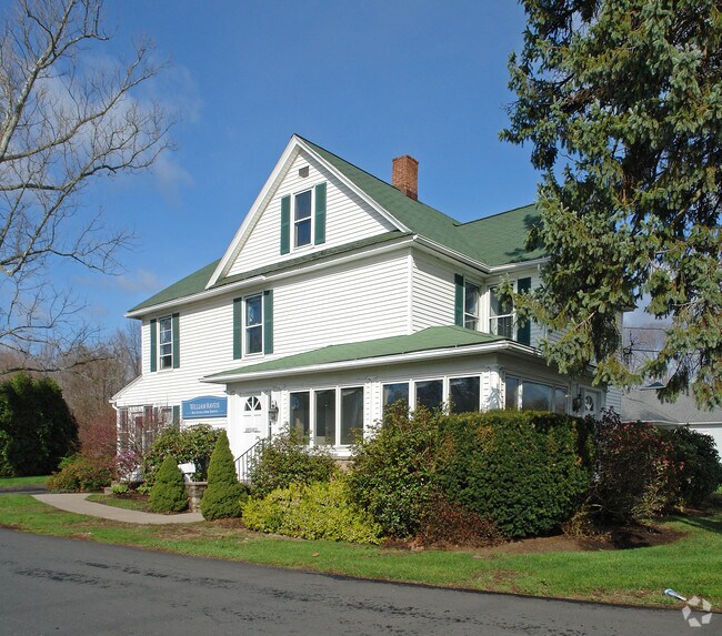
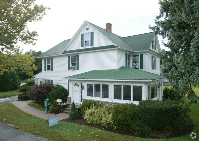
Property Record
15R Hartford Ave, Granby, CT 06035
NEARBY LISTINGS FOR SALE OR LEASE
Property Detail
15R Hartford Ave
GRAN-000053G-000078-000005
Hartford
Commercialbuilding
Connecticut
X
4
09003C0183F
1.36 AC
2025
Northwest Outlying
2025
Hartford
468102
Hartford-West Hartford-East Hartford, CT
16,563 SF
DEMOGRAPHICS near 15R Hartford Ave
1 Mile
3 Mile
5 Mile
2024 Total Population
2,164
10,872
27,965
2029 Population
2,156
10,813
27,810
Pop Growth 2024-2029
(0.37%)
(0.54%)
(0.55%)
Average Age
45
43
43
2024 Total Households
906
4,368
10,998
HH Growth 2024-2029
(0.44%)
(0.60%)
(0.59%)
Median Household Inc
$101,424
$116,774
$118,814
Avg Household Size
2.30
2.40
2.50
2024 Avg HH Vehicles
2.00
2.00
2.00
Median Home Value
$317,799
$332,410
$337,372
Median Year Built
1974
1973
1972
Nearby Places
Map Layers
Map Styles
 Street
 Aerial
- Restaurants
- Banks
- Shops
- Fitness
- Groceries
PUBLIC TRANSPORTATION
AIRPORT
Bradley International
DRIVE
WALK
Distance
Bradley International
22 min
9.6 mi
Freight Ports
Port of New Haven
DRIVE
WALK
Distance
Port of New Haven
79 min
58.3 mi
SALE & LEASE HISTORY
LISTING DATE
SALE/LEASE

May 23, 2018
For Sale
Jun 19, 2018
For Sale
Jun 17, 2019
For Sale
Nearby Properties
Address
Land Use
TOTAL SIZE
Lot Size
Zoning
Address
Land Use
TOTAL SIZE
Lot Size
Zoning
1,517 SF
45.69 AC
CC
Address
Land Use
TOTAL SIZE
Lot Size
Zoning
27.95 AC
CC
Address
Land Use
TOTAL SIZE
Lot Size
Zoning
34.66 AC
T1
Address
Land Use
TOTAL SIZE
Lot Size
Zoning
1,576 SF
9.52 AC
T1
Address
Land Use
TOTAL SIZE
Lot Size
Zoning
37,178 SF
4.40 AC
R-25
Address
Land Use
TOTAL SIZE
Lot Size
Zoning
58,477 SF
14.99 AC
R30
Address
Land Use
TOTAL SIZE
Lot Size
Zoning
13.65 AC
R-40
Address
Land Use
TOTAL SIZE
Lot Size
Zoning
49.92 AC
Address
Land Use
TOTAL SIZE
Lot Size
Zoning
49.92 AC
Address
Land Use
TOTAL SIZE
Lot Size
Zoning
61,692 SF
12 AC
R50
Address
Land Use
TOTAL SIZE
Lot Size
Zoning
13.05 AC
C2
Address
Land Use
TOTAL SIZE
Lot Size
Zoning
5.32 AC
ED
Address
Land Use
TOTAL SIZE
Lot Size
Zoning
14.38 AC
CC
Address
Land Use
TOTAL SIZE
Lot Size
Zoning
52,458 SF
2.15 AC
PAD
Address
Land Use
TOTAL SIZE
Lot Size
Zoning
5.96 AC
CO
Address
Land Use
TOTAL SIZE
Lot Size
Zoning
71,092 SF
6.23 AC
T1
Address
Land Use
TOTAL SIZE
Lot Size
Zoning
54,568 SF
11.74 AC
C2
Address
Land Use
TOTAL SIZE
Lot Size
Zoning
7.40 AC
CE
Address
Land Use
TOTAL SIZE
Lot Size
Zoning
43,094 SF
33.80 AC
R30
Address
Land Use
TOTAL SIZE
Lot Size
Zoning
1,064.60 AC
R2A
Address
Land Use
TOTAL SIZE
Lot Size
Zoning
19,756 SF
2.63 AC
B-2
Address
Land Use
TOTAL SIZE
Lot Size
Zoning
36,119 SF
17.70 AC
VC
Address
Land Use
TOTAL SIZE
Lot Size
Zoning
88.35 AC
I
Address
Land Use
TOTAL SIZE
Lot Size
Zoning
32,748 SF
1.54 AC
I-2
Address
Land Use
TOTAL SIZE
Lot Size
Zoning
12.98 AC
I
Address
Land Use
TOTAL SIZE
Lot Size
Zoning
12.98 AC
Address
Land Use
TOTAL SIZE
Lot Size
Zoning
1,280 SF
91 AC
I-1
Address
Land Use
TOTAL SIZE
Lot Size
Zoning
2.70 AC
CO
Address
Land Use
TOTAL SIZE
Lot Size
Zoning
30,936 SF
15.40 AC
A
Address
Land Use
TOTAL SIZE
Lot Size
Zoning
22.23 AC
R2A
The World's #1 Commercial Real Estate Marketplace
Connect with us
© 2026 CoStar Group
The information above has been obtained from sources believed reliable. While we do not doubt its accuracy we have not verified it and make no guarantee, warranty or representation about it. It is your responsibility to independently confirm its accuracy and completeness. Any projections, opinions, assumptions, or estimates used are for example only and do not represent the current or future performance of the property. The value of this transaction to you depends on tax and other factors which should be evaluated by your tax, financial, and legal advisors. You and your advisors should conduct a careful, independent investigation of the property to determine to your satisfaction the suitability of the property for your needs.