Property Record
15Th Ave S, Myrtle Beach, SC 29575
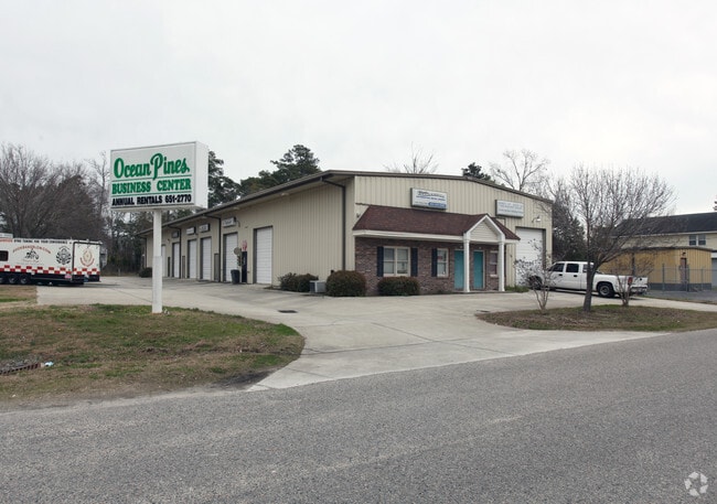

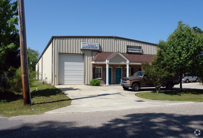
Property Detail
15Th Ave S
Myrtle Beach-Conway-North Myrtle Beach, SC
OCEAN PINE; LT 7 6 PT 5 BL 24
46212010016
HORRY
Officebuilding
South Carolina
B and X Area of moderate flood hazard, usually the area between the limits of the 100-year and 500-year floods.
6-7
2025
0.68 AC
2025
Outlying Horry County
051404
Myrtle Beach/Conway
8,250 SF
NEARBY LISTINGS FOR SALE OR LEASE
-
-
View all Myrtle Beach listings for sale on LoopNet.com
DEMOGRAPHICS near 15Th Ave S
1 mile
3 mile
5 mile
2025 Total Population
10,047
45,283
87,123
2030 Population
11,975
52,673
99,663
Pop Growth 2025-2030
+ 19.19%
+ 16.32%
+ 14.39%
Average Age
54
52
51
2025 Total Households
5,044
21,628
40,137
HH Growth 2025-2030
+ 19.19%
+ 16.34%
+ 14.43%
Median Household Inc
$74,749
$72,993
$75,012
Avg Household Size
1.90
2.00
2.10
2025 Avg HH Vehicles
2.00
2.00
2.00
Median Home Value
$320,040
$323,905
$333,171
Median Year Built
1990
1993
1999
Nearby Places
Map Layers
Map Styles
 Street
 Aerial
Layers
 Traffic
 Biking
Places
Listings with unknown addresses are not visible on the map
- Restaurants
- Banks
- Shops
- Fitness
- Groceries
PUBLIC TRANSPORTATION
AIRPORT
Myrtle Beach International
Drive
Walk
Distance
Myrtle Beach International
16 min
8.0 mi
Nearby Properties
Address
Land Use
TOTAL SIZE
Lot Size
Zoning
Address
Land Use
TOTAL SIZE
Lot Size
Zoning
17,640 SF
240.91 AC
Address
Land Use
TOTAL SIZE
Lot Size
Zoning
9,772 SF
130.49 AC
Address
Land Use
TOTAL SIZE
Lot Size
Zoning
28,959 SF
31.56 AC
Address
Land Use
TOTAL SIZE
Lot Size
Zoning
7,144 SF
188.69 AC
Address
Land Use
TOTAL SIZE
Lot Size
Zoning
151,727 SF
20.92 AC
Address
Land Use
TOTAL SIZE
Lot Size
Zoning
3,696 SF
55.20 AC
Address
Land Use
TOTAL SIZE
Lot Size
Zoning
636.81 AC
Address
Land Use
TOTAL SIZE
Lot Size
Zoning
39,275 SF
14.87 AC
Address
Land Use
TOTAL SIZE
Lot Size
Zoning
2,510 SF
43.14 AC
Address
Land Use
TOTAL SIZE
Lot Size
Zoning
25,722 SF
13.73 AC
Address
Land Use
TOTAL SIZE
Lot Size
Zoning
8,640 SF
5.47 AC
Address
Land Use
TOTAL SIZE
Lot Size
Zoning
4,800 SF
75.54 AC
Address
Land Use
TOTAL SIZE
Lot Size
Zoning
57,216 SF
2.36 AC
Address
Land Use
TOTAL SIZE
Lot Size
Zoning
65,578 SF
11.76 AC
Address
Land Use
TOTAL SIZE
Lot Size
Zoning
18,816 SF
10.17 AC
Address
Land Use
TOTAL SIZE
Lot Size
Zoning
25,083 SF
10.33 AC
Address
Land Use
TOTAL SIZE
Lot Size
Zoning
28,278 SF
50.53 AC
Address
Land Use
TOTAL SIZE
Lot Size
Zoning
8,012 SF
7.40 AC
Address
Land Use
TOTAL SIZE
Lot Size
Zoning
74,389 SF
1.90 AC
Address
Land Use
TOTAL SIZE
Lot Size
Zoning
49.53 AC
Address
Land Use
TOTAL SIZE
Lot Size
Zoning
6,728 SF
35.39 AC
Address
Land Use
TOTAL SIZE
Lot Size
Zoning
Address
Land Use
TOTAL SIZE
Lot Size
Zoning
69,048 SF
12.72 AC
Address
Land Use
TOTAL SIZE
Lot Size
Zoning
12.71 AC
Address
Land Use
TOTAL SIZE
Lot Size
Zoning
101,152 SF
2.35 AC
Address
Land Use
TOTAL SIZE
Lot Size
Zoning
22,536 SF
3 AC
Address
Land Use
TOTAL SIZE
Lot Size
Zoning
231,700 SF
33.77 AC
Address
Land Use
TOTAL SIZE
Lot Size
Zoning
108,250 SF
13.52 AC
The World's #1 Commercial Real Estate Marketplace
Connect with us
© 2026 CoStar Group
The information above has been obtained from sources believed reliable. While we do not doubt its accuracy we have not verified it and make no guarantee, warranty or representation about it. It is your responsibility to independently confirm its accuracy and completeness. Any projections, opinions, assumptions, or estimates used are for example only and do not represent the current or future performance of the property. The value of this transaction to you depends on tax and other factors which should be evaluated by your tax, financial, and legal advisors. You and your advisors should conduct a careful, independent investigation of the property to determine to your satisfaction the suitability of the property for your needs.