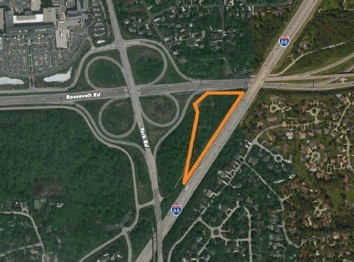
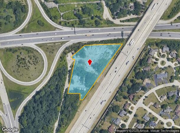
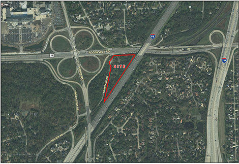
Property Record
15W321 Roosevelt Rd, Elmhurst, IL 60126

NEARBY LISTINGS FOR SALE OR LEASE
Property Detail
15W321 Roosevelt Rd
Chicago-Naperville-Elgin, IL-IN
J P O Connors Survey
06-24-200-002
PT N 1/2 NE 1/4 /SE OF RD/ DESC IN BK 133 OF DDS PG 186 /EX J P O CONNORS SURVEY/ /EX TOLLWAY T 6A 143.1 AND T 6A 143
Commercialnec
DuPage
X
Illinois
17043C0181J
4.64 AC
2024
Eastern East/West Corr
2024
Chicago
842900
DEMOGRAPHICS near 15W321 Roosevelt Rd
1 Mile
3 Mile
5 Mile
2024 Total Population
5,802
97,179
327,831
2029 Population
5,612
95,960
321,279
Pop Growth 2024-2029
(3.27%)
(1.25%)
(2.00%)
Average Age
45
43
41
2024 Total Households
2,418
36,576
117,599
HH Growth 2024-2029
(3.68%)
(1.40%)
(2.13%)
Median Household Inc
$102,441
$95,568
$91,265
Avg Household Size
2.30
2.60
2.70
2024 Avg HH Vehicles
2.00
2.00
2.00
Median Home Value
$450,958
$332,606
$322,119
Median Year Built
1972
1962
1959
Nearby Places
Map Layers
Map Styles
 Street
 Aerial
- Restaurants
- Banks
- Shops
- Fitness
- Groceries
PUBLIC TRANSPORTATION
COMMUTER RAIL
Elmhurst Station (Union Pacific West Line - Northeast Illinois Regional Commuter Railroad (Metra))
DRIVE
WALK
Distance
Elmhurst Station (Union Pacific West Line - Northeast Illinois Regional Commuter Railroad (Metra))
11 min
6.3 mi
Berkeley Station (Union Pacific West Line - Northeast Illinois Regional Commuter Railroad (Metra))
DRIVE
WALK
Distance
Berkeley Station (Union Pacific West Line - Northeast Illinois Regional Commuter Railroad (Metra))
13 min
7.5 mi
AIRPORT
Chicago Midway International
DRIVE
WALK
Distance
Chicago Midway International
24 min
14.8 mi
Chicago O'Hare International
DRIVE
WALK
Distance
Chicago O'Hare International
25 min
17.2 mi
Freight Ports
Port Milwaukee
DRIVE
WALK
Distance
Port Milwaukee
106 min
88.9 mi
SALE & LEASE HISTORY
LISTING DATE
SALE/LEASE

Sep 24, 2016
For Sale
Oct 19, 2018
For Sale
May 03, 2019
For Sale
Jun 18, 2018
For Sale
Nearby Properties
Address
Land Use
TOTAL SIZE
Lot Size
Zoning
Address
Land Use
TOTAL SIZE
Lot Size
Zoning
588,603 SF
11.92 AC
C
Address
Land Use
TOTAL SIZE
Lot Size
Zoning
345,161 SF
23.37 AC
C
Address
Land Use
TOTAL SIZE
Lot Size
Zoning
347,240 SF
1.18 AC
Address
Land Use
TOTAL SIZE
Lot Size
Zoning
4.69 AC
Address
Land Use
TOTAL SIZE
Lot Size
Zoning
435,740 SF
17.74 AC
C
Address
Land Use
TOTAL SIZE
Lot Size
Zoning
312,131 SF
13.66 AC
M
Address
Land Use
TOTAL SIZE
Lot Size
Zoning
268,057 SF
5.03 AC
C
Address
Land Use
TOTAL SIZE
Lot Size
Zoning
309,570 SF
1.02 AC
Address
Land Use
TOTAL SIZE
Lot Size
Zoning
15.17 AC
Address
Land Use
TOTAL SIZE
Lot Size
Zoning
740,508 SF
9.82 AC
C
Address
Land Use
TOTAL SIZE
Lot Size
Zoning
338,664 SF
11.42 AC
M
Address
Land Use
TOTAL SIZE
Lot Size
Zoning
313,920 SF
13.18 AC
M
Address
Land Use
TOTAL SIZE
Lot Size
Zoning
240,678 SF
19.83 AC
C
Address
Land Use
TOTAL SIZE
Lot Size
Zoning
440,000 SF
5.32 AC
C
Address
Land Use
TOTAL SIZE
Lot Size
Zoning
442,326 SF
12.47 AC
C
Address
Land Use
TOTAL SIZE
Lot Size
Zoning
240,073 SF
1.04 AC
Address
Land Use
TOTAL SIZE
Lot Size
Zoning
221,673 SF
4.49 AC
Address
Land Use
TOTAL SIZE
Lot Size
Zoning
973,922 SF
53.84 AC
I
Address
Land Use
TOTAL SIZE
Lot Size
Zoning
518,123 SF
18.20 AC
C
Address
Land Use
TOTAL SIZE
Lot Size
Zoning
271,822 SF
26.29 AC
Address
Land Use
TOTAL SIZE
Lot Size
Zoning
12.40 AC
Address
Land Use
TOTAL SIZE
Lot Size
Zoning
204,600 SF
9.45 AC
M
Address
Land Use
TOTAL SIZE
Lot Size
Zoning
54,675 SF
3.05 AC
C
Address
Land Use
TOTAL SIZE
Lot Size
Zoning
251,223 SF
5.71 AC
C
Address
Land Use
TOTAL SIZE
Lot Size
Zoning
84,205 SF
0.99 AC
C
Address
Land Use
TOTAL SIZE
Lot Size
Zoning
176,923 SF
9.22 AC
C
Address
Land Use
TOTAL SIZE
Lot Size
Zoning
438,818 SF
5.90 AC
Address
Land Use
TOTAL SIZE
Lot Size
Zoning
0.84 AC
Address
Land Use
TOTAL SIZE
Lot Size
Zoning
152,332 SF
3.60 AC
Address
Land Use
TOTAL SIZE
Lot Size
Zoning
80,072 SF
1.13 AC
C
The World's #1 Commercial Real Estate Marketplace
Connect with us
© 2026 CoStar Group
The information above has been obtained from sources believed reliable. While we do not doubt its accuracy we have not verified it and make no guarantee, warranty or representation about it. It is your responsibility to independently confirm its accuracy and completeness. Any projections, opinions, assumptions, or estimates used are for example only and do not represent the current or future performance of the property. The value of this transaction to you depends on tax and other factors which should be evaluated by your tax, financial, and legal advisors. You and your advisors should conduct a careful, independent investigation of the property to determine to your satisfaction the suitability of the property for your needs.