Property Record
16 2Nd St, Shelly, MN 56581

Save to a Folder
{{folder.Name}}
{{folder.ListingIds.length}} Properties
{{folder.ListingIds.length}} Property
Create a New Folder
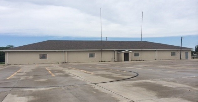
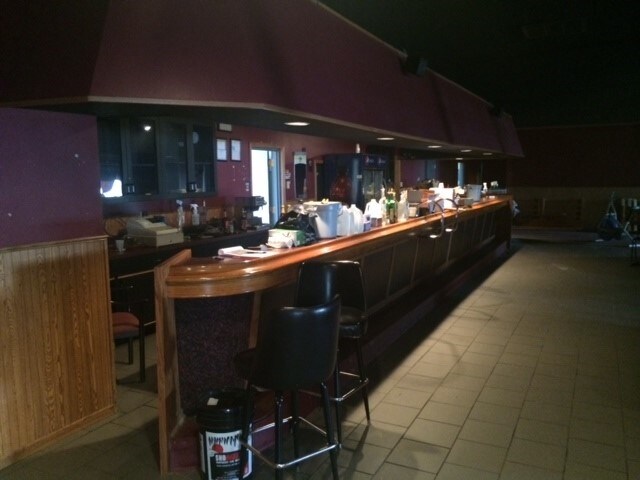
Property Detail
16 2Nd St
Nightclub
AC 5.41 COM. AT NE COR. SEC. 19, W 1,148.19 FT. TO POINT OF BEG. W 360.02 FT., S ERLY 686.1 FT., E ERLY, 342.8 FT
AE The base floodplain where base flood elevations are provided. AE Zones are now used on new format FIRMs instead of A1-A30 Zones.
NORMAN
2025
Minnesota
2025
5.41 AC
960200
Other Market Areas
9,600 SF
31-7358002
NEARBY LISTINGS FOR SALE OR LEASE
-
-
View all Shelly listings for sale on LoopNet.com
DEMOGRAPHICS near 16 2Nd St
1 mile
3 mile
5 mile
2025 Total Population
225
313
465
2030 Population
224
312
464
Pop Growth 2025-2030
(0.44%)
(0.32%)
(0.22%)
Average Age
45
44
43
2025 Total Households
95
129
188
HH Growth 2025-2030
0.00%
0.00%
(0.53%)
Median Household Inc
$66,750
$70,384
$73,676
Avg Household Size
2.30
2.30
2.40
2025 Avg HH Vehicles
2.00
2.00
2.00
Median Home Value
$139,705
$145,348
$157,017
Median Year Built
1962
1961
1959
Nearby Places
Map Layers
Map Styles
 Street
 Aerial
Layers
 Traffic
 Biking
Places
Listings with unknown addresses are not visible on the map
- Restaurants
- Banks
- Shops
- Fitness
- Groceries
PUBLIC TRANSPORTATION
AIRPORT
Grand Forks International
Drive
Walk
Distance
Grand Forks International
73 min
48.6 mi
Nearby Properties
Address
Land Use
TOTAL SIZE
Lot Size
Zoning
Address
Land Use
TOTAL SIZE
Lot Size
Zoning
307.12 AC
Address
Land Use
TOTAL SIZE
Lot Size
Zoning
160 AC
Address
Land Use
TOTAL SIZE
Lot Size
Zoning
Address
Land Use
TOTAL SIZE
Lot Size
Zoning
139.08 AC
Address
Land Use
TOTAL SIZE
Lot Size
Zoning
160 AC
Address
Land Use
TOTAL SIZE
Lot Size
Zoning
113.05 AC
Address
Land Use
TOTAL SIZE
Lot Size
Zoning
106.04 AC
Address
Land Use
TOTAL SIZE
Lot Size
Zoning
Address
Land Use
TOTAL SIZE
Lot Size
Zoning
Address
Land Use
TOTAL SIZE
Lot Size
Zoning
87.11 AC
Address
Land Use
TOTAL SIZE
Lot Size
Zoning
104.50 AC
Address
Land Use
TOTAL SIZE
Lot Size
Zoning
Address
Land Use
TOTAL SIZE
Lot Size
Zoning
80 AC
Address
Land Use
TOTAL SIZE
Lot Size
Zoning
95.68 AC
Address
Land Use
TOTAL SIZE
Lot Size
Zoning
96.63 AC
Address
Land Use
TOTAL SIZE
Lot Size
Zoning
76.10 AC
Address
Land Use
TOTAL SIZE
Lot Size
Zoning
41.90 AC
Address
Land Use
TOTAL SIZE
Lot Size
Zoning
1,006 SF
81.31 AC
Address
Land Use
TOTAL SIZE
Lot Size
Zoning
Address
Land Use
TOTAL SIZE
Lot Size
Zoning
17.53 AC
Address
Land Use
TOTAL SIZE
Lot Size
Zoning
26.20 AC
Address
Land Use
TOTAL SIZE
Lot Size
Zoning
40 AC
Address
Land Use
TOTAL SIZE
Lot Size
Zoning
Address
Land Use
TOTAL SIZE
Lot Size
Zoning
852 SF
32 AC
Address
Land Use
TOTAL SIZE
Lot Size
Zoning
22.25 AC
Address
Land Use
TOTAL SIZE
Lot Size
Zoning
Address
Land Use
TOTAL SIZE
Lot Size
Zoning
0.96 AC
Address
Land Use
TOTAL SIZE
Lot Size
Zoning
29.49 AC
Address
Land Use
TOTAL SIZE
Lot Size
Zoning
960 SF
23.25 AC
Address
Land Use
TOTAL SIZE
Lot Size
Zoning
0.32 AC
The World's #1 Commercial Real Estate Marketplace
Connect with us
© 2026 CoStar Group
The information above has been obtained from sources believed reliable. While we do not doubt its accuracy we have not verified it and make no guarantee, warranty or representation about it. It is your responsibility to independently confirm its accuracy and completeness. Any projections, opinions, assumptions, or estimates used are for example only and do not represent the current or future performance of the property. The value of this transaction to you depends on tax and other factors which should be evaluated by your tax, financial, and legal advisors. You and your advisors should conduct a careful, independent investigation of the property to determine to your satisfaction the suitability of the property for your needs.