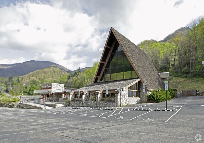
Property Record
16 Fie Top Rd, Maggie Valley, NC 28751


NEARBY LISTINGS FOR SALE OR LEASE
Property Detail
16 Fie Top Rd
7677-91-3975
Mb 878 Pg 1442
Storebuilding
16 FIE TOP RD
AE
Haywood
3700768700J
North Carolina
0
98.40 AC
2025
Haywood County
920701
Asheville
3,850 SF
Asheville, NC
DEMOGRAPHICS near 16 Fie Top Rd
1 Mile
3 Mile
5 Mile
2024 Total Population
1,156
3,975
8,470
2029 Population
1,227
4,226
8,946
Pop Growth 2024-2029
+ 6.14%
+ 6.31%
+ 5.62%
Average Age
53
53
51
2024 Total Households
530
1,900
4,015
HH Growth 2024-2029
+ 6.23%
+ 6.32%
+ 5.70%
Median Household Inc
$44,056
$48,899
$57,440
Avg Household Size
2.10
2.00
2.10
2024 Avg HH Vehicles
2.00
2.00
2.00
Median Home Value
$249,224
$248,195
$276,295
Median Year Built
1987
1989
1990
Nearby Places
Map Layers
Map Styles
 Street
 Aerial
- Restaurants
- Banks
- Shops
- Fitness
- Groceries
SALE & LEASE HISTORY
LISTING DATE
SALE/LEASE

Jul 15, 2019
For Sale
Apr 26, 2017
For Sale
Nearby Properties
Address
Land Use
TOTAL SIZE
Lot Size
Zoning
Address
Land Use
TOTAL SIZE
Lot Size
Zoning
1,239 SF
18.07 AC
Address
Land Use
TOTAL SIZE
Lot Size
Zoning
15,735 SF
119.65 AC
MR2
Address
Land Use
TOTAL SIZE
Lot Size
Zoning
546 SF
7.47 AC
Address
Land Use
TOTAL SIZE
Lot Size
Zoning
1,024 SF
105.10 AC
Address
Land Use
TOTAL SIZE
Lot Size
Zoning
14,352 SF
2.70 AC
Address
Land Use
TOTAL SIZE
Lot Size
Zoning
10,212 SF
1 AC
MC1
Address
Land Use
TOTAL SIZE
Lot Size
Zoning
13,498 SF
1.20 AC
MC1
Address
Land Use
TOTAL SIZE
Lot Size
Zoning
5,000 SF
1.75 AC
MC1
Address
Land Use
TOTAL SIZE
Lot Size
Zoning
4,753 SF
3.27 AC
MC1
Address
Land Use
TOTAL SIZE
Lot Size
Zoning
7,052 SF
3.35 AC
MC1
Address
Land Use
TOTAL SIZE
Lot Size
Zoning
13,303 SF
1.43 AC
MC1
Address
Land Use
TOTAL SIZE
Lot Size
Zoning
9,504 SF
1.22 AC
MC1
Address
Land Use
TOTAL SIZE
Lot Size
Zoning
10,110 SF
0.93 AC
MC1
Address
Land Use
TOTAL SIZE
Lot Size
Zoning
Address
Land Use
TOTAL SIZE
Lot Size
Zoning
1,064 SF
1.20 AC
MC1
Address
Land Use
TOTAL SIZE
Lot Size
Zoning
3,982 SF
1.81 AC
MC1
Address
Land Use
TOTAL SIZE
Lot Size
Zoning
11,712 SF
2.06 AC
MC1
Address
Land Use
TOTAL SIZE
Lot Size
Zoning
8,880 SF
1.45 AC
MC1
Address
Land Use
TOTAL SIZE
Lot Size
Zoning
295.26 AC
Address
Land Use
TOTAL SIZE
Lot Size
Zoning
5,568 SF
3.78 AC
MC1
Address
Land Use
TOTAL SIZE
Lot Size
Zoning
6,080 SF
2.01 AC
MC1
Address
Land Use
TOTAL SIZE
Lot Size
Zoning
3,484 SF
6.55 AC
Address
Land Use
TOTAL SIZE
Lot Size
Zoning
4,944 SF
1.11 AC
MC1
Address
Land Use
TOTAL SIZE
Lot Size
Zoning
1,710 SF
8.03 AC
Address
Land Use
TOTAL SIZE
Lot Size
Zoning
88.65 AC
Address
Land Use
TOTAL SIZE
Lot Size
Zoning
6,524 SF
1.88 AC
MC1
Address
Land Use
TOTAL SIZE
Lot Size
Zoning
2,016 SF
8.05 AC
Address
Land Use
TOTAL SIZE
Lot Size
Zoning
8,907 SF
4.24 AC
Address
Land Use
TOTAL SIZE
Lot Size
Zoning
445.50 AC
The World's #1 Commercial Real Estate Marketplace
Connect with us
© 2026 CoStar Group
The information above has been obtained from sources believed reliable. While we do not doubt its accuracy we have not verified it and make no guarantee, warranty or representation about it. It is your responsibility to independently confirm its accuracy and completeness. Any projections, opinions, assumptions, or estimates used are for example only and do not represent the current or future performance of the property. The value of this transaction to you depends on tax and other factors which should be evaluated by your tax, financial, and legal advisors. You and your advisors should conduct a careful, independent investigation of the property to determine to your satisfaction the suitability of the property for your needs.