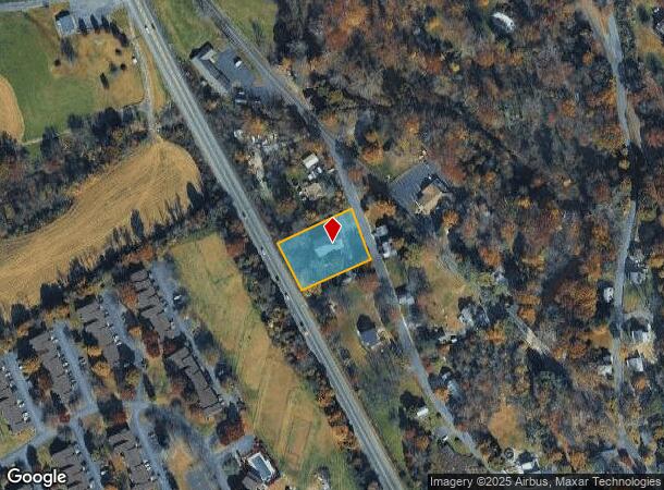
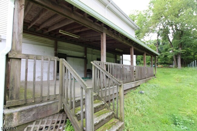
Property Record
16 Hampton Rd, Glen Gardner, NJ 08826
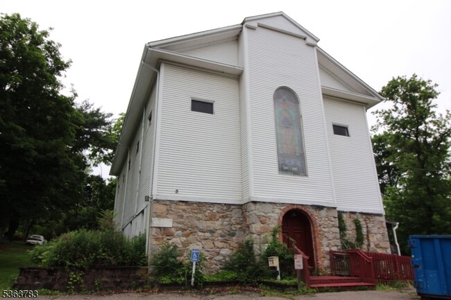
This Property Is For Sale
NEARBY LISTINGS FOR SALE OR LEASE
-
-
View all Glen Gardner listings for sale on LoopNet.com
Property Detail
16 Hampton Rd
Newark, NJ-PA
FACILITY NAME: RECREATION CENTER
12-00006-0000-00004
Hunterdon
Religious
New Jersey
X
4
34041C0329E
0.74 AC
0
Hunterdon
2025
Northern New Jersey
010300
DEMOGRAPHICS near 16 Hampton Rd
1 Mile
3 Mile
5 Mile
2024 Total Population
3,121
9,225
34,807
2029 Population
3,269
9,799
36,965
Pop Growth 2024-2029
+ 4.74%
+ 6.22%
+ 6.20%
Average Age
43
44
43
2024 Total Households
1,393
3,562
13,294
HH Growth 2024-2029
+ 4.95%
+ 6.49%
+ 6.51%
Median Household Inc
$81,109
$112,000
$101,103
Avg Household Size
2.20
2.50
2.50
2024 Avg HH Vehicles
2.00
2.00
2.00
Median Home Value
$300,452
$387,373
$345,669
Median Year Built
1976
1977
1973
Nearby Places
- Restaurants
- Banks
- Shops
- Fitness
- Groceries
PUBLIC TRANSPORTATION
COMMUTER RAIL
High Bridge (Raritan Valley Line - NJ Transit Commuter Rail (NJ Transit))
DRIVE
WALK
Distance
High Bridge (Raritan Valley Line - NJ Transit Commuter Rail (NJ Transit))
8 min
5.0 mi
Annandale (Raritan Valley Line - NJ Transit Commuter Rail (NJ Transit))
DRIVE
WALK
Distance
Annandale (Raritan Valley Line - NJ Transit Commuter Rail (NJ Transit))
11 min
6.9 mi
AIRPORT
Lehigh Valley International
DRIVE
WALK
Distance
Lehigh Valley International
53 min
32.8 mi
Trenton Mercer
DRIVE
WALK
Distance
Trenton Mercer
52 min
35.5 mi
Freight Ports
Maher Terminal
DRIVE
WALK
Distance
Maher Terminal
61 min
48.8 mi
Nearby Properties
Address
Land Use
TOTAL SIZE
Lot Size
Zoning
Address
Land Use
TOTAL SIZE
Lot Size
Zoning
52.10 AC
PCOS
Address
Land Use
TOTAL SIZE
Lot Size
Zoning
255.40 AC
WM
Address
Land Use
TOTAL SIZE
Lot Size
Zoning
215.75 AC
RC
Address
Land Use
TOTAL SIZE
Lot Size
Zoning
800 SF
28.04 AC
MR
Address
Land Use
TOTAL SIZE
Lot Size
Zoning
22.84 AC
HC
Address
Land Use
TOTAL SIZE
Lot Size
Zoning
6.24 AC
PVD
Address
Land Use
TOTAL SIZE
Lot Size
Zoning
3.98 AC
B-4
Address
Land Use
TOTAL SIZE
Lot Size
Zoning
8.97 AC
Address
Land Use
TOTAL SIZE
Lot Size
Zoning
1,280 SF
240.85 AC
PVD
Address
Land Use
TOTAL SIZE
Lot Size
Zoning
1.87 AC
PVD
Address
Land Use
TOTAL SIZE
Lot Size
Zoning
5.40 AC
OR
Address
Land Use
TOTAL SIZE
Lot Size
Zoning
25,440 SF
6.06 AC
B2
Address
Land Use
TOTAL SIZE
Lot Size
Zoning
5.50 AC
OR
Address
Land Use
TOTAL SIZE
Lot Size
Zoning
5.08 AC
HC
Address
Land Use
TOTAL SIZE
Lot Size
Zoning
5,752 SF
2.09 AC
RA
Address
Land Use
TOTAL SIZE
Lot Size
Zoning
203 AC
MR
Address
Land Use
TOTAL SIZE
Lot Size
Zoning
73.40 AC
G
Address
Land Use
TOTAL SIZE
Lot Size
Zoning
6.04 AC
HC
Address
Land Use
TOTAL SIZE
Lot Size
Zoning
1.98 AC
PVD
Address
Land Use
TOTAL SIZE
Lot Size
Zoning
1.70 AC
HC
Address
Land Use
TOTAL SIZE
Lot Size
Zoning
7,500 SF
6.05 AC
HC
Address
Land Use
TOTAL SIZE
Lot Size
Zoning
3 AC
B-2
Address
Land Use
TOTAL SIZE
Lot Size
Zoning
7,640 SF
1.87 AC
R1.5
Address
Land Use
TOTAL SIZE
Lot Size
Zoning
3.10 AC
C
Address
Land Use
TOTAL SIZE
Lot Size
Zoning
11,220 SF
4.06 AC
GA
Address
Land Use
TOTAL SIZE
Lot Size
Zoning
10,698 SF
2.35 AC
B1
Address
Land Use
TOTAL SIZE
Lot Size
Zoning
35 AC
I
Address
Land Use
TOTAL SIZE
Lot Size
Zoning
12,000 SF
3.70 AC
B2
Address
Land Use
TOTAL SIZE
Lot Size
Zoning
5,720 SF
17.47 AC
OR
Address
Land Use
TOTAL SIZE
Lot Size
Zoning
12,528 SF
14.83 AC
B1
The World's #1 Commercial Real Estate Marketplace
Connect with us
© 2025 CoStar Group
The information above has been obtained from sources believed reliable. While we do not doubt its accuracy we have not verified it and make no guarantee, warranty or representation about it. It is your responsibility to independently confirm its accuracy and completeness. Any projections, opinions, assumptions, or estimates used are for example only and do not represent the current or future performance of the property. The value of this transaction to you depends on tax and other factors which should be evaluated by your tax, financial, and legal advisors. You and your advisors should conduct a careful, independent investigation of the property to determine to your satisfaction the suitability of the property for your needs.