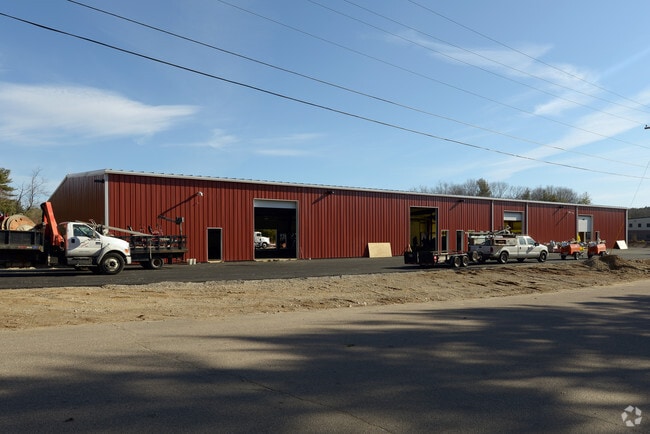
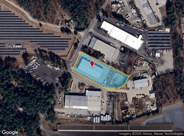
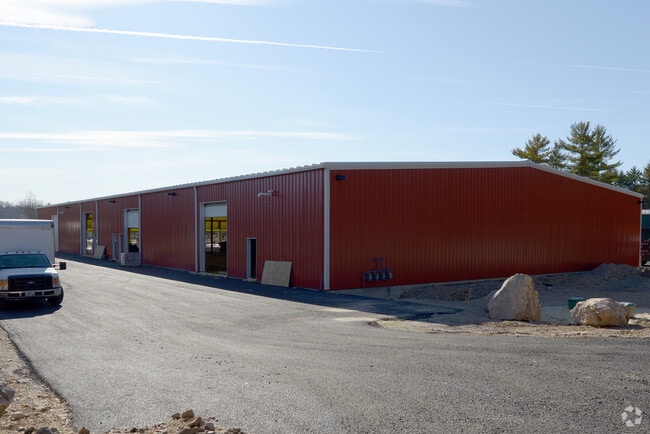
Property Record
16 High St, Plainville, MA 02762
NEARBY LISTINGS FOR SALE OR LEASE
Property Detail
16 High St
PLAI-000005-000000-000183
Norfolk
Commercialbuilding
Massachusetts
X
183
25021C0338F
2.30 AC
2025
I-95 Corridor South
2025
Boston
440102
Boston-Cambridge-Newton, MA-NH
22,000 SF
DEMOGRAPHICS near 16 High St
1 Mile
3 Mile
5 Mile
2024 Total Population
1,256
22,228
76,668
2029 Population
1,243
22,041
76,304
Pop Growth 2024-2029
(1.04%)
(0.84%)
(0.47%)
Average Age
41
42
41
2024 Total Households
443
9,011
29,331
HH Growth 2024-2029
(1.13%)
(0.93%)
(0.55%)
Median Household Inc
$135,937
$99,376
$112,935
Avg Household Size
2.80
2.40
2.60
2024 Avg HH Vehicles
2.00
2.00
2.00
Median Home Value
$586,666
$453,108
$477,586
Median Year Built
1979
1976
1978
Nearby Places
Map Layers
Map Styles
 Street
 Aerial
- Restaurants
- Banks
- Shops
- Fitness
- Groceries
PUBLIC TRANSPORTATION
COMMUTER RAIL
Franklin (Franklin Line - Massachusetts Bay Transportation Authority Commuter Rail (Purple Line))
DRIVE
WALK
Distance
Franklin (Franklin Line - Massachusetts Bay Transportation Authority Commuter Rail (Purple Line))
12 min
6.6 mi
Forge Park/Route 495 (Franklin Line - Massachusetts Bay Transportation Authority Commuter Rail (Purple Line))
DRIVE
WALK
Distance
Forge Park/Route 495 (Franklin Line - Massachusetts Bay Transportation Authority Commuter Rail (Purple Line))
13 min
8.2 mi
AIRPORT
Rhode Island Tf Green International
DRIVE
WALK
Distance
Rhode Island Tf Green International
47 min
25.9 mi
General Edward Lawrence Logan International
DRIVE
WALK
Distance
General Edward Lawrence Logan International
56 min
38.1 mi
Worcester Regional
DRIVE
WALK
Distance
Worcester Regional
61 min
41.3 mi
Freight Ports
Port of Boston
DRIVE
WALK
Distance
Port of Boston
54 min
32.7 mi
SALE & LEASE HISTORY
LISTING DATE
SALE/LEASE

Sep 25, 2016
For Lease
Oct 13, 2017
For Lease
Apr 05, 2017
For Lease
Nearby Properties
Address
Land Use
TOTAL SIZE
Lot Size
Zoning
Address
Land Use
TOTAL SIZE
Lot Size
Zoning
52,064 SF
87.51 AC
CI
Address
Land Use
TOTAL SIZE
Lot Size
Zoning
663,031 SF
44.44 AC
IB
Address
Land Use
TOTAL SIZE
Lot Size
Zoning
96,596 SF
17.01 AC
C-2 80
Address
Land Use
TOTAL SIZE
Lot Size
Zoning
5,022 SF
22.90 AC
RB
Address
Land Use
TOTAL SIZE
Lot Size
Zoning
13.93 AC
CB
Address
Land Use
TOTAL SIZE
Lot Size
Zoning
19,742 SF
58.34 AC
R-43
Address
Land Use
TOTAL SIZE
Lot Size
Zoning
232,152 SF
17.07 AC
Address
Land Use
TOTAL SIZE
Lot Size
Zoning
28.55 AC
CC
Address
Land Use
TOTAL SIZE
Lot Size
Zoning
176,269 SF
40.56 AC
B-2 80
Address
Land Use
TOTAL SIZE
Lot Size
Zoning
142,040 SF
18.16 AC
CI
Address
Land Use
TOTAL SIZE
Lot Size
Zoning
Address
Land Use
TOTAL SIZE
Lot Size
Zoning
22 AC
CI
Address
Land Use
TOTAL SIZE
Lot Size
Zoning
89,052 SF
17 AC
Address
Land Use
TOTAL SIZE
Lot Size
Zoning
72,331 SF
22.50 AC
Address
Land Use
TOTAL SIZE
Lot Size
Zoning
10,984 SF
8.52 AC
B-1 10
Address
Land Use
TOTAL SIZE
Lot Size
Zoning
6.88 AC
CA
Address
Land Use
TOTAL SIZE
Lot Size
Zoning
141,049 SF
22.77 AC
CI
Address
Land Use
TOTAL SIZE
Lot Size
Zoning
9,945 SF
16.72 AC
C-2 80
Address
Land Use
TOTAL SIZE
Lot Size
Zoning
1,656 SF
4.66 AC
R15
Address
Land Use
TOTAL SIZE
Lot Size
Zoning
102,591 SF
4.21 AC
R-43
Address
Land Use
TOTAL SIZE
Lot Size
Zoning
3.59 AC
IC3
Address
Land Use
TOTAL SIZE
Lot Size
Zoning
2,976 SF
9.83 AC
CC
Address
Land Use
TOTAL SIZE
Lot Size
Zoning
111,345 SF
3.52 AC
CA
Address
Land Use
TOTAL SIZE
Lot Size
Zoning
28,260 SF
2.89 AC
CA
Address
Land Use
TOTAL SIZE
Lot Size
Zoning
104,772 SF
2.29 AC
CA
Address
Land Use
TOTAL SIZE
Lot Size
Zoning
82,680 SF
22.54 AC
B-2 80
Address
Land Use
TOTAL SIZE
Lot Size
Zoning
9.76 AC
R15
Address
Land Use
TOTAL SIZE
Lot Size
Zoning
754 SF
278.53 AC
B-2 80
Address
Land Use
TOTAL SIZE
Lot Size
Zoning
5,784 SF
3.97 AC
B-1 10
Address
Land Use
TOTAL SIZE
Lot Size
Zoning
43,242 SF
15.50 AC
CB
The World's #1 Commercial Real Estate Marketplace
Connect with us
© 2025 CoStar Group
The information above has been obtained from sources believed reliable. While we do not doubt its accuracy we have not verified it and make no guarantee, warranty or representation about it. It is your responsibility to independently confirm its accuracy and completeness. Any projections, opinions, assumptions, or estimates used are for example only and do not represent the current or future performance of the property. The value of this transaction to you depends on tax and other factors which should be evaluated by your tax, financial, and legal advisors. You and your advisors should conduct a careful, independent investigation of the property to determine to your satisfaction the suitability of the property for your needs.