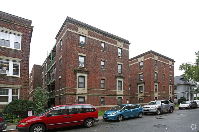
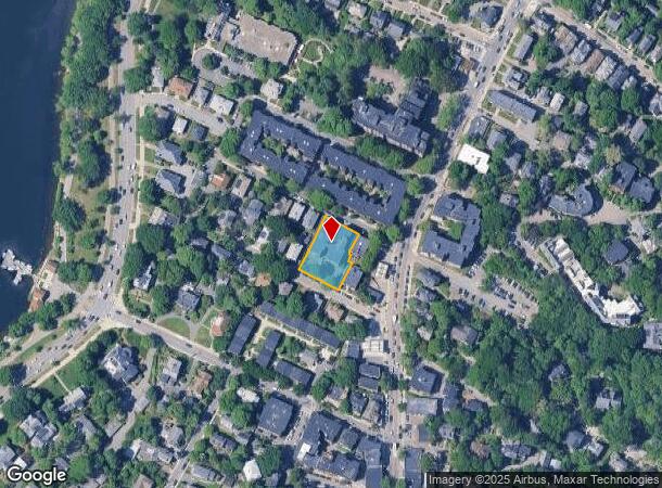
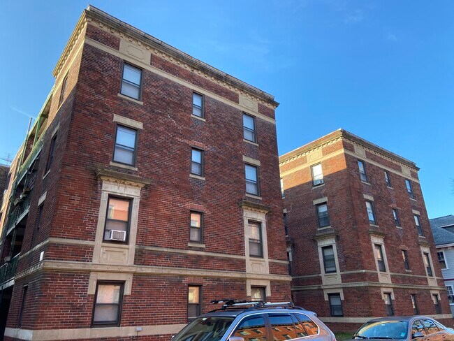
Property Record
16 Lakeville Rd, Jamaica Plain, MA 02130
NEARBY LISTINGS FOR SALE OR LEASE
Property Detail
16 Lakeville Rd
JAMA-000000-000019-001984
Pondside Condo
Apartment
Suffolk
X
Massachusetts
25021C0053F
0.40 AC
2025
Jamaica Hills-Pond
2025
Boston
120400
Boston-Cambridge-Newton, MA-NH
28,816 SF
DEMOGRAPHICS near 16 Lakeville Rd
1 Mile
3 Mile
5 Mile
2024 Total Population
39,099
412,092
854,891
2029 Population
36,940
394,741
823,826
Pop Growth 2024-2029
(5.52%)
(4.21%)
(3.63%)
Average Age
39
37
38
2024 Total Households
16,527
162,963
354,774
HH Growth 2024-2029
(6.16%)
(4.60%)
(3.90%)
Median Household Inc
$98,788
$72,673
$94,881
Avg Household Size
2.20
2.20
2.20
2024 Avg HH Vehicles
1.00
1.00
1.00
Median Home Value
$769,173
$785,256
$807,492
Median Year Built
1948
1949
1949
Nearby Places
Map Layers
Map Styles
 Street
 Aerial
- Restaurants
- Banks
- Shops
- Fitness
- Groceries
PUBLIC TRANSPORTATION
TRANSIT/SUBWAY
Green Street Station (Orange Line - Massachusetts Bay Transportation Authority Subway (The T))
DRIVE
WALK
Distance
Green Street Station (Orange Line - Massachusetts Bay Transportation Authority Subway (The T))
2 min
11 min
0.6 mi
Stony Brook Station (Orange Line - Massachusetts Bay Transportation Authority Subway (The T))
DRIVE
WALK
Distance
Stony Brook Station (Orange Line - Massachusetts Bay Transportation Authority Subway (The T))
4 min
13 min
0.7 mi
Heath Street Station (Green Line - E - Massachusetts Bay Transportation Authority Subway (The T))
DRIVE
WALK
Distance
Heath Street Station (Green Line - E - Massachusetts Bay Transportation Authority Subway (The T))
3 min
18 min
0.9 mi
Jackson Square Station (Orange Line - Massachusetts Bay Transportation Authority Subway (The T))
DRIVE
WALK
Distance
Jackson Square Station (Orange Line - Massachusetts Bay Transportation Authority Subway (The T))
3 min
20 min
1.0 mi
Back Of The Hill Station (Green Line - E - Massachusetts Bay Transportation Authority Subway (The T))
DRIVE
WALK
Distance
Back Of The Hill Station (Green Line - E - Massachusetts Bay Transportation Authority Subway (The T))
3 min
20 min
1.1 mi
COMMUTER RAIL
Forest Hills (Needham Line - Massachusetts Bay Transportation Authority Commuter Rail (Purple Line))
DRIVE
WALK
Distance
Forest Hills (Needham Line - Massachusetts Bay Transportation Authority Commuter Rail (Purple Line))
3 min
1.1 mi
Ruggles Station (Franklin Line - Massachusetts Bay Transportation Authority Commuter Rail (Purple Line), Needham Line - Massachusetts Bay Transportation Authority Commuter Rail (Purple Line), Orange Line - Massachusetts Bay Transportation Authority Commuter Rail (Purple Line), Providence/Stoughton Line - Massachusetts Bay Transportation Authority Commuter Rail (Purple Line))
DRIVE
WALK
Distance
Ruggles Station (Franklin Line - Massachusetts Bay Transportation Authority Commuter Rail (Purple Line), Needham Line - Massachusetts Bay Transportation Authority Commuter Rail (Purple Line), Orange Line - Massachusetts Bay Transportation Authority Commuter Rail (Purple Line), Providence/Stoughton Line - Massachusetts Bay Transportation Authority Commuter Rail (Purple Line))
6 min
2.6 mi
AIRPORT
General Edward Lawrence Logan International
DRIVE
WALK
Distance
General Edward Lawrence Logan International
17 min
8.1 mi
Freight Ports
Port of Boston
DRIVE
WALK
Distance
Port of Boston
15 min
6.4 mi
SALE & LEASE HISTORY
LISTING DATE
SALE/LEASE

Mar 09, 2020
For Sale
Nearby Properties
Address
Land Use
TOTAL SIZE
Lot Size
Zoning
Address
Land Use
TOTAL SIZE
Lot Size
Zoning
909,764 SF
25.13 AC
E
Address
Land Use
TOTAL SIZE
Lot Size
Zoning
610,560 SF
4.01 AC
E
Address
Land Use
TOTAL SIZE
Lot Size
Zoning
150,192 SF
10.27 AC
E
Address
Land Use
TOTAL SIZE
Lot Size
Zoning
596,972 SF
7.32 AC
E
Address
Land Use
TOTAL SIZE
Lot Size
Zoning
118,759 SF
0.92 AC
C
Address
Land Use
TOTAL SIZE
Lot Size
Zoning
3.52 AC
C-3
Address
Land Use
TOTAL SIZE
Lot Size
Zoning
377,634 SF
4.86 AC
E
Address
Land Use
TOTAL SIZE
Lot Size
Zoning
227,107 SF
7.70 AC
E
Address
Land Use
TOTAL SIZE
Lot Size
Zoning
254,208 SF
3.83 AC
E
Address
Land Use
TOTAL SIZE
Lot Size
Zoning
262,120 SF
0.62 AC
C
Address
Land Use
TOTAL SIZE
Lot Size
Zoning
547,851 SF
8.14 AC
E
Address
Land Use
TOTAL SIZE
Lot Size
Zoning
305,455 SF
0.54 AC
RC
Address
Land Use
TOTAL SIZE
Lot Size
Zoning
157,083 SF
0.41 AC
C
Address
Land Use
TOTAL SIZE
Lot Size
Zoning
136,025 SF
6.91 AC
C3
Address
Land Use
TOTAL SIZE
Lot Size
Zoning
303,055 SF
2.15 AC
RC
Address
Land Use
TOTAL SIZE
Lot Size
Zoning
269,232 SF
0.46 AC
C
Address
Land Use
TOTAL SIZE
Lot Size
Zoning
468,308 SF
0.78 AC
E
Address
Land Use
TOTAL SIZE
Lot Size
Zoning
443,356 SF
2.40 AC
C
Address
Land Use
TOTAL SIZE
Lot Size
Zoning
249,135 SF
1.99 AC
RC
Address
Land Use
TOTAL SIZE
Lot Size
Zoning
191,648 SF
0.65 AC
RC
Address
Land Use
TOTAL SIZE
Lot Size
Zoning
522,465 SF
5.34 AC
E
Address
Land Use
TOTAL SIZE
Lot Size
Zoning
76,658 SF
0.38 AC
E
Address
Land Use
TOTAL SIZE
Lot Size
Zoning
91,500 SF
1.03 AC
SD-5
Address
Land Use
TOTAL SIZE
Lot Size
Zoning
172,000 SF
0.31 AC
A
Address
Land Use
TOTAL SIZE
Lot Size
Zoning
208,468 SF
1.44 AC
RC
Address
Land Use
TOTAL SIZE
Lot Size
Zoning
268,675 SF
1.72 AC
I
Address
Land Use
TOTAL SIZE
Lot Size
Zoning
341,572 SF
1.71 AC
A
Address
Land Use
TOTAL SIZE
Lot Size
Zoning
147,997 SF
2.03 AC
GMR2
Address
Land Use
TOTAL SIZE
Lot Size
Zoning
225,241 SF
2.02 AC
E
Address
Land Use
TOTAL SIZE
Lot Size
Zoning
0.20 AC
E
The World's #1 Commercial Real Estate Marketplace
Connect with us
© 2025 CoStar Group
The information above has been obtained from sources believed reliable. While we do not doubt its accuracy we have not verified it and make no guarantee, warranty or representation about it. It is your responsibility to independently confirm its accuracy and completeness. Any projections, opinions, assumptions, or estimates used are for example only and do not represent the current or future performance of the property. The value of this transaction to you depends on tax and other factors which should be evaluated by your tax, financial, and legal advisors. You and your advisors should conduct a careful, independent investigation of the property to determine to your satisfaction the suitability of the property for your needs.