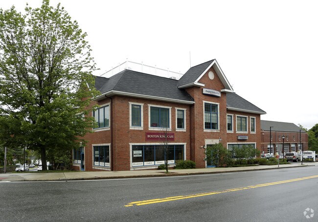
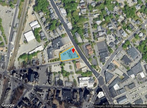
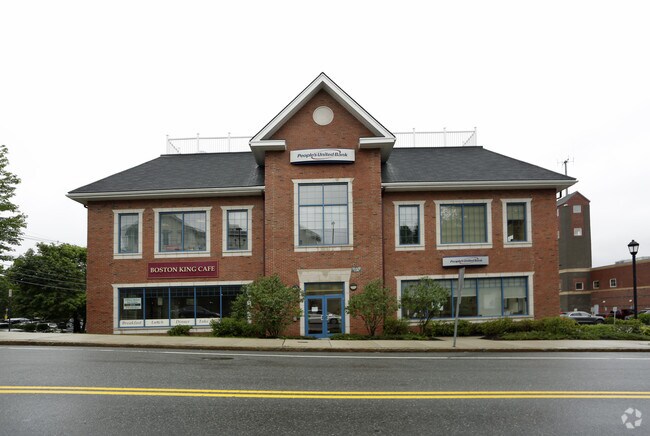
Property Record
16 N Main St, Andover, MA 01810

NEARBY LISTINGS FOR SALE OR LEASE
Property Detail
16 N Main St
ANDO-000038-000010
Andover
Financialbuilding
Essex
X
Massachusetts
25009C0217G
0.44 AC
2024
Lawrence/Andover
2024
Boston
254200
Boston-Cambridge-Newton, MA-NH
11,490 SF
DEMOGRAPHICS near 16 N Main St
1 mile
3 mile
5 mile
2024 Total Population
9,014
68,703
176,816
2029 Population
9,002
68,061
174,307
Pop Growth 2024-2029
(0.13%)
(0.93%)
(1.42%)
Average Age
41
39
38
2024 Total Households
3,451
24,079
61,020
HH Growth 2024-2029
(0.20%)
(0.97%)
(1.34%)
Median Household Inc
$127,538
$102,157
$81,355
Avg Household Size
2.30
2.70
2.70
2024 Avg HH Vehicles
2.00
2.00
2.00
Median Home Value
$726,145
$618,914
$555,669
Median Year Built
1951
1964
1964
Nearby Places
Map Layers
Map Styles
 Street
 Aerial
Transit
 Traffic
 Biking
Places
Listings with unknown addresses are not visible on the map
- Restaurants
- Banks
- Shops
- Fitness
- Groceries
PUBLIC TRANSPORTATION
TRANSIT/SUBWAY
Andover (Haverhill Line - Massachusetts Bay Transportation Authority Commuter Rail (Purple Line))
Drive
Walk
Distance
Andover (Haverhill Line - Massachusetts Bay Transportation Authority Commuter Rail (Purple Line))
2 min
4 min
0.2 mi
COMMUTER RAIL
Andover (Haverhill Line - Massachusetts Bay Transportation Authority Commuter Rail (Purple Line))
Drive
Walk
Distance
Andover (Haverhill Line - Massachusetts Bay Transportation Authority Commuter Rail (Purple Line))
1 min
5 min
0.3 mi
Ballardvale (Haverhill Line - Massachusetts Bay Transportation Authority Commuter Rail (Purple Line))
Drive
Walk
Distance
Ballardvale (Haverhill Line - Massachusetts Bay Transportation Authority Commuter Rail (Purple Line))
7 min
2.8 mi
AIRPORT
General Edward Lawrence Logan International
Drive
Walk
Distance
General Edward Lawrence Logan International
38 min
26.3 mi
Manchester Boston Regional
Drive
Walk
Distance
Manchester Boston Regional
46 min
31.4 mi
Portsmouth International at Pease
Drive
Walk
Distance
Portsmouth International at Pease
53 min
41.3 mi
Freight Ports
Port of Boston
Drive
Walk
Distance
Port of Boston
39 min
26.1 mi
SALE & LEASE HISTORY
LISTING DATE
SALE/LEASE

Sep 25, 2016
For Lease
Mar 21, 2017
For Lease
Apr 11, 2019
For Lease
Nearby Properties
Address
Land Use
TOTAL SIZE
Lot Size
Zoning
Address
Land Use
TOTAL SIZE
Lot Size
Zoning
102 AC
IA
Address
Land Use
TOTAL SIZE
Lot Size
Zoning
9,576 SF
56.95 AC
R3
Address
Land Use
TOTAL SIZE
Lot Size
Zoning
3,111 SF
42.18 AC
R5
Address
Land Use
TOTAL SIZE
Lot Size
Zoning
0.24 AC
SRC
Address
Land Use
TOTAL SIZE
Lot Size
Zoning
44.42 AC
LS
Address
Land Use
TOTAL SIZE
Lot Size
Zoning
15,621 SF
34 AC
R5
Address
Land Use
TOTAL SIZE
Lot Size
Zoning
16.56 AC
Address
Land Use
TOTAL SIZE
Lot Size
Zoning
314,278 SF
595.78 AC
SRB
Address
Land Use
TOTAL SIZE
Lot Size
Zoning
263.15 AC
SRB
Address
Land Use
TOTAL SIZE
Lot Size
Zoning
170,116 SF
11.14 AC
Address
Land Use
TOTAL SIZE
Lot Size
Zoning
509.76 AC
IA
Address
Land Use
TOTAL SIZE
Lot Size
Zoning
308.52 AC
IA
Address
Land Use
TOTAL SIZE
Lot Size
Zoning
71,785 SF
29 AC
R4
Address
Land Use
TOTAL SIZE
Lot Size
Zoning
140,376 SF
2,026.22 AC
SRB
Address
Land Use
TOTAL SIZE
Lot Size
Zoning
7.13 AC
Address
Land Use
TOTAL SIZE
Lot Size
Zoning
8,738 SF
30.59 AC
R4
Address
Land Use
TOTAL SIZE
Lot Size
Zoning
0.13 AC
MU
Address
Land Use
TOTAL SIZE
Lot Size
Zoning
14 AC
SRB
Address
Land Use
TOTAL SIZE
Lot Size
Zoning
169,008 SF
33.35 AC
VC
Address
Land Use
TOTAL SIZE
Lot Size
Zoning
6.84 AC
Address
Land Use
TOTAL SIZE
Lot Size
Zoning
2,552 SF
14.23 AC
Address
Land Use
TOTAL SIZE
Lot Size
Zoning
224.38 AC
SRB
Address
Land Use
TOTAL SIZE
Lot Size
Zoning
150,000 SF
30.73 AC
LS
Address
Land Use
TOTAL SIZE
Lot Size
Zoning
232,908 SF
12.74 AC
B3
Address
Land Use
TOTAL SIZE
Lot Size
Zoning
129,522 SF
20.22 AC
SRB
Address
Land Use
TOTAL SIZE
Lot Size
Zoning
26.60 AC
Address
Land Use
TOTAL SIZE
Lot Size
Zoning
3.44 AC
Address
Land Use
TOTAL SIZE
Lot Size
Zoning
7,344 SF
7.90 AC
Address
Land Use
TOTAL SIZE
Lot Size
Zoning
30,240 SF
5.78 AC
LS
Address
Land Use
TOTAL SIZE
Lot Size
Zoning
92,872 SF
0.93 AC
The World's #1 Commercial Real Estate Marketplace
Connect with us
© 2026 CoStar Group
The information above has been obtained from sources believed reliable. While we do not doubt its accuracy we have not verified it and make no guarantee, warranty or representation about it. It is your responsibility to independently confirm its accuracy and completeness. Any projections, opinions, assumptions, or estimates used are for example only and do not represent the current or future performance of the property. The value of this transaction to you depends on tax and other factors which should be evaluated by your tax, financial, and legal advisors. You and your advisors should conduct a careful, independent investigation of the property to determine to your satisfaction the suitability of the property for your needs.