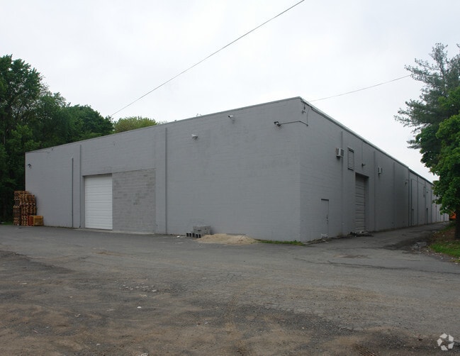
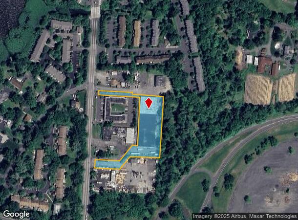
Property Record
16 N Route 9W, Congers, NY 10920

NEARBY LISTINGS FOR SALE OR LEASE
Property Detail
16 N Route 9W
392089-044-016-0003-059-000-0000
141-A-6.5
Warehouse
Rockland
A
New York
36087C0118G
59.0
2023
1.70 AC
2024
Rockland County
010902
Northern New Jersey
31,120 SF
New York-Jersey City-White Plains, NY-NJ
DEMOGRAPHICS near 16 N Route 9W
1 Mile
3 Mile
5 Mile
2024 Total Population
5,011
26,075
127,265
2029 Population
4,964
25,919
125,536
Pop Growth 2024-2029
(0.94%)
(0.60%)
(1.36%)
Average Age
42
43
42
2024 Total Households
1,724
8,849
44,535
HH Growth 2024-2029
(0.99%)
(0.62%)
(1.43%)
Median Household Inc
$123,073
$125,420
$114,198
Avg Household Size
2.80
2.90
2.70
2024 Avg HH Vehicles
2.00
2.00
2.00
Median Home Value
$457,060
$547,268
$541,637
Median Year Built
1975
1969
1965
Nearby Places
- Restaurants
- Banks
- Shops
- Fitness
- Groceries
PUBLIC TRANSPORTATION
AIRPORT
Westchester County
DRIVE
WALK
Distance
Westchester County
33 min
23.3 mi
New York Stewart International
DRIVE
WALK
Distance
New York Stewart International
51 min
34.3 mi
LaGuardia
DRIVE
WALK
Distance
LaGuardia
53 min
36.0 mi
Freight Ports
NY - Red Hook Container Terminal
DRIVE
WALK
Distance
NY - Red Hook Container Terminal
64 min
39.8 mi
Nearby Properties
Address
Land Use
TOTAL SIZE
Lot Size
Zoning
Address
Land Use
TOTAL SIZE
Lot Size
Zoning
2.67 AC
Address
Land Use
TOTAL SIZE
Lot Size
Zoning
5.88 AC
Address
Land Use
TOTAL SIZE
Lot Size
Zoning
19.20 AC
Address
Land Use
TOTAL SIZE
Lot Size
Zoning
21 AC
Address
Land Use
TOTAL SIZE
Lot Size
Zoning
247,711 SF
37.26 AC
Address
Land Use
TOTAL SIZE
Lot Size
Zoning
201.67 AC
Address
Land Use
TOTAL SIZE
Lot Size
Zoning
Address
Land Use
TOTAL SIZE
Lot Size
Zoning
Address
Land Use
TOTAL SIZE
Lot Size
Zoning
100,800 SF
13.40 AC
02 - SINGL
Address
Land Use
TOTAL SIZE
Lot Size
Zoning
130,930 SF
11 AC
Address
Land Use
TOTAL SIZE
Lot Size
Zoning
248,709 SF
15.30 AC
Address
Land Use
TOTAL SIZE
Lot Size
Zoning
99,725 SF
17.78 AC
03 - MULTI
Address
Land Use
TOTAL SIZE
Lot Size
Zoning
74.45 AC
166
Address
Land Use
TOTAL SIZE
Lot Size
Zoning
35,921 SF
6.10 AC
02 - SINGL
Address
Land Use
TOTAL SIZE
Lot Size
Zoning
8.94 AC
Address
Land Use
TOTAL SIZE
Lot Size
Zoning
51,445 SF
12.70 AC
Address
Land Use
TOTAL SIZE
Lot Size
Zoning
111,550 SF
9.29 AC
LI
Address
Land Use
TOTAL SIZE
Lot Size
Zoning
81,780 SF
7.52 AC
Address
Land Use
TOTAL SIZE
Lot Size
Zoning
30,679 SF
39 AC
Address
Land Use
TOTAL SIZE
Lot Size
Zoning
92,695 SF
5.42 AC
05
Address
Land Use
TOTAL SIZE
Lot Size
Zoning
72,080 SF
6.23 AC
Address
Land Use
TOTAL SIZE
Lot Size
Zoning
33,489 SF
47.55 AC
Address
Land Use
TOTAL SIZE
Lot Size
Zoning
2.16 AC
Address
Land Use
TOTAL SIZE
Lot Size
Zoning
61,100 SF
5.20 AC
02 - SINGL
Address
Land Use
TOTAL SIZE
Lot Size
Zoning
72,380 SF
2.95 AC
Address
Land Use
TOTAL SIZE
Lot Size
Zoning
37,560 SF
7.60 AC
Address
Land Use
TOTAL SIZE
Lot Size
Zoning
73,027 SF
35.69 AC
Address
Land Use
TOTAL SIZE
Lot Size
Zoning
42,055 SF
11 AC
Address
Land Use
TOTAL SIZE
Lot Size
Zoning
58,444 SF
3.50 AC
R1
Address
Land Use
TOTAL SIZE
Lot Size
Zoning
76,093 SF
4.80 AC
LI
The World's #1 Commercial Real Estate Marketplace
Connect with us
© 2025 CoStar Group
The information above has been obtained from sources believed reliable. While we do not doubt its accuracy we have not verified it and make no guarantee, warranty or representation about it. It is your responsibility to independently confirm its accuracy and completeness. Any projections, opinions, assumptions, or estimates used are for example only and do not represent the current or future performance of the property. The value of this transaction to you depends on tax and other factors which should be evaluated by your tax, financial, and legal advisors. You and your advisors should conduct a careful, independent investigation of the property to determine to your satisfaction the suitability of the property for your needs.