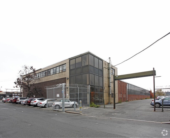
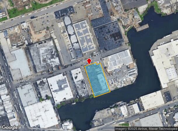
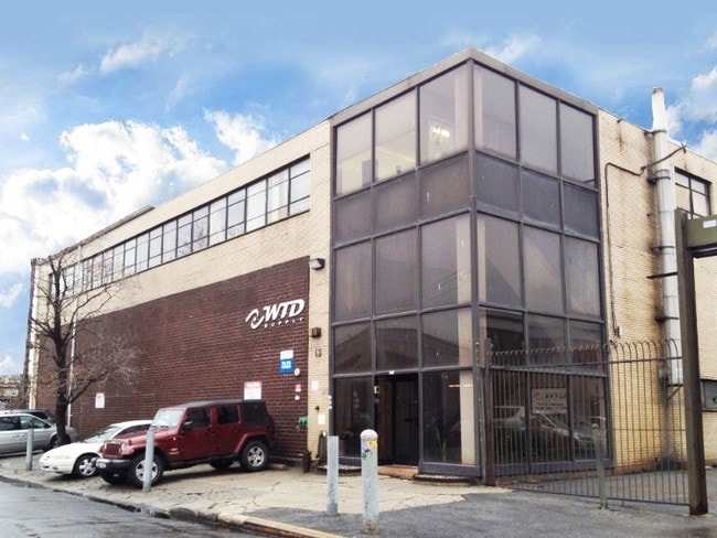
Property Record
16 Rewe St, Brooklyn, NY 11211

NEARBY LISTINGS FOR SALE OR LEASE
Property Detail
16 Rewe St
02927-0325
DOCID-2013091100325001
Warehouse
Kings
AE
New York
3604970208F
325
2024
1.25 AC
2025
North Brooklyn
044902
Long Island (New York)
46,500 SF
New York-Jersey City-White Plains, NY-NJ
DEMOGRAPHICS near 16 Rewe St
1 Mile
3 Mile
5 Mile
2024 Total Population
65,594
1,055,698
3,261,298
2029 Population
62,177
994,187
3,055,563
Pop Growth 2024-2029
(5.21%)
(5.83%)
(6.31%)
Average Age
37
37
39
2024 Total Households
27,857
421,863
1,371,471
HH Growth 2024-2029
(5.81%)
(6.19%)
(6.58%)
Median Household Inc
$80,672
$76,046
$84,887
Avg Household Size
2.30
2.40
2.30
2024 Avg HH Vehicles
.00
.00
.00
Median Home Value
$956,543
$849,216
$859,547
Median Year Built
1948
1949
1951
Nearby Places
- Restaurants
- Banks
- Shops
- Fitness
- Groceries
PUBLIC TRANSPORTATION
TRANSIT/SUBWAY
Grand Street (L Line) (L - New York MTA Subway (The Subway))
DRIVE
WALK
Distance
Grand Street (L Line) (L - New York MTA Subway (The Subway))
2 min
13 min
0.7 mi
Graham Avenue (L - New York MTA Subway (The Subway))
DRIVE
WALK
Distance
Graham Avenue (L - New York MTA Subway (The Subway))
2 min
15 min
0.8 mi
Morgan Avenue (L - New York MTA Subway (The Subway))
DRIVE
WALK
Distance
Morgan Avenue (L - New York MTA Subway (The Subway))
4 min
17 min
0.9 mi
Montrose Avenue (L - New York MTA Subway (The Subway))
DRIVE
WALK
Distance
Montrose Avenue (L - New York MTA Subway (The Subway))
3 min
19 min
1.0 mi
COMMUTER RAIL
Hunterspoint Avenue Station (Hempstead Branch - Long Island Rail Road, Oyster Bay Branch - Long Island Rail Road)
DRIVE
WALK
Distance
Hunterspoint Avenue Station (Hempstead Branch - Long Island Rail Road, Oyster Bay Branch - Long Island Rail Road)
7 min
2.9 mi
Long Island City Station (Hempstead Branch - Long Island Rail Road)
DRIVE
WALK
Distance
Long Island City Station (Hempstead Branch - Long Island Rail Road)
9 min
3.4 mi
AIRPORT
LaGuardia
DRIVE
WALK
Distance
LaGuardia
13 min
6.6 mi
John F Kennedy International
DRIVE
WALK
Distance
John F Kennedy International
22 min
12.2 mi
Newark Liberty International
DRIVE
WALK
Distance
Newark Liberty International
29 min
16.1 mi
Freight Ports
NY - Red Hook Container Terminal
DRIVE
WALK
Distance
NY - Red Hook Container Terminal
12 min
5.9 mi
Nearby Properties
Address
Land Use
TOTAL SIZE
Lot Size
Zoning
Address
Land Use
TOTAL SIZE
Lot Size
Zoning
8,462,176 SF
61.41 AC
R7-2
Address
Land Use
TOTAL SIZE
Lot Size
Zoning
2,812,739 SF
2.10 AC
C5-3
Address
Land Use
TOTAL SIZE
Lot Size
Zoning
2,124,441 SF
17.29 AC
R8
Address
Land Use
TOTAL SIZE
Lot Size
Zoning
1,104,505 SF
2.32 AC
C4-7
Address
Land Use
TOTAL SIZE
Lot Size
Zoning
7,058,736 SF
147.61 AC
M3-1
Address
Land Use
TOTAL SIZE
Lot Size
Zoning
3,122,165 SF
19.02 AC
R7-2
Address
Land Use
TOTAL SIZE
Lot Size
Zoning
1,065,915 SF
2.13 AC
M16R10
Address
Land Use
TOTAL SIZE
Lot Size
Zoning
1,385,425 SF
6.43 AC
R8
Address
Land Use
TOTAL SIZE
Lot Size
Zoning
840,000 SF
1.04 AC
C4-6
Address
Land Use
TOTAL SIZE
Lot Size
Zoning
1,503,235 SF
5.28 AC
C2-7
Address
Land Use
TOTAL SIZE
Lot Size
Zoning
805,287 SF
1 AC
R10
Address
Land Use
TOTAL SIZE
Lot Size
Zoning
2,948,300 SF
27.71 AC
R7-2
Address
Land Use
TOTAL SIZE
Lot Size
Zoning
984,760 SF
2.04 AC
M3-1
Address
Land Use
TOTAL SIZE
Lot Size
Zoning
818,726 SF
1.65 AC
C1-9
Address
Land Use
TOTAL SIZE
Lot Size
Zoning
383,780 SF
C6-2
Address
Land Use
TOTAL SIZE
Lot Size
Zoning
1,359,110 SF
1.89 AC
C5-3
Address
Land Use
TOTAL SIZE
Lot Size
Zoning
722,817 SF
3.26 AC
R8
Address
Land Use
TOTAL SIZE
Lot Size
Zoning
823,085 SF
R8
Address
Land Use
TOTAL SIZE
Lot Size
Zoning
1,658,649 SF
15.93 AC
R7-2
Address
Land Use
TOTAL SIZE
Lot Size
Zoning
835,231 SF
11.32 AC
R6
Address
Land Use
TOTAL SIZE
Lot Size
Zoning
410,239 SF
0.77 AC
R10
Address
Land Use
TOTAL SIZE
Lot Size
Zoning
198,380 SF
0.57 AC
R8
Address
Land Use
TOTAL SIZE
Lot Size
Zoning
751,223 SF
2.57 AC
R6
Address
Land Use
TOTAL SIZE
Lot Size
Zoning
512,755 SF
1.19 AC
R6
Address
Land Use
TOTAL SIZE
Lot Size
Zoning
882,579 SF
0.51 AC
M16R10
Address
Land Use
TOTAL SIZE
Lot Size
Zoning
550,232 SF
1.68 AC
R7-2
Address
Land Use
TOTAL SIZE
Lot Size
Zoning
684,862 SF
1.65 AC
M3-1
Address
Land Use
TOTAL SIZE
Lot Size
Zoning
4.44 AC
C5-2
Address
Land Use
TOTAL SIZE
Lot Size
Zoning
505,416 SF
M16R10
Address
Land Use
TOTAL SIZE
Lot Size
Zoning
710,860 SF
1.52 AC
M15R9
The World's #1 Commercial Real Estate Marketplace
Connect with us
© 2025 CoStar Group
The information above has been obtained from sources believed reliable. While we do not doubt its accuracy we have not verified it and make no guarantee, warranty or representation about it. It is your responsibility to independently confirm its accuracy and completeness. Any projections, opinions, assumptions, or estimates used are for example only and do not represent the current or future performance of the property. The value of this transaction to you depends on tax and other factors which should be evaluated by your tax, financial, and legal advisors. You and your advisors should conduct a careful, independent investigation of the property to determine to your satisfaction the suitability of the property for your needs.