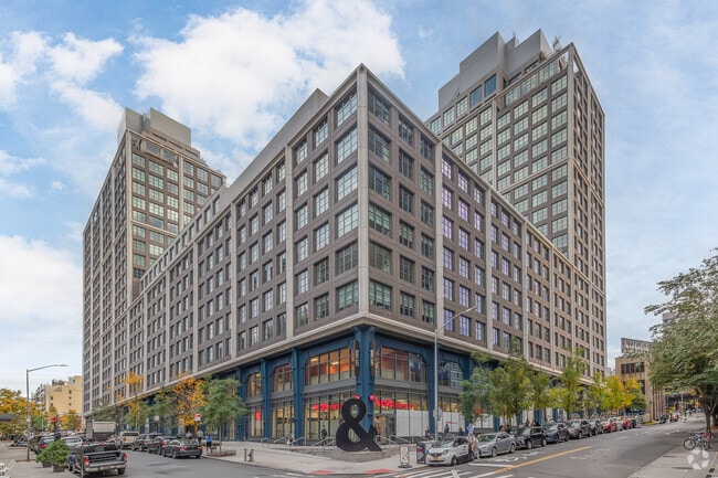
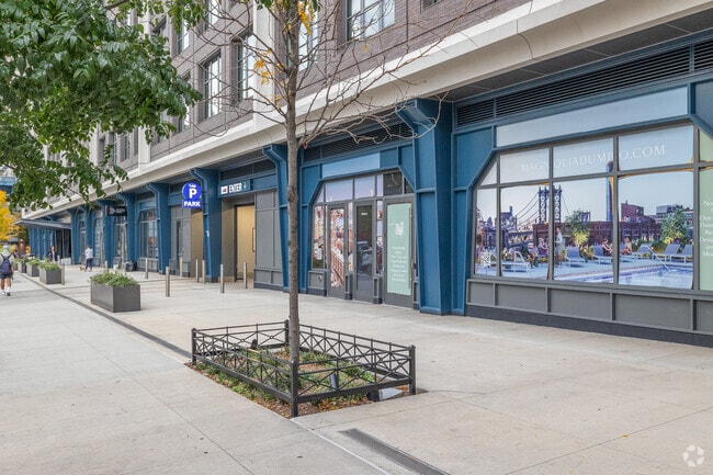
Property Record
160 Front St, Brooklyn, NY 11201
NEARBY LISTINGS FOR SALE OR LEASE
Property Detail
160 Front St
New York-Jersey City-White Plains, NY-NJ
Kings
00054-1001
New York
Condominium
1182
2024
3.10 AC
2025
DUMBO
002100
Long Island (New York)
312,821 SF
DEMOGRAPHICS near 160 Front St
1 mile
3 mile
5 mile
2024 Total Population
131,658
1,166,274
2,775,971
2029 Population
125,908
1,104,041
2,620,156
Pop Growth 2024-2029
(4.37%)
(5.34%)
(5.61%)
Average Age
41
38
38
2024 Total Households
60,420
526,159
1,185,068
HH Growth 2024-2029
(4.54%)
(5.78%)
(5.91%)
Median Household Inc
$88,445
$102,817
$89,042
Avg Household Size
2.10
2.10
2.20
2024 Avg HH Vehicles
.00
.00
.00
Median Home Value
$905,116
$1,018,977
$913,116
Median Year Built
1957
1949
1951
Nearby Places
Map Layers
Map Styles
 Street
 Aerial
Transit
 Traffic
 Biking
Places
Listings with unknown addresses are not visible on the map
- Restaurants
- Banks
- Shops
- Fitness
- Groceries
PUBLIC TRANSPORTATION
TRANSIT/SUBWAY
York Street (F - New York MTA Subway (The Subway))
Drive
Walk
Distance
York Street (F - New York MTA Subway (The Subway))
1 min
1 min
0.1 mi
High Street (A - New York MTA Subway (The Subway), C - New York MTA Subway (The Subway))
Drive
Walk
Distance
High Street (A - New York MTA Subway (The Subway), C - New York MTA Subway (The Subway))
3 min
7 min
0.4 mi
Borough Hall-Court Street (2 - New York MTA Subway (The Subway), 3 - New York MTA Subway (The Subway), 4 - New York MTA Subway (The Subway), 5 - New York MTA Subway (The Subway), M - New York MTA Subway (The Subway), N - New York MTA Subway (The Subway), R - New York MTA Subway (The Subway))
Drive
Walk
Distance
Borough Hall-Court Street (2 - New York MTA Subway (The Subway), 3 - New York MTA Subway (The Subway), 4 - New York MTA Subway (The Subway), 5 - New York MTA Subway (The Subway), M - New York MTA Subway (The Subway), N - New York MTA Subway (The Subway), R - New York MTA Subway (The Subway))
4 min
10 min
0.5 mi
Clark Street (2 - New York MTA Subway (The Subway), 3 - New York MTA Subway (The Subway))
Drive
Walk
Distance
Clark Street (2 - New York MTA Subway (The Subway), 3 - New York MTA Subway (The Subway))
5 min
12 min
0.7 mi
Jay Street-Borough Hall (A - New York MTA Subway (The Subway), C - New York MTA Subway (The Subway), F - New York MTA Subway (The Subway))
Drive
Walk
Distance
Jay Street-Borough Hall (A - New York MTA Subway (The Subway), C - New York MTA Subway (The Subway), F - New York MTA Subway (The Subway))
5 min
12 min
0.7 mi
COMMUTER RAIL
Long Island City Station (Hempstead Branch - Long Island Rail Road)
Drive
Walk
Distance
Long Island City Station (Hempstead Branch - Long Island Rail Road)
16 min
7.6 mi
AIRPORT
LaGuardia
Drive
Walk
Distance
LaGuardia
14 min
10.3 mi
Newark Liberty International
Drive
Walk
Distance
Newark Liberty International
25 min
14.6 mi
John F Kennedy International
Drive
Walk
Distance
John F Kennedy International
22 min
17.2 mi
Nearby Properties
Address
Land Use
TOTAL SIZE
Lot Size
Zoning
Address
Land Use
TOTAL SIZE
Lot Size
Zoning
8,462,176 SF
61.41 AC
R7-2
Address
Land Use
TOTAL SIZE
Lot Size
Zoning
2,161,994 SF
3.79 AC
M1-5
Address
Land Use
TOTAL SIZE
Lot Size
Zoning
2,354,289 SF
3.96 AC
C6-4
Address
Land Use
TOTAL SIZE
Lot Size
Zoning
2,812,739 SF
2.10 AC
C5-3
Address
Land Use
TOTAL SIZE
Lot Size
Zoning
2.38 AC
Address
Land Use
TOTAL SIZE
Lot Size
Zoning
1.75 AC
Address
Land Use
TOTAL SIZE
Lot Size
Zoning
2,157,862 SF
2.23 AC
BPC
Address
Land Use
TOTAL SIZE
Lot Size
Zoning
1,009,855 SF
4.90 AC
C6-3
Address
Land Use
TOTAL SIZE
Lot Size
Zoning
2,255,659 SF
4.58 AC
BPC
Address
Land Use
TOTAL SIZE
Lot Size
Zoning
8.22 AC
R8
Address
Land Use
TOTAL SIZE
Lot Size
Zoning
8.22 AC
R8
Address
Land Use
TOTAL SIZE
Lot Size
Zoning
2,124,441 SF
17.29 AC
R8
Address
Land Use
TOTAL SIZE
Lot Size
Zoning
Address
Land Use
TOTAL SIZE
Lot Size
Zoning
1,009,855 SF
3.25 AC
C6-3
Address
Land Use
TOTAL SIZE
Lot Size
Zoning
6.42 AC
Address
Land Use
TOTAL SIZE
Lot Size
Zoning
2,233,692 SF
1.90 AC
BPC
Address
Land Use
TOTAL SIZE
Lot Size
Zoning
1,233,394 SF
1.78 AC
C5-3
Address
Land Use
TOTAL SIZE
Lot Size
Zoning
2.21 AC
Address
Land Use
TOTAL SIZE
Lot Size
Zoning
1,104,505 SF
2.32 AC
C4-7
Address
Land Use
TOTAL SIZE
Lot Size
Zoning
1,560,607 SF
2.69 AC
C6-6
Address
Land Use
TOTAL SIZE
Lot Size
Zoning
1,636,000 SF
1.09 AC
C6-4
Address
Land Use
TOTAL SIZE
Lot Size
Zoning
1,909,502 SF
2.37 AC
BPC
Address
Land Use
TOTAL SIZE
Lot Size
Zoning
940,000 SF
1.44 AC
C6-2
Address
Land Use
TOTAL SIZE
Lot Size
Zoning
5.12 AC
C6-1G
Address
Land Use
TOTAL SIZE
Lot Size
Zoning
5.12 AC
C6-1G
Address
Land Use
TOTAL SIZE
Lot Size
Zoning
5.12 AC
C6-1G
Address
Land Use
TOTAL SIZE
Lot Size
Zoning
5.12 AC
C6-1G
Address
Land Use
TOTAL SIZE
Lot Size
Zoning
5.12 AC
C6-1G
Address
Land Use
TOTAL SIZE
Lot Size
Zoning
5.12 AC
C6-1G
Address
Land Use
TOTAL SIZE
Lot Size
Zoning
5.12 AC
C6-1G
The World's #1 Commercial Real Estate Marketplace
Connect with us
© 2026 CoStar Group
The information above has been obtained from sources believed reliable. While we do not doubt its accuracy we have not verified it and make no guarantee, warranty or representation about it. It is your responsibility to independently confirm its accuracy and completeness. Any projections, opinions, assumptions, or estimates used are for example only and do not represent the current or future performance of the property. The value of this transaction to you depends on tax and other factors which should be evaluated by your tax, financial, and legal advisors. You and your advisors should conduct a careful, independent investigation of the property to determine to your satisfaction the suitability of the property for your needs.