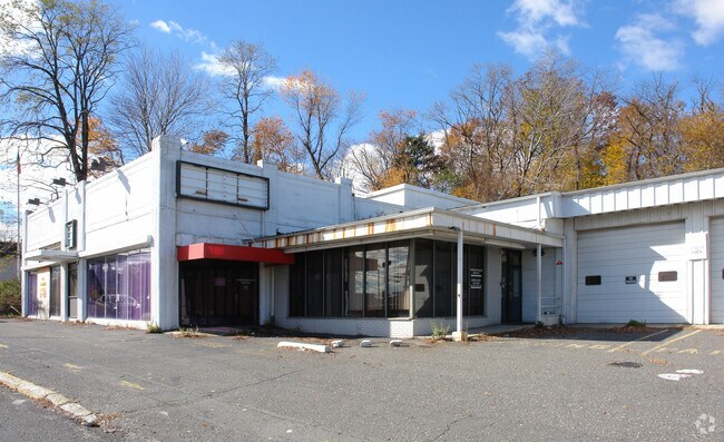
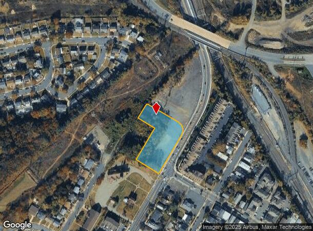
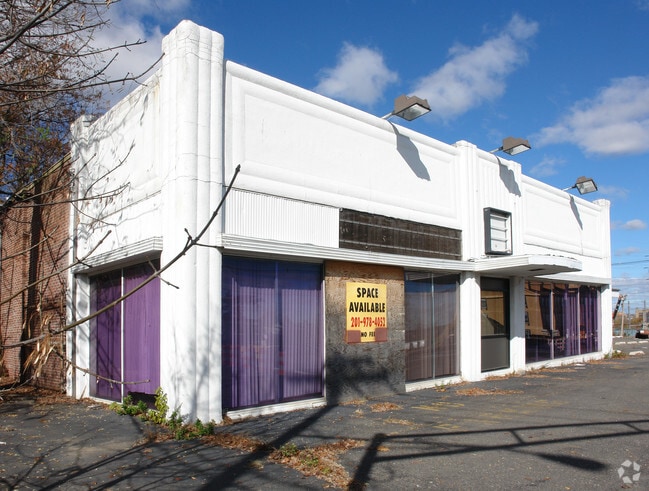
Property Record
160 Main St, South Amboy, NJ 08879

NEARBY LISTINGS FOR SALE OR LEASE
Property Detail
160 Main St
20-00116-0000-00011
1.729AC 11.01
Autorepair
Middlesex
X
New Jersey
34023C0156F
11
2024
1.73 AC
2025
South Edison
007402
Northern New Jersey
15,163 SF
New York-Jersey City-White Plains, NY-NJ
DEMOGRAPHICS near 160 Main St
1 Mile
3 Mile
5 Mile
2024 Total Population
10,576
102,901
209,337
2029 Population
10,477
100,729
206,423
Pop Growth 2024-2029
(0.94%)
(2.11%)
(1.39%)
Average Age
42
39
40
2024 Total Households
4,219
35,786
75,560
HH Growth 2024-2029
(0.97%)
(1.96%)
(1.34%)
Median Household Inc
$96,664
$74,835
$86,802
Avg Household Size
2.40
2.80
2.70
2024 Avg HH Vehicles
2.00
2.00
2.00
Median Home Value
$352,316
$367,692
$374,614
Median Year Built
1954
1964
1968
Nearby Places
Map Layers
Map Styles
 Street
 Aerial
- Restaurants
- Banks
- Shops
- Fitness
- Groceries
PUBLIC TRANSPORTATION
COMMUTER RAIL
South Amboy (North Jersey Coast Line - NJ Transit Commuter Rail (NJ Transit))
DRIVE
WALK
Distance
South Amboy (North Jersey Coast Line - NJ Transit Commuter Rail (NJ Transit))
3 min
6 min
0.3 mi
Perth Amboy (North Jersey Coast Line - NJ Transit Commuter Rail (NJ Transit))
DRIVE
WALK
Distance
Perth Amboy (North Jersey Coast Line - NJ Transit Commuter Rail (NJ Transit))
6 min
3.3 mi
AIRPORT
Newark Liberty International
DRIVE
WALK
Distance
Newark Liberty International
31 min
21.2 mi
LaGuardia
DRIVE
WALK
Distance
LaGuardia
60 min
38.6 mi
John F Kennedy International
DRIVE
WALK
Distance
John F Kennedy International
62 min
41.2 mi
Freight Ports
New York Container Terminal
DRIVE
WALK
Distance
New York Container Terminal
24 min
16.3 mi
Nearby Properties
Address
Land Use
TOTAL SIZE
Lot Size
Zoning
Address
Land Use
TOTAL SIZE
Lot Size
Zoning
1,889 SF
235.62 AC
Address
Land Use
TOTAL SIZE
Lot Size
Zoning
0.28 AC
CBD
Address
Land Use
TOTAL SIZE
Lot Size
Zoning
53.04 AC
S-1F
Address
Land Use
TOTAL SIZE
Lot Size
Zoning
10.69 AC
R-MM
Address
Land Use
TOTAL SIZE
Lot Size
Zoning
15.15 AC
RMMF
Address
Land Use
TOTAL SIZE
Lot Size
Zoning
Address
Land Use
TOTAL SIZE
Lot Size
Zoning
2.14 AC
C-4
Address
Land Use
TOTAL SIZE
Lot Size
Zoning
2.51 AC
H
Address
Land Use
TOTAL SIZE
Lot Size
Zoning
Address
Land Use
TOTAL SIZE
Lot Size
Zoning
6.79 AC
R-50
Address
Land Use
TOTAL SIZE
Lot Size
Zoning
7.23 AC
S-2A
Address
Land Use
TOTAL SIZE
Lot Size
Zoning
27.36 AC
Address
Land Use
TOTAL SIZE
Lot Size
Zoning
726 SF
75.46 AC
P
Address
Land Use
TOTAL SIZE
Lot Size
Zoning
6,822 SF
29.22 AC
S-2C
Address
Land Use
TOTAL SIZE
Lot Size
Zoning
7,904 SF
60 AC
AF
Address
Land Use
TOTAL SIZE
Lot Size
Zoning
Address
Land Use
TOTAL SIZE
Lot Size
Zoning
90.33 AC
Address
Land Use
TOTAL SIZE
Lot Size
Zoning
276 SF
6.59 AC
S-2A
Address
Land Use
TOTAL SIZE
Lot Size
Zoning
23.01 AC
S-1F
Address
Land Use
TOTAL SIZE
Lot Size
Zoning
31.22 AC
G1
Address
Land Use
TOTAL SIZE
Lot Size
Zoning
9.72 AC
M-1
Address
Land Use
TOTAL SIZE
Lot Size
Zoning
1.58 AC
Address
Land Use
TOTAL SIZE
Lot Size
Zoning
3.29 AC
M1
Address
Land Use
TOTAL SIZE
Lot Size
Zoning
14,270 SF
7.42 AC
R-MM
Address
Land Use
TOTAL SIZE
Lot Size
Zoning
8.90 AC
S-1A
Address
Land Use
TOTAL SIZE
Lot Size
Zoning
136,121 SF
12.84 AC
RB
Address
Land Use
TOTAL SIZE
Lot Size
Zoning
7,905 SF
26.55 AC
CC
Address
Land Use
TOTAL SIZE
Lot Size
Zoning
Address
Land Use
TOTAL SIZE
Lot Size
Zoning
6.19 AC
R-MM
Address
Land Use
TOTAL SIZE
Lot Size
Zoning
800 SF
30 AC
R-50
The World's #1 Commercial Real Estate Marketplace
Connect with us
© 2025 CoStar Group
The information above has been obtained from sources believed reliable. While we do not doubt its accuracy we have not verified it and make no guarantee, warranty or representation about it. It is your responsibility to independently confirm its accuracy and completeness. Any projections, opinions, assumptions, or estimates used are for example only and do not represent the current or future performance of the property. The value of this transaction to you depends on tax and other factors which should be evaluated by your tax, financial, and legal advisors. You and your advisors should conduct a careful, independent investigation of the property to determine to your satisfaction the suitability of the property for your needs.