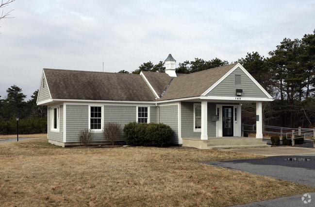
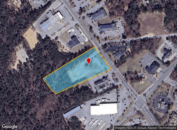
Property Record
160 Route 137, Harwich, MA 02645

NEARBY LISTINGS FOR SALE OR LEASE
-
-
View all Harwich listings for lease on LoopNet.com
Property Detail
160 Route 137
Officebuilding
Barnstable
X
Massachusetts
25001C0609J
3.39 AC
2025
Cape Cod
2025
Other Market Areas
011100
Barnstable Town, MA
1,964 SF
HARW M:86 P:M12-2
DEMOGRAPHICS near 160 Route 137
1 Mile
3 Mile
5 Mile
2024 Total Population
2,174
15,381
33,265
2029 Population
2,229
15,957
34,974
Pop Growth 2024-2029
+ 2.53%
+ 3.74%
+ 5.14%
Average Age
50
52
53
2024 Total Households
958
7,091
15,733
HH Growth 2024-2029
+ 2.40%
+ 3.69%
+ 5.19%
Median Household Inc
$90,010
$89,122
$89,558
Avg Household Size
2.20
2.10
2.00
2024 Avg HH Vehicles
2.00
2.00
2.00
Median Home Value
$610,955
$652,374
$673,309
Median Year Built
1976
1977
1978
Nearby Places
Map Layers
Map Styles
 Street
 Aerial
- Restaurants
- Banks
- Shops
- Fitness
- Groceries
PUBLIC TRANSPORTATION
AIRPORT
Nantucket Memorial
DRIVE
WALK
Distance
Nantucket Memorial
175 min
49.6 mi
Freight Ports
Port of New Bedford Harbor
DRIVE
WALK
Distance
Port of New Bedford Harbor
87 min
62.4 mi
SALE & LEASE HISTORY
LISTING DATE
SALE/LEASE

Jun 21, 2021
For Lease
Nearby Properties
Address
Land Use
TOTAL SIZE
Lot Size
Zoning
Address
Land Use
TOTAL SIZE
Lot Size
Zoning
49.58 AC
E
Address
Land Use
TOTAL SIZE
Lot Size
Zoning
10,884 SF
22.18 AC
R
Address
Land Use
TOTAL SIZE
Lot Size
Zoning
2,295.68 AC
RC
Address
Land Use
TOTAL SIZE
Lot Size
Zoning
129.50 AC
R40
Address
Land Use
TOTAL SIZE
Lot Size
Zoning
129,534 SF
31.75 AC
M
Address
Land Use
TOTAL SIZE
Lot Size
Zoning
66.01 AC
R40
Address
Land Use
TOTAL SIZE
Lot Size
Zoning
18.12 AC
R
Address
Land Use
TOTAL SIZE
Lot Size
Zoning
184.82 AC
E
Address
Land Use
TOTAL SIZE
Lot Size
Zoning
101.55 AC
M
Address
Land Use
TOTAL SIZE
Lot Size
Zoning
3,200 SF
142.32 AC
E
Address
Land Use
TOTAL SIZE
Lot Size
Zoning
65,651 SF
13.03 AC
RESD.
Address
Land Use
TOTAL SIZE
Lot Size
Zoning
72.55 AC
R60
Address
Land Use
TOTAL SIZE
Lot Size
Zoning
80 AC
M
Address
Land Use
TOTAL SIZE
Lot Size
Zoning
70,653 SF
12.61 AC
RESD.
Address
Land Use
TOTAL SIZE
Lot Size
Zoning
4.40 AC
R40
Address
Land Use
TOTAL SIZE
Lot Size
Zoning
10.19 AC
R30
Address
Land Use
TOTAL SIZE
Lot Size
Zoning
153.96 AC
E
Address
Land Use
TOTAL SIZE
Lot Size
Zoning
2,436 SF
2.18 AC
R40
Address
Land Use
TOTAL SIZE
Lot Size
Zoning
5.12 AC
M
Address
Land Use
TOTAL SIZE
Lot Size
Zoning
2,492 SF
167.50 AC
RESD.
Address
Land Use
TOTAL SIZE
Lot Size
Zoning
912 SF
1.07 AC
R40
Address
Land Use
TOTAL SIZE
Lot Size
Zoning
Address
Land Use
TOTAL SIZE
Lot Size
Zoning
5,933 SF
1.90 AC
R
Address
Land Use
TOTAL SIZE
Lot Size
Zoning
72 AC
MC
Address
Land Use
TOTAL SIZE
Lot Size
Zoning
5,342 SF
2.50 AC
R
Address
Land Use
TOTAL SIZE
Lot Size
Zoning
53,410 SF
5.85 AC
E
Address
Land Use
TOTAL SIZE
Lot Size
Zoning
46,579 SF
4.58 AC
R
Address
Land Use
TOTAL SIZE
Lot Size
Zoning
3.61 AC
R
Address
Land Use
TOTAL SIZE
Lot Size
Zoning
3.59 AC
R40
Address
Land Use
TOTAL SIZE
Lot Size
Zoning
2.50 AC
R40
The World's #1 Commercial Real Estate Marketplace
Connect with us
© 2026 CoStar Group
The information above has been obtained from sources believed reliable. While we do not doubt its accuracy we have not verified it and make no guarantee, warranty or representation about it. It is your responsibility to independently confirm its accuracy and completeness. Any projections, opinions, assumptions, or estimates used are for example only and do not represent the current or future performance of the property. The value of this transaction to you depends on tax and other factors which should be evaluated by your tax, financial, and legal advisors. You and your advisors should conduct a careful, independent investigation of the property to determine to your satisfaction the suitability of the property for your needs.