Property Record
160 Visger Rd, River Rouge, MI 48218
NEARBY LISTINGS FOR SALE OR LEASE
Property Detail
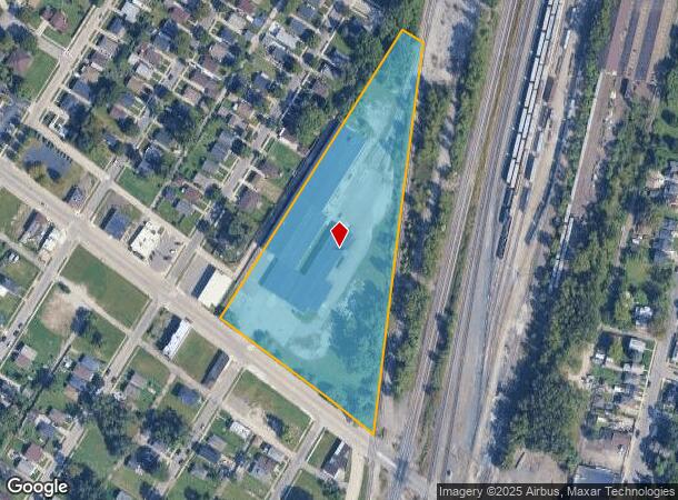
160 Visger Rd
Detroit-Warren-Dearborn, MI
River Rouge
50-010-99-0001-000
114S T U V PT OF PC 114 BEG AT SE COR LOT 108 RIVER ROUGE URBAN RENEWAL PLAT NO 1 L9 P10 WCR TH N29DEG 39M E 893.95FT TH S60DEG 21M 00S E 63.83FT TH S4DEG 40M 00S W 1032.89FT TH N55DEG 31M 00S W 501.87FT TO POB 5.82 AC
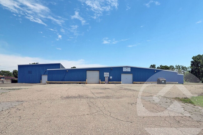
Warehouse
Wayne
X
Michigan
26163C0269F
108
2024
5.82 AC
2025
Downriver North
579300
Detroit
56,025 SF
DEMOGRAPHICS near 160 Visger Rd
1 Mile
3 Mile
5 Mile
2024 Total Population
16,317
78,814
207,767
2029 Population
16,105
76,329
200,272
Pop Growth 2024-2029
(1.30%)
(3.15%)
(3.61%)
Average Age
38
38
38
2024 Total Households
6,378
29,996
78,539
HH Growth 2024-2029
(1.41%)
(3.18%)
(3.64%)
Median Household Inc
$37,244
$45,797
$51,885
Avg Household Size
2.50
2.60
2.60
2024 Avg HH Vehicles
1.00
2.00
2.00
Median Home Value
$63,129
$98,905
$132,750
Median Year Built
1951
1952
1952
Nearby Places
Map Layers
Map Styles
 Street
 Aerial
- Restaurants
- Banks
- Shops
- Fitness
- Groceries
PUBLIC TRANSPORTATION
COMMUTER RAIL
Dearborn (Wolverine - Amtrak)
DRIVE
WALK
Distance
Dearborn (Wolverine - Amtrak)
19 min
7.8 mi
AIRPORT
Detroit Metro Wayne County
DRIVE
WALK
Distance
Detroit Metro Wayne County
26 min
16.0 mi
Windsor International
DRIVE
WALK
Distance
Windsor International
35 min
17.9 mi
Freight Ports
Port of Toledo
DRIVE
WALK
Distance
Port of Toledo
69 min
53.8 mi
SALE & LEASE HISTORY
LISTING DATE
SALE/LEASE

Jun 13, 2024
For Lease
Nearby Properties
Address
Land Use
TOTAL SIZE
Lot Size
Zoning
Address
Land Use
TOTAL SIZE
Lot Size
Zoning
590,116 SF
388.80 AC
ID
Address
Land Use
TOTAL SIZE
Lot Size
Zoning
1,025,154 SF
233.15 AC
Address
Land Use
TOTAL SIZE
Lot Size
Zoning
7,320 SF
226.49 AC
Address
Land Use
TOTAL SIZE
Lot Size
Zoning
114,157 SF
Address
Land Use
TOTAL SIZE
Lot Size
Zoning
196,801 SF
38.32 AC
M5
Address
Land Use
TOTAL SIZE
Lot Size
Zoning
111,402 SF
3.17 AC
Address
Land Use
TOTAL SIZE
Lot Size
Zoning
193,155 SF
8.68 AC
R1 1 FA
Address
Land Use
TOTAL SIZE
Lot Size
Zoning
145,572 SF
58.41 AC
M4
Address
Land Use
TOTAL SIZE
Lot Size
Zoning
76,350 SF
0.69 AC
Address
Land Use
TOTAL SIZE
Lot Size
Zoning
79.03 AC
M2 HEAV
Address
Land Use
TOTAL SIZE
Lot Size
Zoning
351,906 SF
42.21 AC
M4
Address
Land Use
TOTAL SIZE
Lot Size
Zoning
897,317 SF
34.53 AC
ID
Address
Land Use
TOTAL SIZE
Lot Size
Zoning
90,005 SF
611 AC
BLL
Address
Land Use
TOTAL SIZE
Lot Size
Zoning
660 SF
41.97 AC
R1 1 FA
Address
Land Use
TOTAL SIZE
Lot Size
Zoning
105,920 SF
12.46 AC
Address
Land Use
TOTAL SIZE
Lot Size
Zoning
45,400 SF
R1 1 FA
Address
Land Use
TOTAL SIZE
Lot Size
Zoning
32,245 SF
23.27 AC
M5
Address
Land Use
TOTAL SIZE
Lot Size
Zoning
105,503 SF
19.83 AC
Address
Land Use
TOTAL SIZE
Lot Size
Zoning
95,679 SF
27.44 AC
M4
Address
Land Use
TOTAL SIZE
Lot Size
Zoning
77,026 SF
9.64 AC
R1 1 FA
Address
Land Use
TOTAL SIZE
Lot Size
Zoning
106.97 AC
M2 HEAV
Address
Land Use
TOTAL SIZE
Lot Size
Zoning
47,778 SF
27.12 AC
R1 1 FA
Address
Land Use
TOTAL SIZE
Lot Size
Zoning
3,430 SF
79.54 AC
M2 HEAV
Address
Land Use
TOTAL SIZE
Lot Size
Zoning
228,000 SF
12.70 AC
Address
Land Use
TOTAL SIZE
Lot Size
Zoning
414,868 SF
26.36 AC
R1 1 FA
Address
Land Use
TOTAL SIZE
Lot Size
Zoning
8,774 SF
29.39 AC
R1 1 FA
Address
Land Use
TOTAL SIZE
Lot Size
Zoning
2,220 SF
10.66 AC
Address
Land Use
TOTAL SIZE
Lot Size
Zoning
108,000 SF
7.46 AC
Address
Land Use
TOTAL SIZE
Lot Size
Zoning
292,797 SF
9.31 AC
Address
Land Use
TOTAL SIZE
Lot Size
Zoning
77,520 SF
6.52 AC
IC
The World's #1 Commercial Real Estate Marketplace
Connect with us
© 2025 CoStar Group
The information above has been obtained from sources believed reliable. While we do not doubt its accuracy we have not verified it and make no guarantee, warranty or representation about it. It is your responsibility to independently confirm its accuracy and completeness. Any projections, opinions, assumptions, or estimates used are for example only and do not represent the current or future performance of the property. The value of this transaction to you depends on tax and other factors which should be evaluated by your tax, financial, and legal advisors. You and your advisors should conduct a careful, independent investigation of the property to determine to your satisfaction the suitability of the property for your needs.