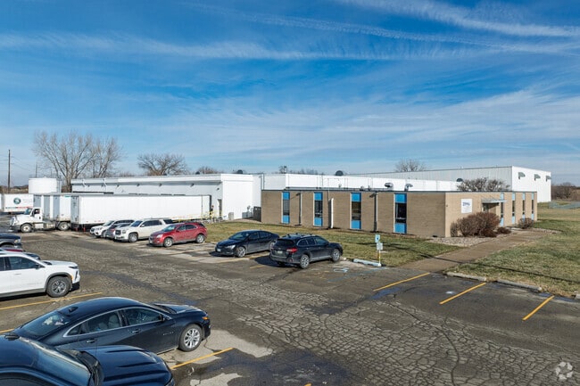
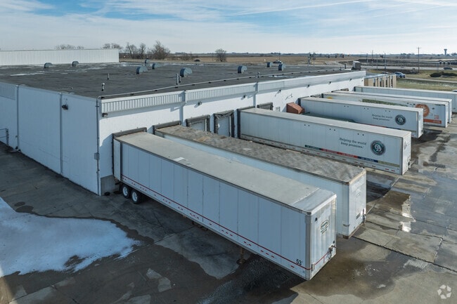
Property Record
1600 2Nd St Ne, Bondurant, IA 50035


NEARBY LISTINGS FOR SALE OR LEASE
Property Detail
1600 2Nd St Ne
231-00021001000
Sec 29-80-22
Officebuilding
BEG 33F E & 40F N OF SW COR THN N 456.4F NELY 1007.08F S 102.15F SWLY787.8F W439.79F TO POB S 1/2 SW 1/4 LESS RD SEC 29-80-22
X
Polk
19153C0230F
Iowa
2024
9.02 AC
2025
Northeast
010102
Des Moines
97,841 SF
Des Moines-West Des Moines, IA
DEMOGRAPHICS near 1600 2Nd St Ne
1 Mile
3 Mile
5 Mile
2024 Total Population
2,933
9,721
27,196
2029 Population
3,100
10,386
28,651
Pop Growth 2024-2029
+ 5.69%
+ 6.84%
+ 5.35%
Average Age
33
33
37
2024 Total Households
988
3,098
9,778
HH Growth 2024-2029
+ 5.87%
+ 6.91%
+ 5.33%
Median Household Inc
$103,409
$111,674
$92,746
Avg Household Size
3.00
3.10
2.70
2024 Avg HH Vehicles
2.00
2.00
2.00
Median Home Value
$265,180
$281,086
$259,513
Median Year Built
2010
2010
1999
Nearby Places
Map Layers
Map Styles
 Street
 Aerial
- Restaurants
- Banks
- Shops
- Fitness
- Groceries
PUBLIC TRANSPORTATION
AIRPORT
Des Moines International
DRIVE
WALK
Distance
Des Moines International
32 min
19.8 mi
Freight Ports
Port Milwaukee
DRIVE
WALK
Distance
Port Milwaukee
405 min
365.0 mi
Nearby Properties
Address
Land Use
TOTAL SIZE
Lot Size
Zoning
Address
Land Use
TOTAL SIZE
Lot Size
Zoning
2,693,534 SF
167.13 AC
Address
Land Use
TOTAL SIZE
Lot Size
Zoning
279,650 SF
48.24 AC
Address
Land Use
TOTAL SIZE
Lot Size
Zoning
325,160 SF
17.24 AC
Address
Land Use
TOTAL SIZE
Lot Size
Zoning
265,726 SF
14.76 AC
Address
Land Use
TOTAL SIZE
Lot Size
Zoning
106,824 SF
4.50 AC
Address
Land Use
TOTAL SIZE
Lot Size
Zoning
78,180 SF
7.31 AC
Address
Land Use
TOTAL SIZE
Lot Size
Zoning
49,145 SF
6.06 AC
Address
Land Use
TOTAL SIZE
Lot Size
Zoning
134,400 SF
6.01 AC
M-1
Address
Land Use
TOTAL SIZE
Lot Size
Zoning
27,908 SF
14.43 AC
Address
Land Use
TOTAL SIZE
Lot Size
Zoning
72,024 SF
30 AC
Address
Land Use
TOTAL SIZE
Lot Size
Zoning
29,000 SF
6.36 AC
M-1
Address
Land Use
TOTAL SIZE
Lot Size
Zoning
38,997 SF
5.86 AC
R-3
Address
Land Use
TOTAL SIZE
Lot Size
Zoning
34,960 SF
14.09 AC
Address
Land Use
TOTAL SIZE
Lot Size
Zoning
60,321 SF
3.29 AC
C-2
Address
Land Use
TOTAL SIZE
Lot Size
Zoning
5,402 SF
15.09 AC
Address
Land Use
TOTAL SIZE
Lot Size
Zoning
34,122 SF
8.08 AC
M-1
Address
Land Use
TOTAL SIZE
Lot Size
Zoning
22,000 SF
8.52 AC
Address
Land Use
TOTAL SIZE
Lot Size
Zoning
45,372 SF
3.21 AC
C-2
Address
Land Use
TOTAL SIZE
Lot Size
Zoning
12,798 SF
1.74 AC
Address
Land Use
TOTAL SIZE
Lot Size
Zoning
22,398 SF
3.02 AC
Address
Land Use
TOTAL SIZE
Lot Size
Zoning
7,500 SF
8.99 AC
Address
Land Use
TOTAL SIZE
Lot Size
Zoning
5,650 SF
2.65 AC
Address
Land Use
TOTAL SIZE
Lot Size
Zoning
67,200 SF
7.97 AC
C-2
Address
Land Use
TOTAL SIZE
Lot Size
Zoning
26,331 SF
5.36 AC
C2
Address
Land Use
TOTAL SIZE
Lot Size
Zoning
24,034 SF
3.61 AC
C-2
Address
Land Use
TOTAL SIZE
Lot Size
Zoning
25,280 SF
0.60 AC
R-3
Address
Land Use
TOTAL SIZE
Lot Size
Zoning
40,000 SF
2.96 AC
C-2
Address
Land Use
TOTAL SIZE
Lot Size
Zoning
20,000 SF
10 AC
The World's #1 Commercial Real Estate Marketplace
Connect with us
© 2026 CoStar Group
The information above has been obtained from sources believed reliable. While we do not doubt its accuracy we have not verified it and make no guarantee, warranty or representation about it. It is your responsibility to independently confirm its accuracy and completeness. Any projections, opinions, assumptions, or estimates used are for example only and do not represent the current or future performance of the property. The value of this transaction to you depends on tax and other factors which should be evaluated by your tax, financial, and legal advisors. You and your advisors should conduct a careful, independent investigation of the property to determine to your satisfaction the suitability of the property for your needs.