Property Record
1600 Bunton Creek Rd, Kyle, TX 78640
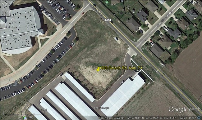

Property Detail
1600 Bunton Creek Rd
Austin-Round Rock-San Marcos, TX
BROD SUBDIVISION, LOT 1, ACRES 0.9868
R135915
HAYS
Residentialacreage
Texas
B and X Area of moderate flood hazard, usually the area between the limits of the 100-year and 500-year floods.
1
2024
0.99 AC
2025
Hays County
010916
Austin
NEARBY LISTINGS FOR SALE OR LEASE
DEMOGRAPHICS near 1600 Bunton Creek Rd
1 mile
3 mile
5 mile
2024 Total Population
6,279
63,740
97,821
2029 Population
8,359
84,023
128,970
Pop Growth 2024-2029
+ 33.13%
+ 31.82%
+ 31.84%
Average Age
34
34
35
2024 Total Households
2,068
21,126
32,261
HH Growth 2024-2029
+ 34.04%
+ 32.86%
+ 32.92%
Median Household Inc
$93,038
$86,132
$87,710
Avg Household Size
3.10
3.00
3.00
2024 Avg HH Vehicles
2.00
2.00
2.00
Median Home Value
$206,233
$249,062
$262,698
Median Year Built
2009
2009
2010
Nearby Places
Map Layers
Map Styles
 Street
 Aerial
Transit
 Traffic
 Biking
Places
Listings with unknown addresses are not visible on the map
- Restaurants
- Banks
- Shops
- Fitness
- Groceries
PUBLIC TRANSPORTATION
AIRPORT
Austin-Bergstrom International
Drive
Walk
Distance
Austin-Bergstrom International
28 min
26.5 mi
Freight Ports
Calhoun Port
Drive
Walk
Distance
Calhoun Port
1 min
119.9 mi
SALE & LEASE HISTORY
LISTING DATE
SALE/LEASE

Sep 24, 2016
For Sale
May 23, 2022
For Sale
Jan 25, 2024
For Sale
Dec 18, 2019
For Sale
Nearby Properties
Address
Land Use
TOTAL SIZE
Lot Size
Zoning
Address
Land Use
TOTAL SIZE
Lot Size
Zoning
331,761 SF
57.23 AC
Address
Land Use
TOTAL SIZE
Lot Size
Zoning
364,569 SF
14.36 AC
Address
Land Use
TOTAL SIZE
Lot Size
Zoning
301,466 SF
21 AC
Address
Land Use
TOTAL SIZE
Lot Size
Zoning
319,545 SF
13.74 AC
Address
Land Use
TOTAL SIZE
Lot Size
Zoning
301,745 SF
16.14 AC
Address
Land Use
TOTAL SIZE
Lot Size
Zoning
201,966 SF
33.54 AC
Address
Land Use
TOTAL SIZE
Lot Size
Zoning
332,150 SF
7.08 AC
Address
Land Use
TOTAL SIZE
Lot Size
Zoning
233,088 SF
12.36 AC
Address
Land Use
TOTAL SIZE
Lot Size
Zoning
421,200 SF
14.39 AC
Address
Land Use
TOTAL SIZE
Lot Size
Zoning
491,520 SF
38.84 AC
Address
Land Use
TOTAL SIZE
Lot Size
Zoning
383,970 SF
17.76 AC
Address
Land Use
TOTAL SIZE
Lot Size
Zoning
230,002 SF
6.07 AC
Address
Land Use
TOTAL SIZE
Lot Size
Zoning
403,635 SF
24.01 AC
Address
Land Use
TOTAL SIZE
Lot Size
Zoning
240,002 SF
53.46 AC
Address
Land Use
TOTAL SIZE
Lot Size
Zoning
158,169 SF
14 AC
Address
Land Use
TOTAL SIZE
Lot Size
Zoning
240,168 SF
9.45 AC
Address
Land Use
TOTAL SIZE
Lot Size
Zoning
234,794 SF
10.07 AC
Address
Land Use
TOTAL SIZE
Lot Size
Zoning
193,470 SF
7.42 AC
Address
Land Use
TOTAL SIZE
Lot Size
Zoning
78,088 SF
7 AC
Address
Land Use
TOTAL SIZE
Lot Size
Zoning
144,088 SF
7.63 AC
Address
Land Use
TOTAL SIZE
Lot Size
Zoning
64,836 SF
10 AC
Address
Land Use
TOTAL SIZE
Lot Size
Zoning
258,960 SF
18.31 AC
Address
Land Use
TOTAL SIZE
Lot Size
Zoning
62,202 SF
5.14 AC
Address
Land Use
TOTAL SIZE
Lot Size
Zoning
96.18 AC
Address
Land Use
TOTAL SIZE
Lot Size
Zoning
308,550 SF
25.67 AC
Address
Land Use
TOTAL SIZE
Lot Size
Zoning
73,518 SF
12.79 AC
Address
Land Use
TOTAL SIZE
Lot Size
Zoning
151,769 SF
21.20 AC
Address
Land Use
TOTAL SIZE
Lot Size
Zoning
133,502 SF
4.24 AC
Address
Land Use
TOTAL SIZE
Lot Size
Zoning
156,634 SF
3.89 AC
Address
Land Use
TOTAL SIZE
Lot Size
Zoning
175,604 SF
11.72 AC
The World's #1 Commercial Real Estate Marketplace
Connect with us
© 2026 CoStar Group
The information above has been obtained from sources believed reliable. While we do not doubt its accuracy we have not verified it and make no guarantee, warranty or representation about it. It is your responsibility to independently confirm its accuracy and completeness. Any projections, opinions, assumptions, or estimates used are for example only and do not represent the current or future performance of the property. The value of this transaction to you depends on tax and other factors which should be evaluated by your tax, financial, and legal advisors. You and your advisors should conduct a careful, independent investigation of the property to determine to your satisfaction the suitability of the property for your needs.