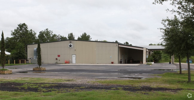
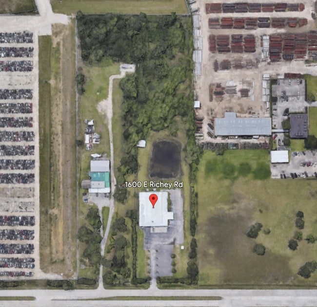
Property Record
1600 E Richey Rd, Houston, TX 77073

Property Detail
1600 E Richey Rd
1269980010001
RES A BLK 1 E RICHEY GARDENS
Outdoorrecreationbeachmountaindesert
HARRIS
B and X Area of moderate flood hazard, usually the area between the limits of the 100-year and 500-year floods.
Texas
2025
4.47 AC
2025
Greenspoint/IAH
240400
Houston
10,824 SF
Houston-Pasadena-The Woodlands, TX
NEARBY LISTINGS FOR SALE OR LEASE
-
-
View all Houston listings for lease on LoopNet.com
DEMOGRAPHICS near 1600 E Richey Rd
1 mile
3 mile
5 mile
2025 Total Population
1,309
54,681
228,242
2030 Population
1,378
57,981
244,181
Pop Growth 2025-2030
+ 5.27%
+ 6.04%
+ 6.98%
Average Age
38
33
34
2025 Total Households
399
16,612
77,609
HH Growth 2025-2030
+ 5.51%
+ 6.34%
+ 7.26%
Median Household Inc
$72,187
$70,143
$57,773
Avg Household Size
3.20
3.20
2.90
2025 Avg HH Vehicles
2.00
2.00
2.00
Median Home Value
$251,422
$224,500
$234,799
Median Year Built
2000
2003
1992
Nearby Places
Map Layers
Map Styles
 Street
 Aerial
Layers
 Traffic
 Biking
Places
Listings with unknown addresses are not visible on the map
- Restaurants
- Banks
- Shops
- Fitness
- Groceries
PUBLIC TRANSPORTATION
AIRPORT
George Bush Intcntl/Houston
Drive
Walk
Distance
George Bush Intcntl/Houston
13 min
9.3 mi
William P Hobby
Drive
Walk
Distance
William P Hobby
47 min
31.1 mi
Freight Ports
Port of Houston
Drive
Walk
Distance
Port of Houston
35 min
25.0 mi
SALE & LEASE HISTORY
LISTING DATE
SALE/LEASE

Sep 24, 2016
For Sale
Dec 05, 2023
For Lease
Apr 13, 2023
For Sale
Nearby Properties
Address
Land Use
TOTAL SIZE
Lot Size
Zoning
Address
Land Use
TOTAL SIZE
Lot Size
Zoning
764,495 SF
54.15 AC
Address
Land Use
TOTAL SIZE
Lot Size
Zoning
657,500 SF
36.24 AC
Address
Land Use
TOTAL SIZE
Lot Size
Zoning
502,325 SF
25.13 AC
Address
Land Use
TOTAL SIZE
Lot Size
Zoning
485,125 SF
28.55 AC
Address
Land Use
TOTAL SIZE
Lot Size
Zoning
276,324 SF
33.79 AC
Address
Land Use
TOTAL SIZE
Lot Size
Zoning
409,480 SF
27.32 AC
Address
Land Use
TOTAL SIZE
Lot Size
Zoning
417,597 SF
16.98 AC
Address
Land Use
TOTAL SIZE
Lot Size
Zoning
350,423 SF
122.83 AC
Address
Land Use
TOTAL SIZE
Lot Size
Zoning
394,784 SF
22.47 AC
Address
Land Use
TOTAL SIZE
Lot Size
Zoning
362,720 SF
20.23 AC
Address
Land Use
TOTAL SIZE
Lot Size
Zoning
280,283 SF
16.56 AC
Address
Land Use
TOTAL SIZE
Lot Size
Zoning
356,622 SF
18.26 AC
Address
Land Use
TOTAL SIZE
Lot Size
Zoning
291,656 SF
18.94 AC
Address
Land Use
TOTAL SIZE
Lot Size
Zoning
435,650 SF
Address
Land Use
TOTAL SIZE
Lot Size
Zoning
271,432 SF
35.81 AC
Address
Land Use
TOTAL SIZE
Lot Size
Zoning
329,643 SF
19.99 AC
Address
Land Use
TOTAL SIZE
Lot Size
Zoning
57,551 SF
49.71 AC
Address
Land Use
TOTAL SIZE
Lot Size
Zoning
318,000 SF
18.53 AC
Address
Land Use
TOTAL SIZE
Lot Size
Zoning
287,251 SF
18.12 AC
Address
Land Use
TOTAL SIZE
Lot Size
Zoning
257,000 SF
13.34 AC
Address
Land Use
TOTAL SIZE
Lot Size
Zoning
288,525 SF
17.66 AC
Address
Land Use
TOTAL SIZE
Lot Size
Zoning
597,462 SF
42.07 AC
Address
Land Use
TOTAL SIZE
Lot Size
Zoning
267,158 SF
12.96 AC
Address
Land Use
TOTAL SIZE
Lot Size
Zoning
239,270 SF
13.39 AC
Address
Land Use
TOTAL SIZE
Lot Size
Zoning
204,870 SF
13.40 AC
Address
Land Use
TOTAL SIZE
Lot Size
Zoning
194,646 SF
10.85 AC
Address
Land Use
TOTAL SIZE
Lot Size
Zoning
203,013 SF
12.28 AC
Address
Land Use
TOTAL SIZE
Lot Size
Zoning
Address
Land Use
TOTAL SIZE
Lot Size
Zoning
181,200 SF
11.07 AC
Address
Land Use
TOTAL SIZE
Lot Size
Zoning
269,308 SF
10.28 AC
The World's #1 Commercial Real Estate Marketplace
Connect with us
© 2026 CoStar Group
The information above has been obtained from sources believed reliable. While we do not doubt its accuracy we have not verified it and make no guarantee, warranty or representation about it. It is your responsibility to independently confirm its accuracy and completeness. Any projections, opinions, assumptions, or estimates used are for example only and do not represent the current or future performance of the property. The value of this transaction to you depends on tax and other factors which should be evaluated by your tax, financial, and legal advisors. You and your advisors should conduct a careful, independent investigation of the property to determine to your satisfaction the suitability of the property for your needs.