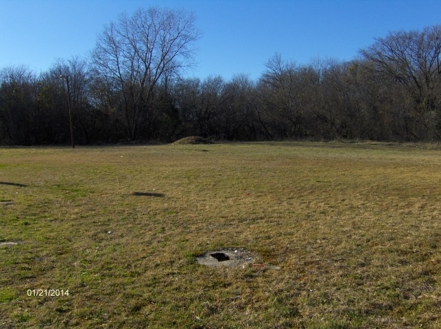
Property Record
1600 Gholson Rd, Waco, TX 76704

Property Detail
1600 Gholson Rd
48-026701-053300-3
TOMAS DE LA VEGA ACRES 29.651
Commercialacreage
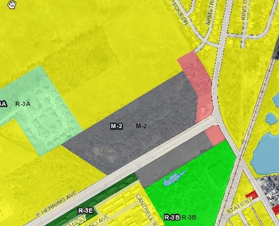
MCLENNAN
M-2,
Texas
AE The base floodplain where base flood elevations are provided. AE Zones are now used on new format FIRMs instead of A1-A30 Zones.
29.65 AC
2024
Waco
2025
Other Market Areas
001402
Waco, TX
NEARBY LISTINGS FOR SALE OR LEASE
DEMOGRAPHICS near 1600 Gholson Rd
1 mile
3 mile
5 mile
2025 Total Population
5,517
47,357
117,946
2030 Population
5,740
49,244
122,245
Pop Growth 2025-2030
+ 4.04%
+ 3.98%
+ 3.64%
Average Age
36
34
35
2025 Total Households
2,125
16,325
43,038
HH Growth 2025-2030
+ 4.09%
+ 4.41%
+ 3.77%
Median Household Inc
$28,928
$39,926
$43,728
Avg Household Size
2.40
2.50
2.50
2025 Avg HH Vehicles
1.00
2.00
2.00
Median Home Value
$143,501
$156,426
$175,359
Median Year Built
1972
1974
1973
Nearby Places
Map Layers
Map Styles
 Street
 Aerial
Layers
 Traffic
 Biking
Places
Listings with unknown addresses are not visible on the map
- Restaurants
- Banks
- Shops
- Fitness
- Groceries
PUBLIC TRANSPORTATION
AIRPORT
Waco Regional
Drive
Walk
Distance
Waco Regional
19 min
8.7 mi
SALE & LEASE HISTORY
LISTING DATE
SALE/LEASE

Sep 24, 2016
For Sale
Nearby Properties
Address
Land Use
TOTAL SIZE
Lot Size
Zoning
Address
Land Use
TOTAL SIZE
Lot Size
Zoning
93.17 AC
2007 TIF
Address
Land Use
TOTAL SIZE
Lot Size
Zoning
549,274 SF
34.05 AC
O2
Address
Land Use
TOTAL SIZE
Lot Size
Zoning
120,623 SF
55.15 AC
2007 TIF
Address
Land Use
TOTAL SIZE
Lot Size
Zoning
394,674 SF
21.31 AC
O2
Address
Land Use
TOTAL SIZE
Lot Size
Zoning
27.28 AC
C
Address
Land Use
TOTAL SIZE
Lot Size
Zoning
24.75 AC
O2
Address
Land Use
TOTAL SIZE
Lot Size
Zoning
213,814 SF
7.05 AC
2007 TIF
Address
Land Use
TOTAL SIZE
Lot Size
Zoning
69,809 SF
8.12 AC
2007 TIF
Address
Land Use
TOTAL SIZE
Lot Size
Zoning
126,592 SF
5.05 AC
2007 TIF
Address
Land Use
TOTAL SIZE
Lot Size
Zoning
188,746 SF
1.14 AC
O2
Address
Land Use
TOTAL SIZE
Lot Size
Zoning
188,465 SF
5.85 AC
2007 TIF
Address
Land Use
TOTAL SIZE
Lot Size
Zoning
Address
Land Use
TOTAL SIZE
Lot Size
Zoning
193,780 SF
14.12 AC
C
Address
Land Use
TOTAL SIZE
Lot Size
Zoning
107,925 SF
2.20 AC
2007TIF
Address
Land Use
TOTAL SIZE
Lot Size
Zoning
16.78 AC
2007 TIF
Address
Land Use
TOTAL SIZE
Lot Size
Zoning
77,089 SF
5.09 AC
O2
Address
Land Use
TOTAL SIZE
Lot Size
Zoning
155,900 SF
2.85 AC
O2
Address
Land Use
TOTAL SIZE
Lot Size
Zoning
30.89 AC
R1
Address
Land Use
TOTAL SIZE
Lot Size
Zoning
206,113 SF
7.33 AC
2007TIF
Address
Land Use
TOTAL SIZE
Lot Size
Zoning
189,996 SF
13.98 AC
O2
Address
Land Use
TOTAL SIZE
Lot Size
Zoning
33,442 SF
2.80 AC
Address
Land Use
TOTAL SIZE
Lot Size
Zoning
21.14 AC
2007 TIF
Address
Land Use
TOTAL SIZE
Lot Size
Zoning
5.57 AC
2007 TIF
Address
Land Use
TOTAL SIZE
Lot Size
Zoning
84,139 SF
2.81 AC
2007 TIF
Address
Land Use
TOTAL SIZE
Lot Size
Zoning
124,525 SF
4.17 AC
O2
Address
Land Use
TOTAL SIZE
Lot Size
Zoning
117,646 SF
3.88 AC
2007 TIF
Address
Land Use
TOTAL SIZE
Lot Size
Zoning
51,175 SF
9.48 AC
2007 TIF
Address
Land Use
TOTAL SIZE
Lot Size
Zoning
186,588 SF
10.28 AC
C1
Address
Land Use
TOTAL SIZE
Lot Size
Zoning
74,664 SF
3.55 AC
2007 TIF
Address
Land Use
TOTAL SIZE
Lot Size
Zoning
21.76 AC
R
The World's #1 Commercial Real Estate Marketplace
Connect with us
© 2026 CoStar Group
The information above has been obtained from sources believed reliable. While we do not doubt its accuracy we have not verified it and make no guarantee, warranty or representation about it. It is your responsibility to independently confirm its accuracy and completeness. Any projections, opinions, assumptions, or estimates used are for example only and do not represent the current or future performance of the property. The value of this transaction to you depends on tax and other factors which should be evaluated by your tax, financial, and legal advisors. You and your advisors should conduct a careful, independent investigation of the property to determine to your satisfaction the suitability of the property for your needs.