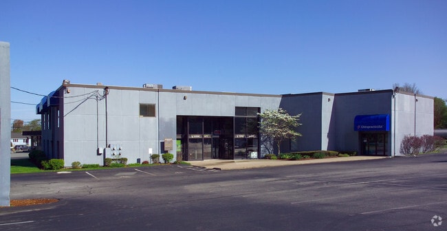
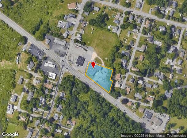
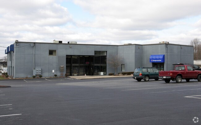
Property Record
1600 Grand Army Hwy, Somerset, MA 02726

NEARBY LISTINGS FOR SALE OR LEASE
Property Detail
1600 Grand Army Hwy
SOME-000008B-000000-000003
Bristol
Storebuilding
Massachusetts
X
3
25005C0331G
1.01 AC
2025
Attleboro/New Bedford
2025
Boston
644200
Providence-Warwick, RI-MA
14,244 SF
DEMOGRAPHICS near 1600 Grand Army Hwy
1 Mile
3 Mile
5 Mile
2024 Total Population
4,600
54,465
143,039
2029 Population
4,549
54,295
142,238
Pop Growth 2024-2029
(1.11%)
(0.31%)
(0.56%)
Average Age
44
43
41
2024 Total Households
1,843
23,113
60,617
HH Growth 2024-2029
(1.14%)
(0.31%)
(0.59%)
Median Household Inc
$95,851
$66,854
$61,464
Avg Household Size
2.50
2.30
2.30
2024 Avg HH Vehicles
2.00
2.00
2.00
Median Home Value
$360,231
$369,532
$365,462
Median Year Built
1960
1954
1953
Nearby Places
Map Layers
Map Styles
 Street
 Aerial
- Restaurants
- Banks
- Shops
- Fitness
- Groceries
PUBLIC TRANSPORTATION
AIRPORT
Rhode Island Tf Green International
DRIVE
WALK
Distance
Rhode Island Tf Green International
34 min
21.0 mi
Freight Ports
Port of New Bedford Harbor
DRIVE
WALK
Distance
Port of New Bedford Harbor
25 min
17.8 mi
SALE & LEASE HISTORY
LISTING DATE
SALE/LEASE

Sep 24, 2016
For Sale
Nearby Properties
Address
Land Use
TOTAL SIZE
Lot Size
Zoning
Address
Land Use
TOTAL SIZE
Lot Size
Zoning
226,473 SF
29.10 AC
R1
Address
Land Use
TOTAL SIZE
Lot Size
Zoning
203,989 SF
2.01 AC
A-2
Address
Land Use
TOTAL SIZE
Lot Size
Zoning
14.30 AC
G
Address
Land Use
TOTAL SIZE
Lot Size
Zoning
105,949 SF
25.21 AC
R1
Address
Land Use
TOTAL SIZE
Lot Size
Zoning
10 AC
B
Address
Land Use
TOTAL SIZE
Lot Size
Zoning
126,146 SF
1.18 AC
A-2
Address
Land Use
TOTAL SIZE
Lot Size
Zoning
255,600 SF
12.46 AC
R4
Address
Land Use
TOTAL SIZE
Lot Size
Zoning
177,051 SF
3.13 AC
CBD
Address
Land Use
TOTAL SIZE
Lot Size
Zoning
160,234 SF
2.98 AC
CBD
Address
Land Use
TOTAL SIZE
Lot Size
Zoning
75,736 SF
1.39 AC
B-L
Address
Land Use
TOTAL SIZE
Lot Size
Zoning
3,150 SF
7.91 AC
S
Address
Land Use
TOTAL SIZE
Lot Size
Zoning
155,364 SF
15.27 AC
C
Address
Land Use
TOTAL SIZE
Lot Size
Zoning
119,932 SF
4.79 AC
G
Address
Land Use
TOTAL SIZE
Lot Size
Zoning
136,814 SF
4.07 AC
IND
Address
Land Use
TOTAL SIZE
Lot Size
Zoning
143,084 SF
12.60 AC
R1
Address
Land Use
TOTAL SIZE
Lot Size
Zoning
152,620 SF
20.73 AC
C
Address
Land Use
TOTAL SIZE
Lot Size
Zoning
112,515 SF
1.83 AC
CBD
Address
Land Use
TOTAL SIZE
Lot Size
Zoning
137,976 SF
10.59 AC
C
Address
Land Use
TOTAL SIZE
Lot Size
Zoning
114,424 SF
12.94 AC
C
Address
Land Use
TOTAL SIZE
Lot Size
Zoning
6.48 AC
G
Address
Land Use
TOTAL SIZE
Lot Size
Zoning
4 AC
M
Address
Land Use
TOTAL SIZE
Lot Size
Zoning
106,293 SF
1.32 AC
CBD
Address
Land Use
TOTAL SIZE
Lot Size
Zoning
5.79 AC
S
Address
Land Use
TOTAL SIZE
Lot Size
Zoning
70,741 SF
16.24 AC
Address
Land Use
TOTAL SIZE
Lot Size
Zoning
103,846 SF
3.60 AC
G
Address
Land Use
TOTAL SIZE
Lot Size
Zoning
17.01 AC
S
Address
Land Use
TOTAL SIZE
Lot Size
Zoning
41,344 SF
1.18 AC
A-2
Address
Land Use
TOTAL SIZE
Lot Size
Zoning
24,480 SF
4.69 AC
C
Address
Land Use
TOTAL SIZE
Lot Size
Zoning
79,105 SF
0.93 AC
N/A
Address
Land Use
TOTAL SIZE
Lot Size
Zoning
75 AC
S
The World's #1 Commercial Real Estate Marketplace
Connect with us
© 2025 CoStar Group
The information above has been obtained from sources believed reliable. While we do not doubt its accuracy we have not verified it and make no guarantee, warranty or representation about it. It is your responsibility to independently confirm its accuracy and completeness. Any projections, opinions, assumptions, or estimates used are for example only and do not represent the current or future performance of the property. The value of this transaction to you depends on tax and other factors which should be evaluated by your tax, financial, and legal advisors. You and your advisors should conduct a careful, independent investigation of the property to determine to your satisfaction the suitability of the property for your needs.