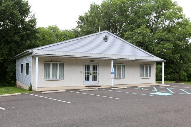
Property Record
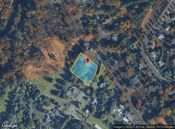
1600 Lower State Rd, Doylestown, PA 18901


NEARBY LISTINGS FOR SALE OR LEASE
Property Detail
1600 Lower State Rd
09-007-028-001
1.35A N S LR09041 2030 FT E LR09034
Storebuilding
Bucks
X
Pennsylvania
42017C0293J
1ns
2024
1.35 AC
2025
Lower Bucks County
104603
Philadelphia
1,880 SF
Philadelphia-Camden-Wilmington, PA-NJ-DE-MD
DEMOGRAPHICS near 1600 Lower State Rd
1 Mile
3 Mile
5 Mile
2024 Total Population
3,403
47,552
123,638
2029 Population
3,402
47,725
124,063
Pop Growth 2024-2029
(0.03%)
+ 0.36%
+ 0.34%
Average Age
41
43
43
2024 Total Households
1,048
16,888
45,536
HH Growth 2024-2029
0.00%
+ 0.36%
+ 0.41%
Median Household Inc
$168,396
$126,501
$123,763
Avg Household Size
3.10
2.60
2.60
2024 Avg HH Vehicles
2.00
2.00
2.00
Median Home Value
$639,706
$488,403
$461,451
Median Year Built
1988
1984
1985
Nearby Places
Map Layers
Map Styles
 Street
 Aerial
- Restaurants
- Banks
- Shops
- Fitness
- Groceries
PUBLIC TRANSPORTATION
COMMUTER RAIL
New Britain (R5 - Southeastern Pennsylvania Transportation Authority Regional Rail (SEPTA Regional Rail))
DRIVE
WALK
Distance
New Britain (R5 - Southeastern Pennsylvania Transportation Authority Regional Rail (SEPTA Regional Rail))
5 min
2.2 mi
Delaware Valley College (R5 - Southeastern Pennsylvania Transportation Authority Regional Rail (SEPTA Regional Rail))
DRIVE
WALK
Distance
Delaware Valley College (R5 - Southeastern Pennsylvania Transportation Authority Regional Rail (SEPTA Regional Rail))
7 min
2.3 mi
AIRPORT
Trenton Mercer
DRIVE
WALK
Distance
Trenton Mercer
42 min
25.1 mi
Philadelphia International
DRIVE
WALK
Distance
Philadelphia International
64 min
37.4 mi
Lehigh Valley International
DRIVE
WALK
Distance
Lehigh Valley International
65 min
39.3 mi
Freight Ports
Port of Philadelphia
DRIVE
WALK
Distance
Port of Philadelphia
42 min
25.9 mi
Nearby Properties
Address
Land Use
TOTAL SIZE
Lot Size
Zoning
Address
Land Use
TOTAL SIZE
Lot Size
Zoning
8,120 SF
56.80 AC
C3
Address
Land Use
TOTAL SIZE
Lot Size
Zoning
30,939 SF
28.69 AC
I
Address
Land Use
TOTAL SIZE
Lot Size
Zoning
254,330 SF
25.38 AC
C2
Address
Land Use
TOTAL SIZE
Lot Size
Zoning
89,344 SF
9.69 AC
R2
Address
Land Use
TOTAL SIZE
Lot Size
Zoning
344,604 SF
6.95 AC
LI
Address
Land Use
TOTAL SIZE
Lot Size
Zoning
23,500 SF
7.65 AC
R1
Address
Land Use
TOTAL SIZE
Lot Size
Zoning
146,924 SF
17.47 AC
C2
Address
Land Use
TOTAL SIZE
Lot Size
Zoning
77,630 SF
28.53 AC
R2B
Address
Land Use
TOTAL SIZE
Lot Size
Zoning
10,252 SF
36.82 AC
R2
Address
Land Use
TOTAL SIZE
Lot Size
Zoning
15,475 SF
8.89 AC
R1
Address
Land Use
TOTAL SIZE
Lot Size
Zoning
77,964 SF
9.79 AC
R3
Address
Land Use
TOTAL SIZE
Lot Size
Zoning
54,090 SF
7.25 AC
R4
Address
Land Use
TOTAL SIZE
Lot Size
Zoning
25,188 SF
8.51 AC
R2
Address
Land Use
TOTAL SIZE
Lot Size
Zoning
153,564 SF
13.12 AC
R2
Address
Land Use
TOTAL SIZE
Lot Size
Zoning
11,159 SF
304.23 AC
Q
Address
Land Use
TOTAL SIZE
Lot Size
Zoning
63,612 SF
0.47 AC
CI
Address
Land Use
TOTAL SIZE
Lot Size
Zoning
33,658 SF
0.52 AC
Address
Land Use
TOTAL SIZE
Lot Size
Zoning
68,700 SF
8.41 AC
C3
Address
Land Use
TOTAL SIZE
Lot Size
Zoning
63,612 SF
0.50 AC
CI
Address
Land Use
TOTAL SIZE
Lot Size
Zoning
24,195 SF
1.50 AC
R2
Address
Land Use
TOTAL SIZE
Lot Size
Zoning
61,558 SF
7.48 AC
C2
Address
Land Use
TOTAL SIZE
Lot Size
Zoning
26,134 SF
8.37 AC
C2
Address
Land Use
TOTAL SIZE
Lot Size
Zoning
31,122 SF
9.86 AC
C2
Address
Land Use
TOTAL SIZE
Lot Size
Zoning
42,587 SF
12.09 AC
R1
Address
Land Use
TOTAL SIZE
Lot Size
Zoning
24,300 SF
3.36 AC
C1
Address
Land Use
TOTAL SIZE
Lot Size
Zoning
21,285 SF
118.88 AC
R1
Address
Land Use
TOTAL SIZE
Lot Size
Zoning
63,612 SF
0.52 AC
CI
Address
Land Use
TOTAL SIZE
Lot Size
Zoning
52,976 SF
5.80 AC
C-2
Address
Land Use
TOTAL SIZE
Lot Size
Zoning
36,635 SF
2.97 AC
CR-H
Address
Land Use
TOTAL SIZE
Lot Size
Zoning
13,875 SF
3.09 AC
R1
The World's #1 Commercial Real Estate Marketplace
Connect with us
© 2025 CoStar Group
The information above has been obtained from sources believed reliable. While we do not doubt its accuracy we have not verified it and make no guarantee, warranty or representation about it. It is your responsibility to independently confirm its accuracy and completeness. Any projections, opinions, assumptions, or estimates used are for example only and do not represent the current or future performance of the property. The value of this transaction to you depends on tax and other factors which should be evaluated by your tax, financial, and legal advisors. You and your advisors should conduct a careful, independent investigation of the property to determine to your satisfaction the suitability of the property for your needs.