Property Record
1600 Mcpherson Ave, Council Bluffs, IA 51503

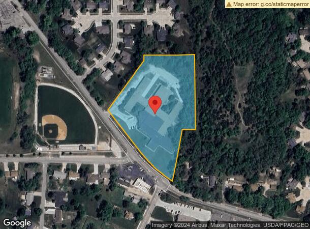

This Property Is For Sale
NEARBY LISTINGS FOR SALE OR LEASE
-
-
View all Council Bluffs listings for sale on LoopNet.com
Property Detail
1600 Mcpherson Ave
Omaha-Council Bluffs, NE-IA
Aud Sub
7543-29-376-004
SECTION 29-75-43 PT LT 2 AUD SUB SE SW PT LT 1 AUD SUB NE NW 32-75-43 COMM 520'E 16'N OF SW COR SE~SW TH NW ALONG NELY ROW350' NE355.92' N29'E292.67' S433.31' W75' SW300' TO NELY ROW NWLY203.92' TO~POB
Publicstorage
Pottawattamie
X
Iowa
31055C0275H
2-1
2025
5.52 AC
2025
Council Bluffs
031700
Omaha/Council Bluffs
56,878 SF
DEMOGRAPHICS near 1600 Mcpherson Ave
1 Mile
3 Mile
5 Mile
2024 Total Population
6,064
40,079
67,679
2029 Population
6,011
39,870
67,291
Pop Growth 2024-2029
(0.87%)
(0.52%)
(0.57%)
Average Age
42
41
41
2024 Total Households
2,346
16,018
26,609
HH Growth 2024-2029
(1.07%)
(0.56%)
(0.62%)
Median Household Inc
$85,553
$68,448
$63,446
Avg Household Size
2.30
2.30
2.40
2024 Avg HH Vehicles
2.00
2.00
2.00
Median Home Value
$198,037
$190,287
$171,992
Median Year Built
1973
1965
1965
Nearby Places
Map Layers
Map Styles
 Street
 Aerial
- Restaurants
- Banks
- Shops
- Fitness
- Groceries
PUBLIC TRANSPORTATION
COMMUTER RAIL
DRIVE
WALK
Distance
14 min
9.3 mi
DRIVE
WALK
Distance
15 min
9.4 mi
AIRPORT
Eppley Airfield
DRIVE
WALK
Distance
Eppley Airfield
23 min
12.6 mi
Nearby Properties
Address
Land Use
TOTAL SIZE
Lot Size
Zoning
Address
Land Use
TOTAL SIZE
Lot Size
Zoning
185.50 AC
A-2
Address
Land Use
TOTAL SIZE
Lot Size
Zoning
11.85 AC
R-3
Address
Land Use
TOTAL SIZE
Lot Size
Zoning
16.87 AC
P-C
Address
Land Use
TOTAL SIZE
Lot Size
Zoning
17.49 AC
R-3
Address
Land Use
TOTAL SIZE
Lot Size
Zoning
2.91 AC
A-P
Address
Land Use
TOTAL SIZE
Lot Size
Zoning
17.40 AC
A-P
Address
Land Use
TOTAL SIZE
Lot Size
Zoning
37.25 AC
I-2
Address
Land Use
TOTAL SIZE
Lot Size
Zoning
4,216 SF
17.29 AC
R-4
Address
Land Use
TOTAL SIZE
Lot Size
Zoning
22.91 AC
A-P
Address
Land Use
TOTAL SIZE
Lot Size
Zoning
30.64 AC
R-1
Address
Land Use
TOTAL SIZE
Lot Size
Zoning
8.34 AC
R-3
Address
Land Use
TOTAL SIZE
Lot Size
Zoning
1.99 AC
C-3
Address
Land Use
TOTAL SIZE
Lot Size
Zoning
21.72 AC
I-2
Address
Land Use
TOTAL SIZE
Lot Size
Zoning
21.91 AC
P-C
Address
Land Use
TOTAL SIZE
Lot Size
Zoning
582.98 AC
A-2
Address
Land Use
TOTAL SIZE
Lot Size
Zoning
18.68 AC
C-2
Address
Land Use
TOTAL SIZE
Lot Size
Zoning
18.41 AC
R-3
Address
Land Use
TOTAL SIZE
Lot Size
Zoning
9.06 AC
R-3
Address
Land Use
TOTAL SIZE
Lot Size
Zoning
4.48 AC
R-4
Address
Land Use
TOTAL SIZE
Lot Size
Zoning
7.72 AC
P-C
Address
Land Use
TOTAL SIZE
Lot Size
Zoning
7.17 AC
R-3
Address
Land Use
TOTAL SIZE
Lot Size
Zoning
8.42 AC
R-3
Address
Land Use
TOTAL SIZE
Lot Size
Zoning
28.70 AC
A-P
Address
Land Use
TOTAL SIZE
Lot Size
Zoning
4.87 AC
C-2
Address
Land Use
TOTAL SIZE
Lot Size
Zoning
864 SF
7.37 AC
C-2
Address
Land Use
TOTAL SIZE
Lot Size
Zoning
81.55 AC
A-2
Address
Land Use
TOTAL SIZE
Lot Size
Zoning
13.81 AC
P-C
Address
Land Use
TOTAL SIZE
Lot Size
Zoning
201,260 SF
10.65 AC
C-4
Address
Land Use
TOTAL SIZE
Lot Size
Zoning
10.96 AC
R-1
Address
Land Use
TOTAL SIZE
Lot Size
Zoning
5.66 AC
R-3
The World's #1 Commercial Real Estate Marketplace
Connect with us
© 2026 CoStar Group
The information above has been obtained from sources believed reliable. While we do not doubt its accuracy we have not verified it and make no guarantee, warranty or representation about it. It is your responsibility to independently confirm its accuracy and completeness. Any projections, opinions, assumptions, or estimates used are for example only and do not represent the current or future performance of the property. The value of this transaction to you depends on tax and other factors which should be evaluated by your tax, financial, and legal advisors. You and your advisors should conduct a careful, independent investigation of the property to determine to your satisfaction the suitability of the property for your needs.