Property Record
1600 N Us Highway 27 Hwy, Portland, IN 47371
NEARBY LISTINGS FOR SALE OR LEASE
Property Detail
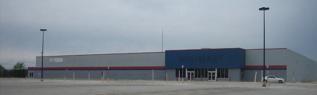
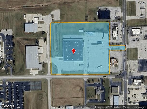
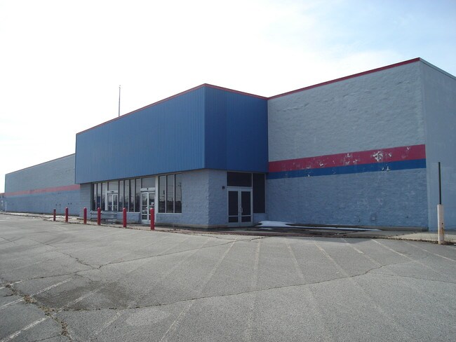
1600 N Us Highway 27 Hwy
Warehouse
PT E 1/2 NE 1/4 S17 T23 R14 10.772 A
X
Jay
18075C0153B
Indiana
2024
10.77 AC
2024
Indiana North Area
963000
Other Market Areas
66,808 SF
38-07-17-100-017.000-034
DEMOGRAPHICS near 1600 N Us Highway 27 Hwy
1 Mile
3 Mile
5 Mile
2024 Total Population
1,948
7,888
9,504
2029 Population
1,939
7,861
9,437
Pop Growth 2024-2029
(0.46%)
(0.34%)
(0.70%)
Average Age
39
41
40
2024 Total Households
805
3,277
3,849
HH Growth 2024-2029
(0.62%)
(0.40%)
(0.70%)
Median Household Inc
$42,962
$46,554
$49,357
Avg Household Size
2.30
2.30
2.40
2024 Avg HH Vehicles
2.00
2.00
2.00
Median Home Value
$89,080
$92,514
$107,052
Median Year Built
1947
1954
1955
Nearby Places
Map Layers
Map Styles
 Street
 Aerial
- Restaurants
- Banks
- Shops
- Fitness
- Groceries
SALE & LEASE HISTORY
LISTING DATE
SALE/LEASE

Sep 25, 2016
For Lease
Sep 24, 2016
For Sale
Feb 06, 2019
For Lease
Feb 06, 2019
For Sale
Nearby Properties
Address
Land Use
TOTAL SIZE
Lot Size
Zoning
Address
Land Use
TOTAL SIZE
Lot Size
Zoning
371,447 SF
29.62 AC
Address
Land Use
TOTAL SIZE
Lot Size
Zoning
154,076 SF
17.80 AC
Address
Land Use
TOTAL SIZE
Lot Size
Zoning
123,065 SF
31.66 AC
Address
Land Use
TOTAL SIZE
Lot Size
Zoning
44,880 SF
4.72 AC
Address
Land Use
TOTAL SIZE
Lot Size
Zoning
49,600 SF
6.15 AC
Address
Land Use
TOTAL SIZE
Lot Size
Zoning
76,725 SF
8.39 AC
Address
Land Use
TOTAL SIZE
Lot Size
Zoning
40,182 SF
0.45 AC
Address
Land Use
TOTAL SIZE
Lot Size
Zoning
196,000 SF
35.96 AC
Address
Land Use
TOTAL SIZE
Lot Size
Zoning
44,316 SF
0.40 AC
Address
Land Use
TOTAL SIZE
Lot Size
Zoning
22,688 SF
3.13 AC
Address
Land Use
TOTAL SIZE
Lot Size
Zoning
22,500 SF
11.02 AC
Address
Land Use
TOTAL SIZE
Lot Size
Zoning
127,739 SF
23.05 AC
Address
Land Use
TOTAL SIZE
Lot Size
Zoning
20,726 SF
0.42 AC
Address
Land Use
TOTAL SIZE
Lot Size
Zoning
77,700 SF
15.04 AC
Address
Land Use
TOTAL SIZE
Lot Size
Zoning
72,132 SF
8.54 AC
Address
Land Use
TOTAL SIZE
Lot Size
Zoning
81,600 SF
12.73 AC
Address
Land Use
TOTAL SIZE
Lot Size
Zoning
40,518 SF
0.94 AC
Address
Land Use
TOTAL SIZE
Lot Size
Zoning
125,476 SF
23.36 AC
Address
Land Use
TOTAL SIZE
Lot Size
Zoning
72,822 SF
15.06 AC
Address
Land Use
TOTAL SIZE
Lot Size
Zoning
134,636 SF
10.52 AC
Address
Land Use
TOTAL SIZE
Lot Size
Zoning
13,566 SF
0.44 AC
Address
Land Use
TOTAL SIZE
Lot Size
Zoning
131,208 SF
11.79 AC
Address
Land Use
TOTAL SIZE
Lot Size
Zoning
81,918 SF
35.24 AC
Address
Land Use
TOTAL SIZE
Lot Size
Zoning
2,132 SF
1.49 AC
Address
Land Use
TOTAL SIZE
Lot Size
Zoning
27,622 SF
0.40 AC
Address
Land Use
TOTAL SIZE
Lot Size
Zoning
10,000 SF
14.95 AC
Address
Land Use
TOTAL SIZE
Lot Size
Zoning
79,528 SF
20 AC
Address
Land Use
TOTAL SIZE
Lot Size
Zoning
73,243 SF
3.15 AC
Address
Land Use
TOTAL SIZE
Lot Size
Zoning
8,641 SF
14.13 AC
The World's #1 Commercial Real Estate Marketplace
Connect with us
© 2025 CoStar Group
The information above has been obtained from sources believed reliable. While we do not doubt its accuracy we have not verified it and make no guarantee, warranty or representation about it. It is your responsibility to independently confirm its accuracy and completeness. Any projections, opinions, assumptions, or estimates used are for example only and do not represent the current or future performance of the property. The value of this transaction to you depends on tax and other factors which should be evaluated by your tax, financial, and legal advisors. You and your advisors should conduct a careful, independent investigation of the property to determine to your satisfaction the suitability of the property for your needs.