Property Record
Planeview Dr, Oshkosh, WI 54904
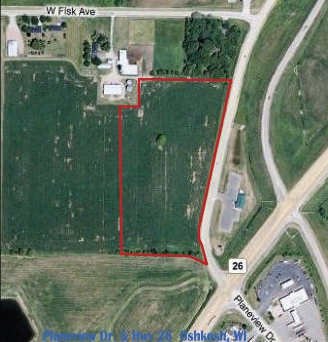
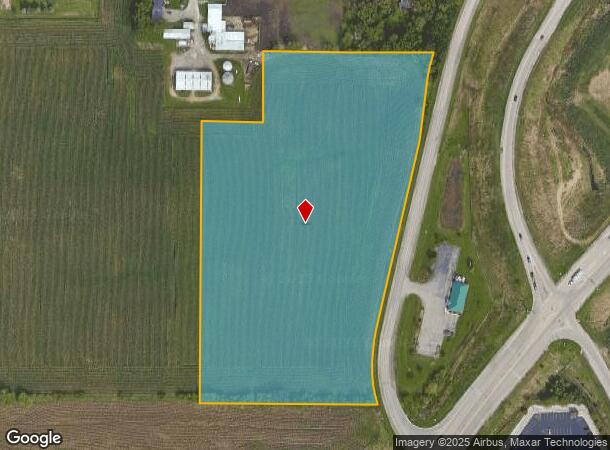
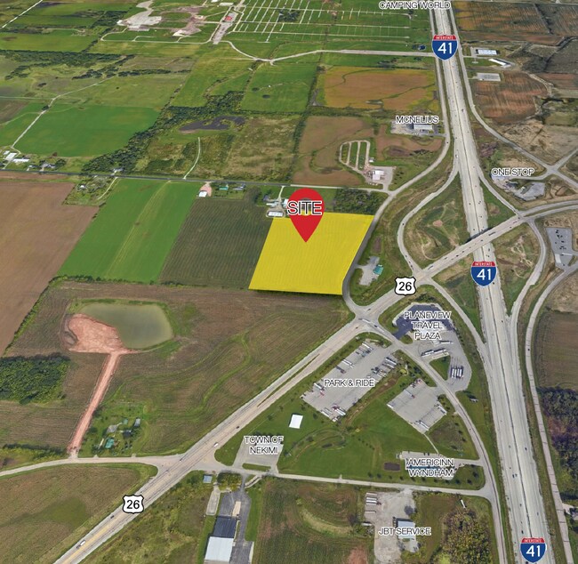
This Property Is For Sale
NEARBY LISTINGS FOR SALE OR LEASE
Property Detail
Planeview Dr
13-69050000
A PRT OF NW1/4 NE1/4 & NE1/4 NE1/4 SEC 16-17-16 DESC AS;BEG AT A PT 1469.64 FT N89D0812E, & 330 FT S00D5922E OFNW COR NE1/4 SD SEC 16-17-16; TH N89D081 TO WLY R/W LI
Agriculturalland
Winnebago
X
Wisconsin
55039C0100F
7 AC
2024
Appleton/Oshkosh
2024
Other Market Areas
001803
Oshkosh-Neenah, WI
DEMOGRAPHICS near Planeview Dr
1 Mile
3 Mile
5 Mile
2024 Total Population
80
2,753
29,174
2029 Population
83
2,837
29,618
Pop Growth 2024-2029
+ 3.75%
+ 3.05%
+ 1.52%
Average Age
46
46
42
2024 Total Households
38
1,288
13,093
HH Growth 2024-2029
+ 5.26%
+ 3.03%
+ 1.52%
Median Household Inc
$89,285
$87,608
$69,935
Avg Household Size
2.10
2.10
2.20
2024 Avg HH Vehicles
2.00
2.00
2.00
Median Home Value
$259,090
$262,391
$200,917
Median Year Built
1997
1994
1976
Nearby Places
Map Layers
Map Styles
 Street
 Aerial
- Restaurants
- Banks
- Shops
- Fitness
- Groceries
PUBLIC TRANSPORTATION
AIRPORT
Appleton International
DRIVE
WALK
Distance
Appleton International
33 min
26.2 mi
Freight Ports
Port Milwaukee
DRIVE
WALK
Distance
Port Milwaukee
98 min
83.1 mi
Nearby Properties
Address
Land Use
TOTAL SIZE
Lot Size
Zoning
Address
Land Use
TOTAL SIZE
Lot Size
Zoning
931,304 SF
107 AC
M3
Address
Land Use
TOTAL SIZE
Lot Size
Zoning
15.37 AC
SMU-PD
Address
Land Use
TOTAL SIZE
Lot Size
Zoning
18.38 AC
UIPD
Address
Land Use
TOTAL SIZE
Lot Size
Zoning
41.70 AC
HI
Address
Land Use
TOTAL SIZE
Lot Size
Zoning
110,200 SF
14.77 AC
MR-12-PD
Address
Land Use
TOTAL SIZE
Lot Size
Zoning
238,238 SF
22.60 AC
M3
Address
Land Use
TOTAL SIZE
Lot Size
Zoning
271,088 SF
36.80 AC
M3
Address
Land Use
TOTAL SIZE
Lot Size
Zoning
58,465 SF
43.67 AC
M3
Address
Land Use
TOTAL SIZE
Lot Size
Zoning
32,430 SF
7.44 AC
M1
Address
Land Use
TOTAL SIZE
Lot Size
Zoning
28,512 SF
6.20 AC
M1
Address
Land Use
TOTAL SIZE
Lot Size
Zoning
42,092 SF
3.21 AC
C2
Address
Land Use
TOTAL SIZE
Lot Size
Zoning
126,814 SF
22.60 AC
HI
Address
Land Use
TOTAL SIZE
Lot Size
Zoning
210,000 SF
10.02 AC
M3
Address
Land Use
TOTAL SIZE
Lot Size
Zoning
62,880 SF
5.78 AC
M3
Address
Land Use
TOTAL SIZE
Lot Size
Zoning
66,456 SF
5.91 AC
MR-12-PD
Address
Land Use
TOTAL SIZE
Lot Size
Zoning
38,858 SF
8.15 AC
M1
Address
Land Use
TOTAL SIZE
Lot Size
Zoning
13.67 AC
Address
Land Use
TOTAL SIZE
Lot Size
Zoning
13.75 AC
Address
Land Use
TOTAL SIZE
Lot Size
Zoning
16.34 AC
Address
Land Use
TOTAL SIZE
Lot Size
Zoning
20,544 SF
4.16 AC
M-1PD
Address
Land Use
TOTAL SIZE
Lot Size
Zoning
67,734 SF
5.62 AC
MR-12-PD
Address
Land Use
TOTAL SIZE
Lot Size
Zoning
150,000 SF
17.87 AC
M3
Address
Land Use
TOTAL SIZE
Lot Size
Zoning
162,500 SF
11.58 AC
M3
Address
Land Use
TOTAL SIZE
Lot Size
Zoning
596 SF
4.94 AC
R3
Address
Land Use
TOTAL SIZE
Lot Size
Zoning
89,520 SF
7 AC
M3
Address
Land Use
TOTAL SIZE
Lot Size
Zoning
561 SF
8.24 AC
R3
Address
Land Use
TOTAL SIZE
Lot Size
Zoning
26.03 AC
Address
Land Use
TOTAL SIZE
Lot Size
Zoning
96,967 SF
3.42 AC
M2
Address
Land Use
TOTAL SIZE
Lot Size
Zoning
57,297 SF
3.23 AC
M1
Address
Land Use
TOTAL SIZE
Lot Size
Zoning
26.05 AC
The World's #1 Commercial Real Estate Marketplace
Connect with us
© 2025 CoStar Group
The information above has been obtained from sources believed reliable. While we do not doubt its accuracy we have not verified it and make no guarantee, warranty or representation about it. It is your responsibility to independently confirm its accuracy and completeness. Any projections, opinions, assumptions, or estimates used are for example only and do not represent the current or future performance of the property. The value of this transaction to you depends on tax and other factors which should be evaluated by your tax, financial, and legal advisors. You and your advisors should conduct a careful, independent investigation of the property to determine to your satisfaction the suitability of the property for your needs.