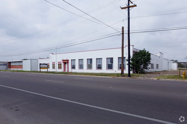
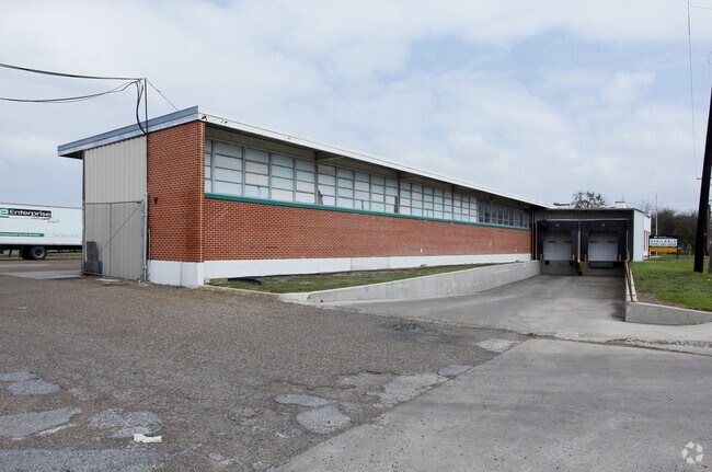
Property Record
1600 W Harrison Ave, Harlingen, TX 78550

NEARBY LISTINGS FOR SALE OR LEASE
Property Detail
1600 W Harrison Ave
224100-0320-004000
Petersburg Syndicate Subdivision
Commercialnec
HARLINGEN - PETERSBURG BLK 32 SOFR, 2.0300 ACRES
X
Cameron
48061C0255F
Texas
2024
2.03 AC
2025
Greater Harlingen
010500
Brownsville/Harlingen
36,354 SF
Brownsville-Harlingen, TX
DEMOGRAPHICS near 1600 W Harrison Ave
1 Mile
3 Mile
5 Mile
2024 Total Population
7,011
65,362
97,015
2029 Population
7,202
66,889
99,165
Pop Growth 2024-2029
+ 2.72%
+ 2.34%
+ 2.22%
Average Age
36
37
37
2024 Total Households
2,275
22,618
33,250
HH Growth 2024-2029
+ 2.68%
+ 2.34%
+ 2.18%
Median Household Inc
$32,446
$48,356
$52,026
Avg Household Size
2.90
2.80
2.80
2024 Avg HH Vehicles
1.00
2.00
2.00
Median Home Value
$60,983
$95,620
$108,674
Median Year Built
1971
1984
1987
Nearby Places
Map Layers
Map Styles
 Street
 Aerial
- Restaurants
- Banks
- Shops
- Fitness
- Groceries
PUBLIC TRANSPORTATION
AIRPORT
Valley International
DRIVE
WALK
Distance
Valley International
10 min
5.3 mi
Brownsville/South Padre Island International
DRIVE
WALK
Distance
Brownsville/South Padre Island International
37 min
28.6 mi
Freight Ports
Port of Brownsville
DRIVE
WALK
Distance
Port of Brownsville
30 min
26.3 mi
Nearby Properties
Address
Land Use
TOTAL SIZE
Lot Size
Zoning
Address
Land Use
TOTAL SIZE
Lot Size
Zoning
758,640 SF
11.31 AC
Address
Land Use
TOTAL SIZE
Lot Size
Zoning
246,234 SF
16.40 AC
Address
Land Use
TOTAL SIZE
Lot Size
Zoning
43,540 SF
26.19 AC
C
Address
Land Use
TOTAL SIZE
Lot Size
Zoning
293,886 SF
23.57 AC
Address
Land Use
TOTAL SIZE
Lot Size
Zoning
171,714 SF
16.03 AC
C
Address
Land Use
TOTAL SIZE
Lot Size
Zoning
74,848 SF
2.30 AC
Address
Land Use
TOTAL SIZE
Lot Size
Zoning
391,617 SF
23.20 AC
C
Address
Land Use
TOTAL SIZE
Lot Size
Zoning
41,182 SF
34.14 AC
M-R
Address
Land Use
TOTAL SIZE
Lot Size
Zoning
176,365 SF
14.65 AC
Address
Land Use
TOTAL SIZE
Lot Size
Zoning
135,258 SF
4.26 AC
C
Address
Land Use
TOTAL SIZE
Lot Size
Zoning
148,596 SF
1 AC
Address
Land Use
TOTAL SIZE
Lot Size
Zoning
72,063 SF
2.29 AC
Address
Land Use
TOTAL SIZE
Lot Size
Zoning
152,724 SF
17.78 AC
Address
Land Use
TOTAL SIZE
Lot Size
Zoning
63,450 SF
2.88 AC
Address
Land Use
TOTAL SIZE
Lot Size
Zoning
13,924 SF
31.33 AC
C
Address
Land Use
TOTAL SIZE
Lot Size
Zoning
77,189 SF
3.28 AC
Address
Land Use
TOTAL SIZE
Lot Size
Zoning
177,812 SF
21.40 AC
C
Address
Land Use
TOTAL SIZE
Lot Size
Zoning
41,370 SF
3.40 AC
C
Address
Land Use
TOTAL SIZE
Lot Size
Zoning
76,756 SF
15.35 AC
Address
Land Use
TOTAL SIZE
Lot Size
Zoning
63,381 SF
3.15 AC
Address
Land Use
TOTAL SIZE
Lot Size
Zoning
81,569 SF
36.61 AC
Address
Land Use
TOTAL SIZE
Lot Size
Zoning
91,630 SF
11.17 AC
Address
Land Use
TOTAL SIZE
Lot Size
Zoning
89,508 SF
9.90 AC
Address
Land Use
TOTAL SIZE
Lot Size
Zoning
20,062 SF
47.54 AC
C
Address
Land Use
TOTAL SIZE
Lot Size
Zoning
47,539 SF
8.77 AC
C
Address
Land Use
TOTAL SIZE
Lot Size
Zoning
134,367 SF
14.42 AC
Address
Land Use
TOTAL SIZE
Lot Size
Zoning
138,862 SF
15.82 AC
Address
Land Use
TOTAL SIZE
Lot Size
Zoning
206,973 SF
12.77 AC
Address
Land Use
TOTAL SIZE
Lot Size
Zoning
79,466 SF
6.23 AC
C
Address
Land Use
TOTAL SIZE
Lot Size
Zoning
68,826 SF
6.27 AC
The World's #1 Commercial Real Estate Marketplace
Connect with us
© 2026 CoStar Group
The information above has been obtained from sources believed reliable. While we do not doubt its accuracy we have not verified it and make no guarantee, warranty or representation about it. It is your responsibility to independently confirm its accuracy and completeness. Any projections, opinions, assumptions, or estimates used are for example only and do not represent the current or future performance of the property. The value of this transaction to you depends on tax and other factors which should be evaluated by your tax, financial, and legal advisors. You and your advisors should conduct a careful, independent investigation of the property to determine to your satisfaction the suitability of the property for your needs.