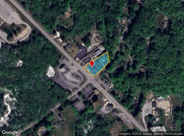
Property Record
1601 Hartford New London Tpke, Oakdale, CT 06370

NEARBY LISTINGS FOR SALE OR LEASE
Property Detail
1601 Hartford New London Tpke
MONT-000005-000016
New London
Commercialnec
Connecticut
X
0.61 AC
09011C0337G
SW New London/East Lyme
2025
Hartford
2025
Norwich-New London, CT
695202
DEMOGRAPHICS near 1601 Hartford New London Tpke
1 Mile
3 Mile
5 Mile
2024 Total Population
585
4,556
18,573
2029 Population
580
4,530
18,448
Pop Growth 2024-2029
(0.85%)
(0.57%)
(0.67%)
Average Age
43
42
43
2024 Total Households
230
1,689
7,197
HH Growth 2024-2029
(0.87%)
(0.59%)
(0.79%)
Median Household Inc
$107,870
$113,326
$103,970
Avg Household Size
2.50
2.60
2.50
2024 Avg HH Vehicles
3.00
2.00
2.00
Median Home Value
$253,846
$300,737
$309,279
Median Year Built
1972
1981
1980
Nearby Places
Map Layers
Map Styles
 Street
 Aerial
- Restaurants
- Banks
- Shops
- Fitness
- Groceries
PUBLIC TRANSPORTATION
COMMUTER RAIL
New London (Shore Line East - Shore Line East)
DRIVE
WALK
Distance
New London (Shore Line East - Shore Line East)
15 min
8.7 mi
Freight Ports
Port of New Haven
DRIVE
WALK
Distance
Port of New Haven
58 min
44.2 mi
SALE & LEASE HISTORY
LISTING DATE
SALE/LEASE

Dec 21, 2020
For Sale
Nearby Properties
Address
Land Use
TOTAL SIZE
Lot Size
Zoning
Address
Land Use
TOTAL SIZE
Lot Size
Zoning
62,316 SF
18.12 AC
GOV
Address
Land Use
TOTAL SIZE
Lot Size
Zoning
5.01 AC
C-1
Address
Land Use
TOTAL SIZE
Lot Size
Zoning
105,050 SF
9.39 AC
LI
Address
Land Use
TOTAL SIZE
Lot Size
Zoning
301.43 AC
SU-E
Address
Land Use
TOTAL SIZE
Lot Size
Zoning
11.50 AC
R40
Address
Land Use
TOTAL SIZE
Lot Size
Zoning
76,725 SF
10.65 AC
LI
Address
Land Use
TOTAL SIZE
Lot Size
Zoning
19.34 AC
RU120
Address
Land Use
TOTAL SIZE
Lot Size
Zoning
57.02 AC
C-2
Address
Land Use
TOTAL SIZE
Lot Size
Zoning
52.72 AC
R40
Address
Land Use
TOTAL SIZE
Lot Size
Zoning
385 AC
Address
Land Use
TOTAL SIZE
Lot Size
Zoning
1,886 SF
93.90 AC
R40
Address
Land Use
TOTAL SIZE
Lot Size
Zoning
25,344 SF
5.12 AC
C-2
Address
Land Use
TOTAL SIZE
Lot Size
Zoning
14,136 SF
0.93 AC
GOV
Address
Land Use
TOTAL SIZE
Lot Size
Zoning
4,862 SF
2.48 AC
C-1
Address
Land Use
TOTAL SIZE
Lot Size
Zoning
861 AC
RU-B
Address
Land Use
TOTAL SIZE
Lot Size
Zoning
2.82 AC
LI
Address
Land Use
TOTAL SIZE
Lot Size
Zoning
540 SF
22.55 AC
WRP
Address
Land Use
TOTAL SIZE
Lot Size
Zoning
19,092 SF
RU120
Address
Land Use
TOTAL SIZE
Lot Size
Zoning
2,054 SF
226 AC
WRP
Address
Land Use
TOTAL SIZE
Lot Size
Zoning
172 AC
Address
Land Use
TOTAL SIZE
Lot Size
Zoning
168 AC
RU120
Address
Land Use
TOTAL SIZE
Lot Size
Zoning
10,125 SF
5.06 AC
LI
Address
Land Use
TOTAL SIZE
Lot Size
Zoning
7,552 SF
1.54 AC
GOV
Address
Land Use
TOTAL SIZE
Lot Size
Zoning
264.97 AC
RU80
Address
Land Use
TOTAL SIZE
Lot Size
Zoning
588.20 AC
RU120
Address
Land Use
TOTAL SIZE
Lot Size
Zoning
10,000 SF
9.42 AC
LI
Address
Land Use
TOTAL SIZE
Lot Size
Zoning
8,160 SF
5.07 AC
IP-3
Address
Land Use
TOTAL SIZE
Lot Size
Zoning
4,875 SF
12.30 AC
LI
Address
Land Use
TOTAL SIZE
Lot Size
Zoning
250.94 AC
OS
Address
Land Use
TOTAL SIZE
Lot Size
Zoning
12,000 SF
6.27 AC
LI
The World's #1 Commercial Real Estate Marketplace
Connect with us
© 2025 CoStar Group
The information above has been obtained from sources believed reliable. While we do not doubt its accuracy we have not verified it and make no guarantee, warranty or representation about it. It is your responsibility to independently confirm its accuracy and completeness. Any projections, opinions, assumptions, or estimates used are for example only and do not represent the current or future performance of the property. The value of this transaction to you depends on tax and other factors which should be evaluated by your tax, financial, and legal advisors. You and your advisors should conduct a careful, independent investigation of the property to determine to your satisfaction the suitability of the property for your needs.